Upgrade in tomorrow's swell, tricky next week
Victorian Surf Forecast by Craig Brokensha (issued Friday July 26th)
Best Days: Today, tomorrow Surf Coast, early Sunday Surf Coast, Thursday and Friday next week
Features of the Forecast (tl;dr)
- Moderate + sized spike of W'ly swell tomorrow with gusty NW tending W/SW-W/NW winds
- Easing swell Sun with early W/NW tending strong SW winds
- Smaller Mon with W/NW tending gusty SW winds into the PM
- Tricky winds Tue, likely light N/NE in the AM
- Small W'ly swell for Wed AM, easing with winds unknown
- Moderate + sized W/SW groundswell Thursday with winds unknown
Recap
The surf was small and clean yesterday morning with 2ft sets hanging in on the Surf Coast magnets, 3ft or so to the east but with unfavourable winds that improved a little into the afternoon.
A new pulse of mid-period W/SW swell started to show into yesterday afternoon with it peaking this morning to a fun 3ft on the Surf Coast with generally favourable winds and conditions. Locations to the east are bigger but a little wind affected again.
We can expect this morning’s swell to ease through the day as winds strengthen from the N/NW.

Great conditions for the dawny this morning
This weekend and next week (Jul 27 - Aug 2)
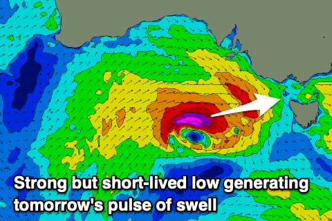
The weekend ahead all revolves around the size of the swell coming from a tricky but strong mid-latitude frontal system that’s currently approaching from the west.

The majority of the fetch around the storm is weak and misaligned, but a tight low pressure centre is generating W’ly gales that may even reach severe-gale during today in our western swell window.
This will result in a quick spike of swell tomorrow, likely now reaching 4ft on the Surf Coast magnets during the morning with 6ft+ sets to the east, backing off later and then smaller Sunday from 3ft and 4-5ft respectively west and east of Melbourne.
Conditions look good for the Surf Coast tomorrow with a fresh to strong NW tending W/SW briefly early afternoon reverting back to the W/NW into the mid-late afternoon.
Sunday will be a little trickier with early W/NW winds due to swing SW and strengthen during the morning, creating poor conditions once it moves through.
Monday looks smaller and W/NW winds will again favour the Surf Coast before a trough moves through, bringing strengthening SW winds into the afternoon.
Now as touched on in Wednesday’s notes, from Tuesday we should see conditions improve for the exposed beaches as a high moves in from the west, but a significant low forming in the Tasman Sea may spoil things mid-late week as it pushes the high back west.
GFS has it retrograding next week bringing less favourable S’ly winds mid-late week but we’ll have to watch this one closely.
Swell wise, Tuesday looks tiny on the Surf Coast with 2ft waves to the ease under a N/NE offshore, while later in the day but more so Wednesday morning, an inconsistent W’ly swell is due.
The source is tricky and unfavourable with an east-southeast tracking frontal system from the Indian Ocean due to generate W/NW winds through our western swell window.
The Surf Coast will be lucky to top an inconsistent 1-2ft with better 3ft+ sets to the east, easing through the day and with winds a little unsure depending on the lows movement.

On Thursday, a stronger W/SW groundswell is due, generated by a significant storm firing up from the Southern Ocean, towards Western Australia/Indonesia.
We’re set to see a great fetch of severe-gale to storm-force W/SW winds generated through our medium to long-range swell window, with moderate + sized levels of W/SW swell due to arrive overnight Wednesday, peaking Thursday.
The Surf Coast should see surf to 3-5ft with 6ft to occasionally 8ft sets to the east with winds still tricky to nail down. We’ll have a closer look at this Monday. Have a great weekend!

