Less consistent west swells inbound, options opening up to the east next week
Victorian Surf Forecast by Craig Brokensha (issued Wednesday July 24th)
Best Days: Today, Friday, Saturday Surf Coast, early Sunday Surf Coast, Tuesday through Friday next week more exposed coasts
Features of the Forecast (tl;dr)
- Inconsistent, small-moderate sized W/SW swell building tomorrow PM, peaking Fri AM, then easing
- Strong but easing N/NW winds tomorrow
- Strong N/NW winds Fri, possibly tending N at times
- Moderate sized W swell for Sat, easing Sun
- Fresh to strong W/NW-W winds Sat, W/NW tending fresh SW Sun
- Smaller Mon with W/NW tending SW winds
- Smaller swells next week with winds from the northern quadrant
Recap
Some stronger, reinforcing SW groundswell that was seen into Monday afternoon and evening, held most of yesterday as winds varied from the N’th to NW, creating improving conditions as the day went on across the Surf Coast. The swell was in the 4-6ft range with 6ft+ sets to the east, best in slightly protected spots.
This morning the swell is on the ease and N’ly winds are favouring the beaches with easing 3-4ft waves on the Surf Coast, 4-6ft to the east. Winds will strengthen during the day and hold from the N-N/NE, favouring some spots over others as the swell continues to ease.

Pumping surf yesterday afternoon
This week and weekend (Jul 25 - 28)
The current swell will continue to ease into tomorrow morning, but through the late afternoon and more so Friday morning, our new mid-period W/SW swell is due to fill in.
As touched on in Monday’s notes, the source was a healthy but not overly strong frontal system that’s been projecting towards Western Australia and is now weakening south of the country.

It should come in at an inconsistent but fun 3ft on the Surf Coast magnets Friday morning with 4-5ft+ sets to the east, easing through the day.
Local winds will be strong from the N/NW tomorrow morning, easing into the late morning and remaining moderate to fresh into the afternoon. Friday will see strong N/NW winds most of the day, possibly tending N’ly at times but not enough to really favour the exposed beaches east of Melbourne. Instead adding lots of bump and small chops.
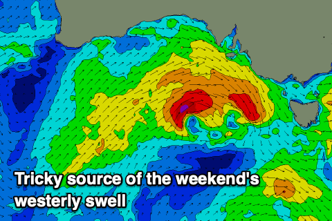
Looking at the weekend, and there was divergence regarding the strength and position of a cold front moving in on Friday, and we’ve now got some convergence with a tight and tricky system still on the cards.
We’re set to see a fetch of strong to gale-force W/NW winds moving through our western swell window on Friday, weakening once moving across us into the evening.

This should produce a tricky, moderate sized pulse of W’ly swell Saturday, reaching an inconsistent 3ft+ on the Surf Coast magnets with 5-6ft waves to the east.
Fresh to strong W/NW-W winds will favour protected spots all day with Sunday seeing a drop in the W’ly swell under a W/NW tending SW breeze. The Surf Coast looks to ease back from the 3ft range, smaller Monday with W/NW winds again through the morning.
Next week onwards (Jul 29 onwards)
Next week will be dominated by N’ly winds and smaller but fun swells that will favour the more exposed coasts.
A strong high will sit over the south-east of the country, directing a favourable offshore wind pattern across the state, but there’ll be no real major swell generating systems firing up in our close to medium range swell windows.
A strong cold outbreak to the south-west of Western Australia should bring some fun W/SW groundswell next Friday/Saturday but we’ll have a closer look at this on Friday.


Comments
Put the wetsuit on backwards in the dark Monday morning.Swell had some great moments.Offshore days and swell thanks Huey.
If it's zero foot and the surf report says it's 2ft, how many times wrong is the surf report?