Very slow week, strong swell for the weekend
Victorian Surf Forecast by Craig Brokensha (issued Monday July 8th)
Best Days: Today on the beaches, Saturday and early Sunday
Features of the Forecast (tl;dr)
- Swell bottoming out tomorrow and Wed
- Small pulse of W'ly swell very late Thu, peaking Fri AM and easing with fresh W/NW-NW winds
- Large W/SW groundswell building Saturday, peaking into the PM, easing Sun
- Fresh W/NW-NW winds Sat, early W/NW Sun then tending SW and strengthening mid-late AM
- Easing swell with gusty S winds, smaller Tue with SE winds
Recap
Finally some decent waves across both regions on the weekend. Our strong new pulse of SW groundswell came in nicely on Saturday with 4-5ft+ sets on the Surf Coast magnets, best on the beaches while locations to the east were a little overpowered.
Yesterday was better to the east with a drop in swell and great conditions, fun and easing from 3ft on the Surf Coast.
This morning we’ve fun levels of swell continuing thanks to a reinforcing pulse of S/SW energy with clean conditions across the beaches. Make the most of the surf before it bottoms out over the coming days.

Nice conditions yesterday morning
This week and weekend (Jul 9 - 14)
Now that the strong high that’s been dominating our swell window is now moving east, we’re seeing a flurry of strengthening frontal activity pushing up and towards Western Australia.

This will continue over the coming days, gaining ground on our state as it pushes the further east and out of the Tasman Sea.
With this we’re expected to see building levels of initially westerly swell energy, followed by what looks to be now a large W/SW groundswell for the weekend.
The first pulse of very average looking swell for late Thursday but more so Friday morning will be generated by a weak front passing under Western Australia tomorrow.
A broad fetch of strong W’ly winds will be generated through our western and south-western swell windows, with a small 2ft wave possible on the Surf Coast magnets Friday morning, 4ft to the east but with fresh W/NW-NW winds. This will only favour protected spots which will be small and slow.

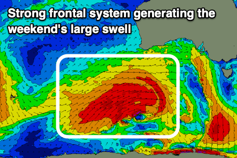
On the weekend we’re looking at a much better pulse of W/SW groundswell, generated by a much more significant polar frontal system firing up behind tomorrow’s weak front.
We’re looking at vast area of W/SW gales being projected up and towards us through the middle to end of the week, with a strong W/SW groundswell due to arrive early Saturday morning and peak into the afternoon.
The Surf Coast should get to 5-6ft on the magnets with 8ft sets to the east along with great W/NW-NW winds, persisting all of the day. The swell is due to start easing slowly through Sunday with early W/NW winds but the backside of the frontal progression looks to move through, bringing a SW change mid-late morning, followed by S’ly winds Monday and SE breezes Tuesday as a high develops in the Bight.
Therefore Saturday is the day worth pencilling in for some much needed quality surf.


Comments
thanks Craig finally some good news
Hi Craig, what is the outlook for tomorrow and Wednesday? Friday's report noted light N tending S winds tomorrow. Thanks
Sorry Pwarren, looks like a trough brings a W/SW-SW change shortly after dawn. A lay day. PI should see winds hold light N until later morning.
cb when will crypto bottom out....
Craig will the RBA keep rates on hold?
Ha.
Will there be any effort to correct the wind forecast on this site ?, specifically under the Surf Forecast tab looking fwd 4 to 5 days , Willy weather nails it .
Better go and play with your Willy then, hey. AW
seems like u have a passion for willy
Thanos S. Hi. Yassou
Quite the contrary, I fully trust Craig and Co with their meteorological, oceanographic and climatological skills.
Willy is just one source, as is Windy, surely you cross reference all available data to ascertain the information you’re after, in your case, wind.
Swellnet is a ‘forecasting’ business not completely accurate to the enth degree. Hope you find a suitable wave and wind this weekend, Sunday is looking the goods. Yassou and efcharisto. All the best. AW
Yeah there is Thano S, current model output is lower res so doesn't pick up those local offshores etc.