Tricky outlook thanks to meandering lows
Victorian Surf Forecast by Craig Brokensha (issued Monday June 24th)
Best Days: Today exposed beaches, Tomorrow and Wednesday morning
Features of the Forecast (tl;dr)
- Moderate sized mid-period W/SW swell filling in tomorrow, peaking into the PM, easing Wed
- Strong N-N/NE winds tomorrow, gusty N/NW Wed
- Small, weak W/SW swell for Thu and Fri AM with gusty NW tending W/NW winds Thu, N/NW tending strong N Fri
- Small weekend with strong N winds Sat, W/NW Sun
Recap
The weekend started small and average but yesterday was super fun with a pulse of new SW groundswell with clean conditions across both regions. The Surf Coast was a good 3ft on the sets, 4-5ft to the east (easing through the day) and this morning is smaller but still clean across most spots, though winds will strengthen from the N’th as the day progresses.
This week and weekend (Jun 25 - 30)
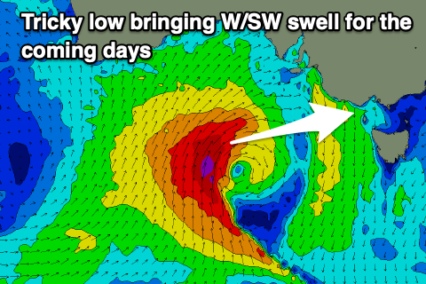
This week’s outlook revolves around the low that’s currently moving into the Bight, west of us, with it due to linger most of the week (strongest today) before shifting east and across us in a diminished form on Thursday/Friday.

This will then only be replaced by a similar system on the weekend, with this second low looking even worse for swell production in our region.
Firstly, the current system has deepened overnight south of Western Australia, with gale to severe-gale force winds wrapping around its core, but the alignment is not ideal for swell generation in Victoria at all. It’s north south to north aligned, with all the energy being aimed up into South Australia.
In saying this the strength of the core winds is impressive and just within our swell window, with moderate levels of mid-period W/SW swell energy spreading radially out towards us from the strongest stage of the low today.
It’s due to build through tomorrow, peaking into the afternoon and then ease steadily through Wednesday thanks to the low easing quickly in strength today.
Size wise, the westerly nature will limit the Surf Coast to an inconsistent 3ft+ tomorrow afternoon with 4-5ft+ sets to the east, easing quickly from 2-3ft and 3-5ft respectively on Wednesday.
Thanks to the low sitting west of us we’ll see strong N-N/NE winds through tomorrow, favouring the beaches over the reefs while a shift to the N/NW is due through Wednesday as the swell eases.
Thursday looks smaller as the remnants of the low move across us, bringing W’ly winds and some weak W/SW energy to 2ft+ on the Surf Coast and 3-4ft to the east, easing back through Friday.
Winds will accordingly swing from the NW to W/NW on Thursday with N/NW tending stronger N winds due into Friday as the next low starts to move in from Western Australia.

Now, at this stage this secondary low looks even poorer for swell generation across our region with it being focussed more into the Western Australian region, leaving no real swell for us at all.
The question is, with all this mid-latitude activity blocking up our main Southern Ocean swell window, when will we see a return to some proper frontal activity?
At this stage there’s no sign of it across our region but we should see increased activity to the south-west of Western Australia from next week, bringing some better but inconsistent W/SW groundswell energy from later next week. More on this in the coming updates.


Comments
Yesterday was well and truly worth it on the beaches to the west…I didn’t risk my back heading to the east which was the right call I reckon! Super fun 3 footers coming through
Good to hear!
Does this pattern ring a bell?
Ground hog day
https://open.spotify.com/track/2VhxVPr5V6eXE2tnwadAR0?si=1UvGctK0RO2TVCn...
Cmon craigos!
I'll take offshores for a week even if it is on the small side. At least you can find a surf without too much difficulty.
Agreed if you aren’t on the surfcoast
The swell today is pretty big , I was surprised to see when I checked this morn my local spot wild and closed out.
Nice nothing really showing in Vic yet.. Flukey source.
great morning on the limestone coast, when the sun came out,
we got to explore some fave breaks that only go with decent swell and a stiff northerly..
(same swell lines sth of adelaide by the looks on cams atm)
I know them well, good work!
Tuesday was all time at my local go to normally mush burger reef point.
Something about that swell direction that turned it into a .....watu type wave.
The quick jump in swell caught everyone off guard and had it to myself the first hour.
Been surfing this wave for 50 years and I rate Tuesdays session in my top 5 at this break for a number of factors.
Very interesting, I'd say swell direction wise it was just north of west if you get my drift. Maybe pushing in with more wall with those 'north' sets?