Fun Sunday, tricky west swells for next week
Victorian Australian Surf Forecast by Craig Brokensha (issued Friday June 21st)
Best Days: Sunday, Monday morning exposed breaks, selected spots Tuesday afternoon through Thursday
Features of the Forecast (tl;dr)
- Peak in W/SW swell this afternoon, easing tomorrow with mod-fresh S-S/SE winds (likely variable early to the west)
- Moderate sized W/SW groundswell arriving later tomorrow, peaking Sun AM, easing
- Local offshore winds Sun AM, tending N/NE into the PM
- Fading swell Mon with strengthening N/NE winds
- Tricky, building W/SW swell Tue PM, peaking Wed, easing Thu with N/NW winds
Recap
The surf was small to tiny yesterday and best to the east with clean conditions for most of the day.
Today we’ve got some new W/SW swell on the build but with onshore winds across all locations, creating average conditions.
This weekend and next week (Jun 22 - 28)
Looking at the weekend ahead and Sunday is the pick, with tomorrow offering easing levels of swell from today along with moderate to fresh S-S/SE winds. There’s a chance for variable winds on the Surf Coast in the morning but it looks small and easing from a lumpy 2-3ft, 4-5ft to the east.
On Sunday though a fun pulse of new W/SW groundswell is due, with it arriving later tomorrow but peaking through the following morning.
The source has been a good fetch of strong to gale-force W/NW winds moving in from the Indian Ocean tracking east-southeast through our swell window.
We should see a fun kick in size Sunday morning to 2-3ft on the Surf Coast and 4-5ft to the east along with favourable local offshore winds (N/NW Surf Coast, N/NE to the east), tending N/NE into the afternoon across all locations as the swell eases.
The swell will continue to fade into Monday with strengthening N-N/NE winds favouring selected spots.

As touched on in the forecasts earlier in the week, the rest of next week looks generally slow and tricky thanks to no outstanding storm activity through the Southern Ocean.
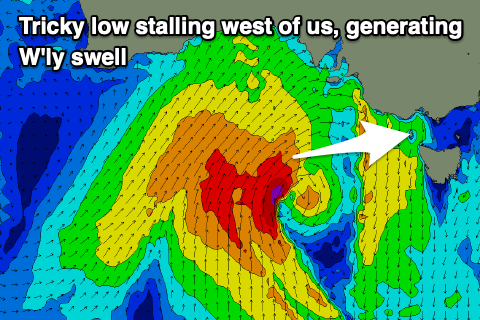
Instead we’ll see a very funky mid-latitude low meandering in from the west during the weekend and next week, with it due to stall in the Bight while strengthening through Monday.
The alignment of the low longs latitudinal, ie south to north and at this stage all the energy looks to be aimed up into South Australia, with minimal levels of energy spreading through our western swell window, less so again into the Surf Coast.
At this stage expectations should be kept on the low side until we can get a clearer idea on the makeup of the low and swell potential for us on Monday.
Any swell looks to build through Tuesday and peak Wednesday under favourable N/NW winds as the low stalls west of us.
The low looks to move across us later in the week but with no strength, with clean conditions but small surf due to continue.
Following this the outlook remains slow with favourable winds for the exposed beaches and no major Southern Ocean activity. More on this Monday, have a great weekend!


Comments
Expectations on the low side won’t be a problem
Meanwhile, on the East Coast.........
"The swell will continue to fade into Monday with strengthening N-N/NE winds favouring secreted spots."
Secreting some hell pits I hope
Yes Yes TubbaBeezos!
Caught my eye too - Craigos what are you secreting!
Haha, oops.
It's been an Indian summer down here, preponderance of clear skies, little rain in winter - leading to cold overnight temps. Quite a lot of rain overnight broke this drought. Lack of winds have been giving the wind power generation a headache. At least there's a bit of snow on some of the resorts now
https://www.snowatch.com.au/live-snow-cams/
I guess east coast has been pumping like in last La Nina?
Actually not quite, not much east swell, just lots of good swells from the south and south-east.