Average couple of days, fun into Sunday
Victorian Surf Forecast by Craig Brokensha (issued Wednesday June 19th)
Best Days: Exposed beaches this afternoon for the keen, Sunday, Monday exposed beaches
Features of the Forecast (tl;dr)
- Fading swell tomorrow with N/NE winds
- Moderate sized W/SW groundswell for Fri with fresh S/SE tending S/SW winds
- Strong S-S/SE winds Sat with easing surf
- Fun, small-moderate sized W/SW swell for Sun AM, easing with N/NW tending N/NE winds to the west, N/NE all day to the east
- Easing swell Mon with N/NW tending N/NE winds
Recap
Lighter winds created cleaner conditions across most spots yesterday, though the Surf Coast was still a bit lumpy and to 2ft, better to the east and more so Phillip Island with clean 2-3ft sets.
Today the swell has backed off and we’ve got slow, inconsistent but clean 1-2ft waves on the Surf Coast, 2-3ft to the east again but a little wind affected. We should see winds improve for locations east of Melbourne into the afternoon but with a further drop in swell.
This week and next (Jun 20 - 28)
Looking at the days ahead, and the surf will bottom out through tomorrow as winds shift N/NE and hold all day ahead of an approaching trough which will move through the evening and bring average, fresh S/SE tending S/SW winds through Friday.
This will be as the swell generated by the earlier stages of the mid-latitude trough fills in. That being a moderate sized W/SW groundswell, generated by a good fetch of gales projecting up towards Western Australia, through our western swell window.
We should see 3ft+ waves on the Surf Coast with 4-5ft+ sets to the east, easing through Saturday as winds remain gusty from the S/SE.

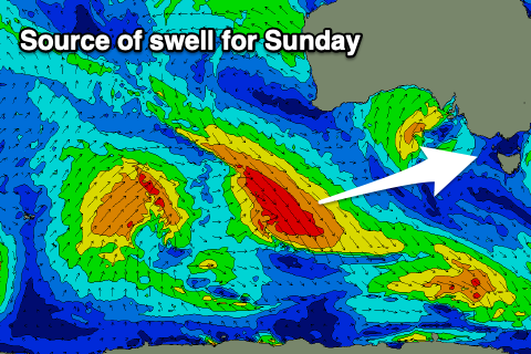
Into Sunday, a better, light, local offshore wind is due along with a new, mid-period W/SW swell. This looks fun and generated by a healthy low moving into the Southern Ocean from the Indian Ocean while generating a fetch of strong to gale-force W/NW winds.
2-3ft waves are due on the Surf Coast, 4-5ft to the east Sunday morning, easing through the day and further Monday with N-N/NW tending N/NE winds.
Unfortunately following this there’s nothing major on the cards at all thanks to funky mid-latitude systems continuing to meander in from the west. Winds look favourable for exposed breaks Tuesday, shifting more N/NW on Wednesday.
Later in the week we may see a fun new S/SW swell from a polar storm, but check back here on Friday for an update and any change to the current status quo.

