Tricky week and weekend
Victorian Surf Forecast by Craig Brokensha (issued Monday June 10th)
Best Days: This afternoon to the east, late tomorrow Surf Coast for the keen, Thursdsay Surf Coast for the keen, Friday and Saturday mornings to the east
Features of the Forecast (tl;dr)
- Small, mid-period S/SW swell tomorrow
- Moderate sized W'ly swell building later in the day with strong N tending N/NW and then W/NW winds
- Moderate + sized localised SW swell Wed with strong W/SW tending SW winds
- Moderate + sized, mid-period S/SW swell Thu with light to moderate SW-S/SW winds (likely W/NW early Surf Coast)
- Easing swell Fri with E/NE tending S/SE winds
- Smaller Sat with NE tending S/SE winds
- Small, inconsistent long-range groundswell Sun with strong S/SW winds
Recap
An average weekend of surf with small amounts of swell and no real offshore winds. Conditions were more lumpy into Saturday morning, bumpy yesterday as troughiness in the region resulted in no reliable offshore flow.
This morning we’ve got better winds across the Surf Coast that should also improve to the east after lunch and swing more N’ly along with a small, easing swell.
This week and weekend (Jun 11 - 16)
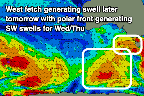
We’ve got a very dynamic but tricky week of winds and swell across the region as a mid-latitude low moving in from the west generates an initial, robust westerly fetch tomorrow, followed by a more significant polar front projecting up and into us Wednesday.
The mid-latitude low will bring strengthening N tending N/NW and then W/NW winds tomorrow but swell wise, it looks to be a tricky one. In the morning we may see a small, mid-period S/SW swell to the 2ft range on the Surf Coast, 3ft to the east, but into the afternoon, an unfavourably aligned fetch of strong to gale-force W/NW-W winds should generate some building mid-period W’ly swell.
I wouldn’t expect any real size until later in the day with sets possibly reaching 3ft on the Surf Coast on dark, bigger to the east but choppy.

Into Wednesday, strong SW-S/SW winds will generate some bigger mid-period SW swell, with the Surf Coast should build to 4-5ft through the day with 6ft+ sets to the ease, but winds will be strong from the W/SW tending SW, creating generally poor conditions.
The size will ease into Thursday, but the swell period will draw out, with the stronger energy generated by the earlier stages of the polar front, south of us today filling in.
It looks a bit weaker than forecast last week and as a result we’re looking at waves in the 4ft range on the Surf Coast Thursday, 6ft to the east and with weaker SW-S/SW winds.
There’s an outside chance for an early W/NW breeze on the Surf Coast but it’ll still be lumpy and not ideal.
Now, the wind outlook from Friday into the weekend and early next week depends on how the remnants of the mid-latitude low and polar front evolve once moving into the Tasman Sea.
Both global wave models have it forming into a broad low across the southern Tasman Sea, even possibly retro-grading back to the west and what this means is dicey conditions for us until it fully clears to the east or weakens.
With this in mind expect the wind outlook to change quite a bit over the coming week, though we should see light E/NE breezes Friday morning with easing levels of mid-period swell from 3ft+ on the Surf Coast and 4-5ft+ to the east.
Saturday looks smaller along with variable NE winds, with onshores possible kicking back in for Sunday.
Swell wise, small levels of long-range energy are due Sunday, with nothing of significance through early-mid next week owing to high pressure sitting west of us with the low to our east. More on this Wednesday.


Comments
Surely TubbaBird will be on the rinse looking at this forecast. Good to see Craigos keeping the frothers up to date! Love your work 'os.
Heard there's epic banks at Mysto's down by the old carrie. Get on it
Xaivier Huxtable the only Victorian getting waves this week! 20 point perfect heat at Nias - well done
Yeah, far out. That was fucked up.