Make the most of the coming windows of surf
Victorian Surf Forecast by Craig Brokensha (issued Friday May 31st)
Best Days: Later today, tomorrow, Monday exposed beaches, Friday exposed beaches
Features of the Forecast (tl;dr)
- Moderate + sized spike in W/SW swell later today with W/NW winds, easing tomorrow with W/NW winds, tending light-mod S into the PM
- Smaller Sun with increasing S/SE winds
- Small Mon with E/NE tending N/NE then N/NW winds
- Possible small spike of W/SW groundswell Mon PM, easing Tue with W/NW tending SW winds
- Inconsistent, moderate sized W/SW groundswell Tue PM, easing Wed with early W/SW tending mod-fresh S/SW winds
- S winds Thu, with an inconsistent SW groundswell for Fri with variable offshore tending SE winds
Recap
Clean conditions with good, easing levels of W/SW groundswell from Wednesday, down from 2-3ft on the Surf Coast and 4-5ft to the east.
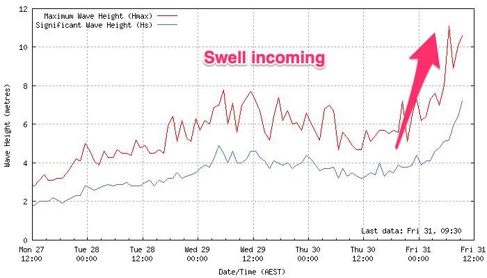
The swell has bottomed out this morning but a rapid jump in close-range W/SW swell is due this afternoon, outlined in more detail below.
This weekend and next week (Jun 1 - 7)
A strong mid-latitude low is currently barreling in from the west and with it, we’re due to see a fetch of W/SW gales pushing in from the west, generating a strong swell front that’s due to arrive into this afternoon. The Cape Sorell wave buoy is on the way up (below left) and we should see a moderate + sized pulse of W/SW swell later afternoon, reaching 4-5ft on dark on the Surf Coast and 6-8ft to the east as winds shift W/NW.

The swell will ease through tomorrow back from 4ft on the Surf Coast and 6ft to the east as winds remain light from the W/NW, shifting S’ly into the afternoon but only light to moderate in strength.
This is thanks to the trough that was expected to bring a change now looking to strengthen more into the evening, bringing strengthening S/SE winds on Sunday with the size dropping away more.
We should see the trough drifting back to the west through Monday and this will swing winds E/NE to N/NE and then N/NW but swell wise, we’ve got nothing really of size due with small 1-2ft leftovers on the Surf Coast, 2-3ft to the east. There’s a chance for a small flukey pulse of new W/SW swell into the afternoon but don’t count on it, easing Tuesday with W/NW tending SW winds as the trough drifts back east across us.
This will spoil a new, inconsistent W/SW groundswell that’s due to build into Tuesday afternoon, peaking later and then easing Wednesday.
Winds look to remain moderate to fresh from the S/SW, possibly W/SW for a short period early in the morning but overall not worth chasing hard.

Looking at the swell and it’s being generated by a strong progression of mid-latitude frontal systems pushing up towards Western Australia in our medium to long-range swell window.
With this we’re only expecting moderate sized surf with inconsistent sets building to 3ft into the afternoon on the Surf Coast, 4-6ft to the east, then easing Wednesday from a similar size.
Unfortunately it looks like winds will linger out of the S’th as the swell eases Thursday, back offshore Friday with a longer-range, less consistent and small W/SW groundswell likely.
Beyond this the outlook remains slow but check back here on Monday for the latest. Have a great weekend!


Comments
Holy fark.
Sharknado at 11:16;45 on Winki Pop Cam.
Directly beyond the pack at Uppers, half way to the horizon.
Keep your eyes peeled folks.
Wow incredible!
Thanks Kidkaos!
It's almost southern right whale time so more noahs now?
Good thing there’s a camera at Winki for citizen science purposes
BOM saying South Westerlies/ Westerlies for Mon Tues Weds
Hi Craig, is there a change to the wind outlook on Monday?
Agh yes there is. Due to the tricky nature of the axis of this low. Now looks onshore from the SSW to SW unfortunately.
OK will stay away from the granite and head to the volcanic
has anyone got a link to this proposed water park development in se melbourne. that is not blocked by a paywall. thanks in advance pigdog
There's this:
https://engage.vic.gov.au/planning-scheme-amendment-c222king-321-old-dan...
thanks spinafex.
?si=ezmE3rmJ3fe3_dnpwhat is "ES3200" SPECS . wave tec???
is it this