Stalling trough brings better conditions today
Victorian Forecast by Craig Brokensha (issued Friday May 24th)
Best Days: Every day (including today) this period will have a decent wave
Features of the Forecast (tl;dr)
- Moderate sized mid-period SW swell building today, peaking into the afternoon, easing tomorrow
- Light-moderate E/NE-NE tending E winds tomorrow
- Smaller Sun with local offshore winds
- Inconsistent SW groundswell for later Sun, peaking Mon AM, easing
- NW tending variable winds Mon
- Smallish, inconsistent W'ly swell Tue with N/NW winds, tending N/NE to the east into the PM
- Mod-large sized W/SW groundswell Wed AM, easing with strong N'ly winds (tending N/NW to the west and N/NE to the east)
- Easing swell Thu with strong N tending weaker N/NW winds
Recap
The surf dropped away through yesterday with small, fun waves across the Surf Coast, best in the morning.
Today we’ve got a tussle between a building mid-period SW swell and tricky trough in the region, and latest updates have the trough being weaker and slower moving.
What this means is that the change only looks to impact the Torquay and further west locations from mid-late morning, with lighter more variable winds to the east. We should see the new swell build to the 4ft range on the Surf Coast and 6ft to the east offering plenty of quality waves into the afternoon.
This weekend and next week (May 25 - 31)
This afternoon’s good pulse of mid-period SW swell should start to ease through tomorrow, down from 3-4ft on the Surf Coast and 5-6ft to the east.
With today’s trough being weaker and less influential, we’ll see winds tend back to the E/NE-NE tomorrow morning (light to moderate), favouring selected spots, tending variable E into the afternoon.
Sunday looks smaller but with favourable, local offshore winds holding all day, N/NW to the west and N/NE to the east.
Now, later in the day Sunday but more so Monday, a new, inconsistent SW groundswell is due, generated by a strong but distant polar low that traversed under the Indian Ocean through this week.
Slow but good 2-3ft sets should be seen on the Surf Coast, 4-5ft to the east, easing slowly through the day and with a moderate to fresh NW’ly tending variable wind.
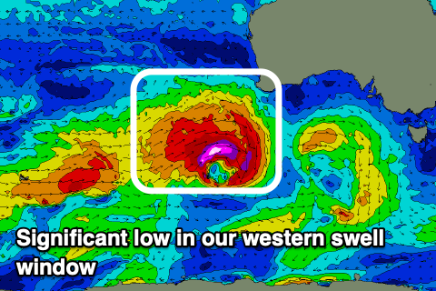
We then look at the tricky, W’ly swells due from Tuesday through the end of next week across the state, generated by a flurry of strong mid-latitude frontal systems pushing through the southern Indian Ocean, towards and then under Western Australia.

As touched on in Wednesday’s notes, the progression is great but the location isn’t with all the activity falling within our western swell window.
This will result in less consistency and size across the sheltered Surf Coast which will be the cleanest.
Tuesday’s swell will be generated by the weakest of the incoming systems, with an initial fetch of gales due to weaken when pushing close to Western Australia tomorrow.
It’ll be inconsistent with 2ft to occasionally 3ft sets due on the Surf Coast magnets, 4ft+ to the east along with N/NW tending variable winds on the Surf Coast and N/NE winds into the afternoon to the east.
Similar but strengthening winds are due into Wednesday and this will be along with a stronger pulse of W’ly groundswell.
A strong low forming in the eastward progression of fronts this weekend should generate a great fetch of severe-gale to storm-force winds through our western swell window, producing a tricky, moderate to large sized W’ly groundswell.
The Surf Coast should come in around 4-5ft (possible rare bigger one magnets), but with long waits between sets, 8ft to the east (we'll confirm this Monday), easing into the afternoon and further Thursday from 3ft and 4-6ft respectively west and east of Melbourne.
Strong N’ly winds are due Thursday morning, shifting N/NW into the afternoon, NW tending W/NW next Friday with a possible new close-range swell. More on this Monday though. Have a great weekend!


Comments
coo coo ka choo
looking at the 16 day long range you can see the weather pattern for winter almost perfectly comes in on cue at the start of the season. The past few days the weather has been superb and also this is easily the most comfortable may water temps I've ever felt. Last year winter was easy to handle too only getting numb feet once coming in after a surf.
