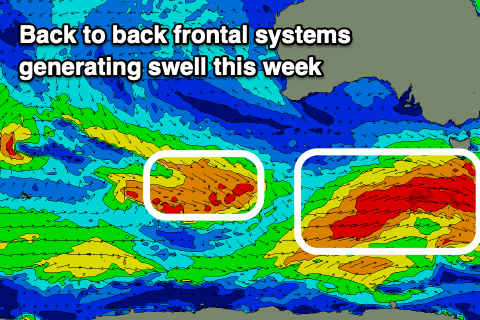
Much better surf later week
Victorian Forecast by Craig Brokensha (issued Monday May 13th)
Best Days: Thursday, Friday morning, Saturday, Sunday morning
Features of the Forecast (tl;dr)
- Small, weak W/SW swell tomorrow with W/NW tending W/SW-SW winds
- Slightly better W/SW swell for Wed with NW tending W/NW winds, S/SW later
- Moderate + sized SW groundswell building Thu with N/NW tending W/NW winds
- Easing swell into Fri AM, ahead of a secondary slightly stronger pulse of SW groundswell into the PM and Sat AM
- Moderate W/NW tending fresher SW winds late AM Fri, S/SW into the PM
- Light S/SW winds Sat (likely W/NW early Surf Coast)
- Moderate + sized S/SW swell building Sun PM, easing Mon
- Moderate W/NW tending fresh SW-S/SW winds Sun, moderate S/SW Mon
Recap
A mix of easing S/SW groundswell and localised SE windswell on Saturday, fading further into yesterday. Locations east of Melbourne performed best but when cleanest yesterday, back to small and weak. The aurora australis put on a better show into Saturday evening, wowing those down on the coast.
This week and weekend (Apr 14 - 19)
Following the run of east winds and S/SW swells, there is a change in patterns afoot as the strong, dominating high pressure linked to last couple of weeks of waves is now moving off to the east, replaced by relatively weak frontal activity under the country.
It’s this activity which will generate some weak W/SW swell over the coming days, with stronger fronts due to fire up from tomorrow through the rest of the week, generating a bit more size through Thursday onwards. Winds will become a slight issue, though we’ll discuss this in more detail below.
The current shift in winds is thanks to a weak front moving in and this looks to generate a weak 2ft or so of swell for the Surf Coast tomorrow with 4ft surf to the east with a light to moderate W/NW tending W/SW-SW breeze.
A secondary pulse of mid-period W/SW swell is due Wednesday, likely coming in a little stronger than tomorrow’s with 2ft+ sets on the Surf Coast and 4ft+ waves to the east along with a NW tending W/NW breeze, shifting S/SW later.

Of greater importance is the moderate + sized SW groundswell for Thursday, with it being generated by the first of the more significant storms passing under the country tomorrow. A great fetch of strong to gale-force W/NW winds, followed by post-frontal W/SW winds of similar strength should generate a prolonged swell through Thursday and Friday.
The Surf Coast should build to 4-5ft through Thursday with 6ft+ sets to the east, easing back temporarily from the 4ft range to the west and 6ft respectively to the east on Friday morning.
Into the afternoon, our next pulse of SW swell is due, generated by a secondary similar structured frontal system moving in under the country Wednesday and Thursday.
It could be a touch stronger, and while working on an active sea state we will likely see 4-5ft+ sets on the Surf Coast later Friday afternoon and early Saturday with 6ft to possibly 8ft sets to the east.
Looking at the local winds and a N/NW offshore will only shift light W/NW into the afternoon on Thursday, creating great conditions with Friday due to see morning W/NW winds, shifting SW later morning and then S/SW into the afternoon in the wake of the second swell generating front.
Saturday looks dicey with lingering S/SW winds in the wake of Friday’s change, but without any major strength conditions should be OK. With this the Surf Coast will likely see an early W/NW breeze.
A third system is expected to follow a similar track to the first two through Friday and Saturday, with another pulse of moderate + sized pulse of swell due into Sunday afternoon/Monday morning but with less favourable winds, swinging from W/NW to S/SW on Sunday and then moderate S/SW Monday.
We’ll have a closer look at this on Wednesday.


Comments
Praise thy Craig, the sacred messenger of Poseidon
lol
Amen F'man
For those on the Surf Coast this is a great forecast compared to the last two weeks. May is usually one of our best months of the year for surf. Hopefully the rest of the month can deliver.
I thanks and praise you Craig for your marvelous wonders. I thank you for these brand new days of swell and offshore wind. I will bless your name at all times, and my lips will speak of your works. Amen! Also, special shout out to Huey.
Amen!
Well put Tubster! May the lord be with you.
Craigos you emissary of light, you! A forey of biblical proportions no less.
Tremendous forecast
Praise Craigos
I'm sure crowds will be low on the surf coast, everyone's had plenty lately...
All hail craigos
Craigo: Westernport Thursday morning best for us 'Ninchers? Is that what I'm yoda'ing?
Looks like the NW will be too strong for the open beaches down here prior to the swell jacking up.
Have fun team, and play nicely ;)
Give it to me Craigy!
You're all a 'orny bunch aren't ya. Ha!
Now you're talkin' Craig.
They are going to be wondering where the fuck I am on the jobsite later this week.
Time to make an appointment with Doctor Howmany. On ya Craig.
Not to ruin the vibe - Is there any chance of a return of a similar pattern that we've seen the last few weeks - please say no, I'm looking forward to making up for lost time in the second half of May.
"Following the run of east winds and S/SW swells, there is a change in patterns afoot as the strong, dominating high pressure linked to last couple of weeks of waves is now moving off to the east, replaced by relatively weak frontal activity under the country."