Improving surf from Friday, with favourable winds for the beaches
Victorian Forecast by Craig Brokensha (issued Wednesday March 6th)
Best Days: Keen surfers Friday from mid-late morning, Saturday, Sunday morning exposed breaks, Monday morning
Features of the Forecast (tl;dr)
- Small to tiny tomorrow with moderate S/SE winds
- Moderate sized W/SW swell for later tomorrow, but more so Fri AM with pre-dawn SE winds, tending E/NE-NE through the morning aehad of S/SE sea breezes
- Easing swell Sat with NE tending fresher N/NE winds (likely N/NW mid-late PM to the west)
- Smaller Sun with N tending S/SW winds mid-late AM
- Moderate sized + W/SW groundswell for later Sun, peaking Mon with variable N winds ahead of a S/SW change
- Easing swell Tue with S/SE winds
Recap
Monday’s large S/SW groundswell eased back into yesterday as conditions improved across most locations though favoured the beaches to the east, still coming in at 4-6ft on the sets with lumpy 3-4ft waves on the Surf Coast.
This morning the surf is smaller but clean with 2ft leftovers both east (odd bigger set) and west of Melbourne. A trough will bring an onshore change by mid-morning, strengthening into the afternoon.
This week and weekend (Mar 7 - 10)
Tomorrow will be a lay day as moderate S/SE winds persist in the wake of today’s change, along with a low point in swell.
Later in the day some new mid-period W/SW swell energy may be seen, but the peak is due through Friday morning, with it generated by a distant but good fetch of strong to gale-force W’ly winds to the south-west of Western Australia on the weekend and earlier this week.
The swell should come in Friday morning to 3ft+ across the Surf Coast (4ft sets on the magnets) with 4-6ft surf to the east, easing a touch into the afternoon and then down further from 3ft and 4-5ft respectively Saturday morning.
Conditions on Friday morning look a little less than ideal with SE winds due right up until dawn, shifting E/NE-NE through the morning and then S/SE into the afternoon. This will see a lot of lump across all locations, with Saturday coming in better with NE tending fresh N/NE winds, possibly even tending N/NW to the west through the afternoon.

Sunday will be smaller again and there looks to be a window of N’ly winds ahead of a trough and S/SW change later morning.
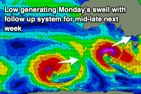
Into next week, a strong pulse of W/SW groundswell is due into Monday, with a mid-latitude low due to fire up under the Bight, drifting east-southeast while deepening. The low looks quite intense with a fetch of severe-gale to possibly storm-force W/SW winds moving through our western and then south-western swell windows.
This should produce a strong pulse of swell for later Sunday but more so Monday to 4ft+ on the Surf Coast and 6ft to occasionally to 8ft to the east. There’s room for movement in the size depending on the strength of the low but we’ll review this Friday. Winds look favourable and variable tending locally offshore Monday morning, onshore Tuesday as a trough pushes through.
Beyond this more strong pulses of swell are due mid-late week but with S/SE winds, more on this Friday.


Comments
Banger of a long weekend forecast!
Gona be a zoo on the open beaches Saturday with surfers/non surfers alike- hopefully enough banks to spread the punters out.