Large swells to come but improving as it eases
Victorian Surf Forecast by Craig Brokensha (issued Friday February 23rd)
Best Days: Sunday morning, Tuesday morning to the east, Wednesday to the east
Features of the Forecast (tl;dr)
- Large W/SW groundswell for this afternoon, with a large reinforcing pulse of S/SW energy tomorrow morning
- Fresh S'ly winds, easing into the PM
- Easing S/SW swell Sun with local offshore N winds, tending S'ly into the PM and freshening later from the S/SW
- Building W/SW swell Mon PM, easing Tue with S/SW tending gusty S/SE winds Mon, E/NE-N/NE tending SE winds Tue
- Small, background swell Wed with N/NE winds, strengthening later
- Strong run of swell from later next week into the weekend and beyond
Recap
The exposed beaches to the east still offered some fun surf yesterday morning before winds picked up out of the N'th and shifted, with slow but good 2-3ft sets, tiny to the west.
An afternoon change has shifted more west into this morning but with small, weak levels of local windswell.
Our large W/SW groundswell has hit the Cape Sorell wave buoy, with a sharp J-curve showing on the wave height recordings, but the large gap between the peak periods (16s) and average period (10s) show's there's a lot of windswell contamination in those readings.
Regardless we're on target for the Surf Coast to reach 6ft this afternoon but with strong SW-S/SW winds.

This weekend and next week (Feb 24 – Mar 1)
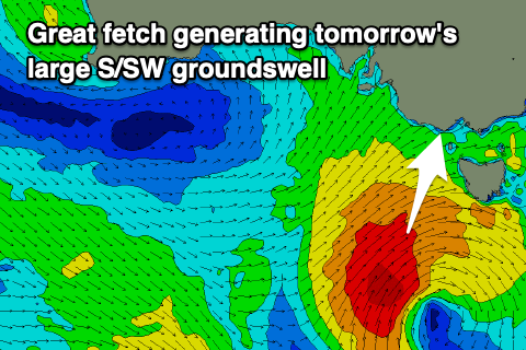
This afternoon's large pulse of W/SW groundswell energy was generated by the most intense stages of a significant low that formed south of the Bight mid-week. The low has since weakened but is generating a fetch strong to gale-force SW winds in our south-western and southern swell windows, generating large, reinforcing levels of SW tending S/SW swell into tomorrow.

Unfortunately a high moving in behind the low will bring poor S'ly winds, fresh in nature, easing through the afternoon. Size wise the Surf Coast looks to still be 6ft (likely rare bigger one magnets early), with 8ft sets to the east, easing through the day.
Sunday is still the pick as winds shift around to the N'th, locally offshore across all regions, tending S'ly early afternoon with a trough, then strengthening from the S/SW later.
The Surf Coast should ease back from 3ft+ with 4ft+ sets to the east.
The swell will reach a low point Monday morning and winds look to linger out of the S/SW, shifting S/SE through the morning and then strengthen through the day.
Our small lift in mid-period W/SW swell is still on the cards, generated by a broad but not overly strong fetch of W/SW winds to the south-west of WA yesterday and today.
A kick to 2ft to occasionally 3ft is due on the Surf Coast, easing Tuesday from a similar size with 4ft sets to the east. Winds should swing back to the E/NE-N/NE on Tuesday morning favouring the beaches ahead of sea breezes.
Wednesday should still be fun with background levels of swell maintaining 2ft sets on the Surf Coast, 3-4ft to the east with great N/NE-NE winds, strengthening later in the day ahead of a SW change through Thursday.
As touched on in Wednesday's update, the longer term outlook is very active with the Southern Ocean storm track due to fire up through next week and into next weekend, bringing a moderate to large run of swell with what looks to be periods of favourable winds for both regions. Exciting!
More on this Monday. Have a great weekend!


Comments
That does sound exciting will look forward to that. Though after a poor Nov, Dec, Jan, Feb was really not too bad with some good sessions each week at a few different locations.
"periods of favourable winds for both regions" - to whisper of a dream
When you’re excited Craigos, I’m excited
I feel like the term 'active' has been missing from the forecasts for some time!
13th Beach Rd closed Sunday morning from Barwon Heads to Black Rock Rd until mid-morning for triathlon.......
Also Jan Juc beach closed from Bird Rock to Steps due to cliff safety risk. https://timesnewsgroup.com.au/surfcoasttimes/news/cliff-danger-alert-jan...