Trickier period ahead of a likely stronger swell late next week/weekend
Victorian Surf Forecast by Craig Brokensha (issued Friday February 16th)
Best Days: This morning, tomorrow morning for the keen, Tuesday morning on the beaches to the east
Features of the Forecast (tl;dr)
- Small mix of new mid-period SW swell Sat, and inconsistent SW groundswell late Sat/Sun
- Moderate S/SE winds tomorrow, easing later morning and then freshening again later
- Variable winds early Sun AM to the west, lingering S to the east, freshening from the S/SW into the PM
- Moderate sized mid-period SW swell building Mon, peaking in the PM with moderate S/SE winds, freshening from the S-S/SW
- Easing swell Tue with E/NE tending S/SE winds
- Small, fading swell Wed with E/NE-N/NE tending S/SE winds
- Tiny Thu with strong N/NE tending SW winds
Recap
The surf remained strong yesterday as a better, mid-period SW swell filled in with variable winds. Conditions were a little lumpy in selected spots but generally favourable with 3-4ft waves on the Surf Coast and 5-6ft sets to the east.
The swell has eased back a little this morning and conditions are favourable for the beaches with a bit of east in the wind, light enough for the Surf Coast and good to the east.
This weekend and next week (Feb 17 - 23)
The weekend looks fun swell wise, but the local winds are the main issue, not ideal but workable.
Our current swell ease though be replaced by some reinforcing energy, hold in the 2-3ft range tomorrow on the Surf Coast and 4ft to the east, thanks to weak frontal systems passing under the country in the wake of Wednesday's front.
Winds will be a little less favourable than this morning though with a moderate S/SE breeze, easing into the late morning which should see conditions improve. Freshening S'ly winds will then be seen into the afternoon so surf before then.
On Sunday, a long-range and less consistent groundswell is due, generated by a distant polar low. This should maintain similar sized surf Sunday but with a wait for them along with lighter, possibly variable winds to the west, lingering S'th to the east. Lower your expectations again and you should find a couple.
Unfortunately the start of next week looks average, with freshening S/SW winds into Sunday afternoon due to swing more S/SE and persist Monday though only moderate in strength. A new pulse of mid-period swell for Monday looks a touch smaller now, with the strengthening frontal system linked to it, passing under the country on the weekend, now looking a bit weaker.
We should still see a a kick in size during the afternoon to the 3ft range on the Surf Coast through the day with 4-5ft sets to the east but with freshening S-S/SW winds.

Tuesday looks better for the beaches as the swell eases from 2-3ft and 4ft respectively with an E/NE offshore ahead of S/SE sea breezes.
Following this the outlook becomes slow with easing surf into the middle to end of the week with an E/NE-N/NE offshore due Wednesday morning, tiny Thursday as winds become strong from the N/NE.
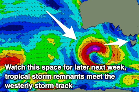
Longer term, the strengthening winds on Thursday will be ahead of a significant low deepening under the country, with the catalyst for it being a tropical cyclone drifting from the Indian Ocean into the Southern Ocean storm track. We'll have a closer look at this and the swell possibilities on Monday. Have a great weekend!


Comments
Bit of mayo on todays report?