Trickier period but with windows of OK surf
Victorian Surf Forecast by Craig Brokensha (issued Monday February 12th)
Best Days: Now on the beaches, tomorrow morning exposed beaches, Thursday morning for the keen, Friday morning for the keen to the east
Features of the Forecast (tl;dr)
- Small-mod sized mid-period S/SW swell for later today, holding tomorrow morning then easing
- Strengthening N/NE winds to the east, N/NW to the west ahead of a strong PM S/SW change
- Moderate sized local SW swell for Wed with gusty W/SW-SW winds, tending S/SW
- Slightly stronger, inconsistent mid-period SW swell for Thu with light-mod S/SE winds, freshening
- Easing surf Fri with light E/SE tending S/SE winds
- Smaller Sat with mod-fresh SE winds, S/SW Sun
Recap
Generally poor conditions across most of the region Saturday with a large, building S/SW groundswell that peaked into the afternoon/evening along with local levels of SE windswell.
Yesterday provided cleaner but still lumpy conditions across selected spots with a steady drop in S/SW swell energy along with the SE swell still in the water.
The Surf Coast eased back from a lumpy 3-4ft, with 4-6ft sets to the east, cleaner this morning and back to 2ft and 3ft respectively. A trough will bring a shallow S/SW change soon which will freshen into the afternoon.
This week and weekend (Feb 13 - 18)
Today's increasing S/SW winds will spoil a late pulse of new mid-period S/SW swell expected across the state, though tomorrow should be super fun and lined up with a strengthening N/NE wind to the east, N/NW to the west ahead of an afternoon S/SW change.
Size wise the Surf Coast looks to be mostly 2ft tomorrow morning (2-3ft magnets), easing through the day with easing 3-4ft sets to the east.
Fresh to strong W/SW-SW winds will persist into Wednesday but with a weak, building windswell thanks to a broad though relatively weak frontal system pushing up and into us.
There's a good chance for early W/NW winds on the Surf Coast but the swell will be low in quality, likely to 3ft+ or so. The peak in energy doesn't look much better with 3ft to possibly 4ft sets due into the afternoon on the Surf Coast, 5ft+ to the east.

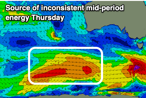
Thursday should see more distant, stronger swell energy generated by the earlier stages of the frontal system when strongest on the polar shelf (left), maintaining surf in the 3ft+ range on the Surf Coast and 4-6ft to the east but with light to moderate S-S/SE winds. Not ideal but worth a punt.
A slow improvement in conditions is expected on Friday as winds shift light E/SE in the morning with weak, fading mid-period swell energy from 2-3ft on the Surf Coast and 4ft+ to the east.
Into the weekend we're unfortunately looking at persistent SE winds and fading surf as a high sets up camp west of us, keeping any major swell generating systems at arms length from the region.
There doesn't look to be any break in this setup until later in the month so try and make the most of the small windows of surf this period.


Comments
I was very pleasantly surprised at the quality of the waves and size (even though Craig did say 2 to 3 ft on magnets) this morning on the SC considering the Cape Sorrel and Pt Nepean bouys weren't really showing much I thought.
Awesome.
It was bloody fun. Couldn’t help sweating looking at how many were in full steamers…felt tropical out there this morning.
What was with all the butterflies?
White ones?
Last couple of weeks they’ve been everywhere.
https://au.news.yahoo.com/residents-stunned-as-alarming-sight-sweeps-ove...
Heard the name Cabbage Moth but didn't know they were a problem. Seen them around a bit recently, but yesterday there was heaps! Even out on the water when that wind shifted from the North. Can't imagine they get much say when the wind is as strong as it was yesterday.
Bit of chaos with the strong change this arvo?
This part of the coast didn't see too much in the way of rain or damaging winds. Looked pretty wild around parts of Greater Melbourne though. Transmission lines down near the You Yangs, sizeable hail for bayside suburbs and damaging winds for many other suburbs (plus sideways rain).
The classic storm split over the Peninsula. Pretty cool seeing the storm clouds materialise so quickly around lunchtime.
I was in the water when one of the squalls came through.
Pretty wild being in the water with that amount of wind and surfing in boardies too!