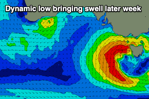
Dynamic period but with good windows
Victorian Surf Forecast by Craig Brokensha (issued Monday January 14th)
Best Days: Now beaches, tomorrow morning on the swell magnets, Surf Coast Thursday and possibly early Friday, Saturday morning
Features of the Forecast (tl;dr)
- Small, easing mix of SE windswell and background S/SW swell tomorrow with strengthening NE tending N/NE winds, easing later but holding N/NE-NE
- Tiny Wed with W/NW-NW tending strong S/SW winds
- New, moderate sized mid-period S/SW swell Thu AM with strengthening W/NW winds
- Larger localised SW swell building into the PM Thu with strong W winds
- Easing large S/SW swell Fri with mod W/SW tending S/SW winds (possibly W-W/NW early)
- Easing swell Sat with variable winds ahead of a S/SW change, S/SE Sun
Recap
Poor surf on the weekend as S'ly winds moved in following a trough Saturday morning, strengthening into the evening and choppy yesterday with no sizeable surf.
Today is much better to the east with a background S/SW swell to 3-4ft, junky to the west with some building SE windswell. Winds are favouring the beaches to the east though will revert back to the SE this afternoon and strengthen while kicking up a further increase in windswell.

This week and weekend (15 - 21)
We've got a very dynamic week of surf and weather ahead with a polar front due to combine with a mid-latitude low drifting in from the west, stalling in our vicinity through the middle to end of the week.
This will bring windy, building surf with windows possibly opening up to the west while the east looks to becomes a stormy mess.
With that in mind, try and make the most of the surf on offer today across the exposed beaches and tomorrow morning.
Winds are due to swing NE tomorrow morning and then strengthen from the N/NE during the day as the mid-latitude low moves in from the west, holding from the N/NE-NE into the afternoon.
Swell wise, a mix of easing SE windswell from a peaky 2ft is due on the Surf Coast, 2ft to possibly 3ft to the east, small to tiny into the afternoon.
Wednesday will be a lay day with no swell left in the tank along with a shift in winds to the N/NW-W/NW through the morning, tending S/SW later morning and then strong into the afternoon as an arm of low moves in, across us.
The low is forecast to deepen directly west of Tasmania into Wednesday evening, directing a fetch of W/SW-SW gales through our south-western swell window on Thursday, kicking up a rapid increase in windswell and mid-period energy.

Ahead of this some new swell from the polar front projecting towards us is due on Thursday morning, coming in at 3ft to possibly 4ft on the Surf Coast and 5-6ft to the east.
Winds will be good and strengthening from the W/NW, shifting W into the afternoon as the localised swell builds.
We should see the Surf Coast reaching 6ft into the late afternoon/evening with 8ft surf to the east, dropping from a similar if not slightly smaller size on Friday morning as the low starts moving east.
With this movement to the east, less favourable W/SW winds are due on Friday morning, likely tending W-W/NW for a period in the morning on the Surf Coast before shifting S/SW-SW mid-late morning.
The surf will ease rapidly into the weekend and variable winds could provide fun waves on the beaches Saturday ahead of a trough into the afternoon and less favourable S/SE winds Sunday. We'll have a closer look at this and the size of the localised swell Wednesday as any changes to the position or strength will result in adjustments.
Longer term the outlook is quieter, but more on this Wednesday.


Comments
a horseshoe of fetch!