Workable window tomorrow morning, then poor most of next week
Victorian Surf Forecast by Craig Brokensha (issued Friday December 22nd)
Best Days: Tomorrow morning selected spots, Thursday morning
Features of the Forecast (tl;dr)
- Small-mod sized mid-period SW swell for tomorrow, easing Sun
- Mod-fresh E/SE tending stronger S/SE-SE winds tomorrow
- Moderate SE tending strong S/SE-SE winds Sun
- Strong SE winds Mon/Tue with a mix of stormy SE windswell and moderate sized SW groundswell
- Reinforcing, moderate sized mid-period SW swell for Wed, easing Thu
- Moderate S/SE tending S/SW winds Wed
- Variable winds Thu AM ahead of a strong S/SW change
Recap
Terrible conditions across most locations with a mix of easing SW swell and SE windswell along with strengthening E/SE tending S/SE winds. Selected spots to the east offered OK waves in the morning, smaller today with similar conditions.
This weekend and next week (Dec 23 - 29)
Looking at the weekend ahead and it looks like we’ve got more of the same due tomorrow morning, with a gusty E/SE breeze in the morning, shifting more S/SE during the day and deteriorating.
There should be some new mid-period SW swell in the water though, generated by a healthy frontal progression along the polar shelf, earlier in the week.
The exposed beaches to the east are due to come in at 4ft+ with 2-3ft sets on the Surf Coast, and we should see workable options in selected spots with the early winds. The afternoon looks poor everywhere as winds shift more S/SE-SE and strengthen.
Looking at Sunday and weaker SE breezes are due across all locations, with possible E/SE winds across Phillip Island for a period though swell wise the surf will be easing from the SW and SE.
It’s not looking great and tomorrow morning would be a better bet.
Moving into the Christmas week, and the deepening inland low doesn’t look to dip south as it was forecast earlier in the week, and with this we’re unfortunately due to see strong SE winds kick in on Monday, holding through Tuesday, whipping up a sizey SE windswell across the region.

There’ll be no quality to be found and it’ll also ruin another fun pulse of SW groundswell due into Monday afternoon and Tuesday morning.
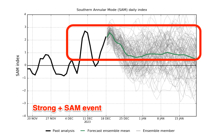
This run of poor weather and onshore wind is thanks to a strong + Southern Annular Mode event which sees the westerly storm track retract towards Antarctica (while strengthening), and higher pressure dominate the mid-latitudes.
There’ll be no real respite in the onshore flow as we transition from weaker S/SE winds on Wednesday morning, shifting S/SW through the afternoon as a small trough approaches from the west.

Thursday morning now looks like the best shot with possible variable winds in between onshore blows along with some fun, easing mid-period SW-S/SW swell energy.
The source will be a good fetch of strong W/NW winds moving under the country on the weekend, with a polar low generating an additional fetch of W’ly winds. This should produce a fun pulse of energy on Wednesday to 3ft+ on the Surf Coast, 4-5ft to the east, easing Thursday from 2-3ft and 4ft respectively.
Winds look variable in the morning before the next trough arrives, bringing strong S/SW winds and poor surf into next weekend. More on this Monday. Have a great weekend!


Comments
Well that's cheered me up no end
Wake me up when it’s Autumn please.
Dirty stuff Craigos, dirty stuff!
Merry Christmas Craigos!
Hopefully some SE swell for the Bluff in the New Year Tubba.
SAM staying positive til at least end of Jan.
George is getting upset!
Thanks for the pretty accurate forecasts during the year Craig!
My pleasure.
We can cope with some disappointing swell and winds through this period. But cold, wet, onshore wind and no waves is just flat out depressing. Especially when that is the forecast for basically the entire outlook.
So much for El Niño.
Getting pretty good at golf
I always wondered why people went to wave pools. Real waves are free and better after all.
After nearly two months in Victoria, I get why urbnsurf is so popular.
Unfortunately you couldn’t have picked a worse 2 months… whilst it’s often pretty ordinary at this time of year, the current run is as bad as it gets down here.
what happened to the strongest El Nino on record?