Fun swell with workable winds to end the week, windy and stormy from Sunday
Victorian Surf Forecast by Craig Brokensha (issued Wednesday December 6th)
Best Days: Today Surf Coast, tomorrow morning, Friday selected spots, next Wednesday morning and Thursday morning
Features of the Forecast (tl;dr)
- Moderate sized, mid-period W/SW swell for tomorrow and Fri AM, easing into the weekend
- Light, variable SE winds tomorrow AM, freshening through the day (light E/NE-E from PI east in the AM)
- Strengthening N winds Fri, tending NW mid-late PM ahead of an evening S/SW change
- Fresh S/SW winds Sat
- Moderate S tending strong SE winds Sun, holding Mon
- Moderate + sized SE windswell for later Sun and Mon
- Easing SE windswell Tue with a moderate + sized SW groundswell
- Fresh SE winds Tue
- Easing S/SW groundswell Wed and small SE windswell with NE tending SE winds
- Reinforcing SW swell Thu with N tending SW winds
Recap
The surf bottomed out through yesterday with onshore winds to the east, a little cleaner in protected spots on the Surf Coast but unsufable.
This morning we've got some new, inconsistent W/SW groundswell that's around 2ft on the magnets as we hit high tide. The swell should build to 2-3ft this afternoon but with bumpy conditions as winds shift S/SW-S through the day.

Slow 2ft sets this AM
This week and next (Dec 7 - 15)
Today's swell is the least consistent of what's expected over the coming days, generated in our far swell window (southern Indian Ocean) late last week.
Following this low, weaker but closer (in proximity) to us fetches of W/SW winds have generated some fun, reinforcing W/SW swell energy for tomorrow and Friday. It'll be weaker but should maintain more consistent 2-3ft waves on the Surf Coast, 4-5ft to the east along with workable winds.
Tomorrow morning won't be great but variable SE winds (tending E/NE from Phillip Island east) should create decent conditions for a paddle before stronger sea breezes kick in.
Friday morning will be cleaner and fun as the swell holds but starts to ease into the afternoon, with strengthening N'ly winds that now look to hold until mid-afternoon, shifting N/NW and then giving into an evening S/SW change.

This will be a two staged change, with winds due to go variable early morning before freshening from the S/SW again at dawn on Saturday, ruining the surf into the weekend.
Stronger onshore winds will then kick on Sunday as the trough bringing Saturday's change combines with a broader trough through the interior, strengthen across South Australia on this weekend.
This will bring strong SE winds, possibly lighter S at dawn but with no major swell, persisting on Monday out of the SE, kicking up a moderate + sized SE windswell.
The trough is actually expected to form into a broad are of low pressure to our west, maintaining stubborn but weakening SE winds on Tuesday, possibly shifting more offshore on Wednesday as the low pressure weakens and drifts a little further south.
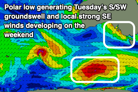
Swell wise, a strong pulse of SW groundswell is due on Tuesday, generated by an intense front come polar low forming south-west of Western Australia Friday, generating a good fetch of severe-gale W/NW-W winds.
This swell looks sizey, coming in 4-5ft across the Surf Coast and 6-8ft to the east, easing Wednesday with those more favourable winds from 3ft on the Surf Coast and 4-5ft+ to the east.
Thursday morning should be clean again with a possible reinforcing pulse of mid-period S/SW swell but we'll have a closer look at this on Friday.


Comments
Lot of sand erosion following the recent SE smashing the SC copped last week (and seaweed...). Torquay surf beach will be interesting for the summer crowds, mostly just exposed rocks now
Willyweather saying 20.7 feels like 19.5. Get fucked.
Surely not the only one feeling like the heat has gone through the roof in the last couple of hours?