Poor weekend, a little better mid-late next week
Victorian Surf Forecast by Craig Brokensha (issued Friday December 1st)
Best Days: Early Wednesday Surf Coast next week, Thursday morning to the east, Friday morning
Features of the Forecast (tl;dr)
- Easing SE windswell on the weekend with fresh and gusty S/SW-S winds tomorrow
- Light-mod S/SE winds Sun AM, freshening into the PM
- Small, background mid-period SW swell for later tomorrow, easing Sun
- Small to tiny Mon and Tue with N/NE-NE tending SE winds Mon, early W/NW tending SW-S/SW and strengthening Tue
- Small-moderate sized, inconsistent W/SW groundswell arriving later Tue, peaking Wed
- Early W/NW tending SW-S/SW winds Wed, strengthening
- Small-moderate sized mid-period W/SW swell Thu with variable tending SE winds
- Easing surf Fri with N/NE winds ahead of a strong S/SW change
Recap
Wednesday’s, large, stormy surf out of the south-east continued yesterday on the Surf Coast but with a little less vigour, and this morning we’ve got a bit less size again along with a touch less wind leaving weaker, smaller surf across all locations.
This weekend and next week (Dec 2 - 8)
The current weakening pattern of wind and windswell is thanks to the inland low that drifted south-east and into the Tasman Sea mid-week, now weakening and starting to push off further to the east. This will see winds tilt a little S/SW into tomorrow (fresh and gusty) as we fall under the backside of the low, though another high starting to edge in on Sunday, swinging winds back to the S/SE though much weaker and only light to moderate.
Unfortunately the blocking effects of high pressure sitting across the Southern Ocean means there’s no decent swell due, with easing levels of windswell tomorrow, and some very inconsistent, mid-period background swell on Sunday.
We’re talking 1-2ft sets max on the Surf Coast, 2ft to possibly 3ft to the east Sunday morning, fading Monday.
Our offshore NE-N/NE breeze is still expected on Monday but the surf will be bottoming out, tiny on the Surf Coast and hardly 1-2ft to the east unfortunately.

Tuesday looks similarly tiny and an approaching front looks to bring a shift in winds to the W/NW in the morning, shifting S/SW and strengthening in the wake of it through the afternoon.
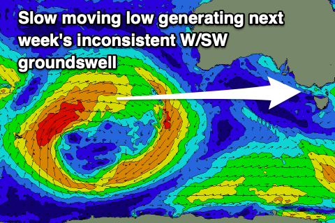
Some small but fun and inconsistent W/SW groundswell mixed in with mid-period swell is due from the earlier stages of this frontal system on Wednesday/Thursday, with it currently taking the form of a broad, low pressure system moving through the southern Indian Ocean.
A fetch of strong to at times gale-force W/SW winds are being generated through our western swell window, with the low due to stall and break down but persist to the south-west of Western Australia this weekend and early next week.
The forerunners of the groundswell are expected to arrive through Tuesday but the size isn’t likely until Wednesday morning, coming in at an inconsistent 2-3ft on the Surf Coast magnets, 4-5ft+ to the east under early W/NW tending SW-S/SW winds mid-morning.
Fun, mid-period energy should maintain similar sized surf on Thursday and winds will start to shift back to the south-east, possibly variable through the morning. Friday looks cleaner with a N/NE offshore with smaller, easing levels of W/SW swell.
Longer term the outlook is wishy-washy and not overly great but we’ll have a closer look at this Monday. Have a great weekend!

