Poor weekend, fun on the beaches early next week
Victorian Surf Forecast by Craig Brokensha (issued Friday 3rd November)
Best Days: Far east locations tomorrow morning for the keen, Monday and Tuesday exposed beaches ahead of sea breezes, Wednesday morning
Features of the Forecast (tl;dr)
- Easing S/SW swell tomorrow with strong but easing S winds to the west, lighter S/SE across PI in the AM, mod-fresh into the PM
- Building SE windswell Sun with strengthening E/SE tending SE winds
- Easing SE windswell Mon with a new, small, inconsistent mid-period SW swell
- Mod-fresh NE winds Mon, tending E/SE-SE mid-late PM
- Easing surf Tue with mod-fresh NE winds, tending SE mid-late PM
- Small-moderate sized mid-period SW swell for Wed PM, easing Thu AM with tricky winds (strengthening N tending NW then S/SW Wed, possibly lighter S/SW-SW Thu)
Recap
Moderate levels of swell have persisted across the state both yesterday and this morning, with yesterday's energy coming off larger surf earlier in the week, while today's swell is a reinforcing pulse generated by active polar frontal activity. Conditions have been generally below average though surfable in some regions in the mornings, choppy through the afternoons.
This weekend and next week (Nov 4 - 10)
The weekend ahead looks fairly poor as a deepening inland surface to our north-east squeezes against a strong high in the Bight, bringing strengthening onshore winds.
Tomorrow morning looks poor with strong S'ly winds, though to the far east, more variable S/SE winds are due, while winds should ease a little to the west into the afternoon creating a slight improvement in conditions.
It won't be pretty though and today's reinforcing S/SW swell will be on the ease, dropping back from 2-3ft tomorrow morning on the Surf Coast and 4ft+ to the east.
Strengthening E/SE winds will kick in Sunday, shifting SE through the day as the trough deepens further and this will produce building levels of SE windswell through the afternoon.

This windswell will ease into Monday as the trough moves east, pushed onwards by the high in the Bight moving in from the west and this will tip winds around to the E/NE-NE, holding until mid-afternoon.
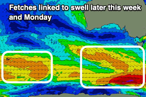
The SE windswell looks to be easing from 2ft+ on the Surf Coast, but some background mid-period SW swell should provide a bit more size and power to both regions. The source of this swell was a weak but broad polar frontal system that developed south-west of Western Australia and this should provide infrequent 2ft+ sets on the Surf Coast magnets, 3-4ft to the east.
With those favourable winds until mid-afternoon it'll be well worth getting a paddle in.
The background energy is due to ease into Tuesday as NE winds persist, holding until mid-afternoon again.

On Wednesday a slightly better pulse of mid-period SW swell is due, generated by another weak frontal system firing up to the south of the country this weekend.
It'll be inconsistent but we should see surf to 2-3ft on the Surf Coast magnets Wednesday afternoon and Thursday morning, 4ft+ to the east but with gusty N tending NW winds ahead of an afternoon S/SW change Wednesday as a trough pushes in. This unfortunately looks to linger into Thursday leaving SW-S/SW winds across both regions, spoiling the small lift in swell.
There's an outside chance for an early W/NW breeze on the Surf Coast but we'll have a closer look at this on Monday. The models also diverge regarding the trough, with GFS having a better wind outcome so we'll have to reassess the local wind forecasts for mid-late next week on Monday.
Longer term the outlook is a little unclear thanks to the model divergence later next week but there are indications that we'll see swell generating systems moving in next weekend providing swell for the middle of the month. Have a great weekend!


Comments
Hi Craig, what are your thoughts on the 9,10,11th still having that easterly component? Looks like a tricky one to predict?
Looks like SW winds unfortunately Thursday with the trough in the region, back to NE Friday morning ahead of a late S/SW change than will then persist Saturday.
The far east does not exist......
What’s up with the Torquay surf cams today?
Rare SE winds have covered the cams in salt. Will get a wash ASAP.