Lingering onshore winds with smaller surf, improving for the beaches next week
Victorian Surf Forecast by Craig Brokensha (issued Wednesday 1st November)
Best Days: This morning Surf Coast, tomorrow morning Surf Coast for the keen, Monday morning to the east, Tuesday morning to the east, Thursday morning to the east
Features of the Forecast (tl;dr)
- Easing surf tomorrow with light-mod S/SW winds (likely light W-W/SW Surf Coast early), freshening into the PM
- Moderate sized reinforcing mid-period SW swell for late tomorrow, peaking Fri AM but with mod-fresh S/SW winds
- Easing surf Sat with strong S/SW winds, easing during the day (possible variable for a period across PI in the AM)
- Strengthening E/SE tending SE winds Sun with a building SE windswell
- SE windswell and mid-period SW swell for Mon with mod-fresh E/NE tending strong SE winds
- Easing swell Tue with fresh NE tending E/SE winds
- Low point in swell Wed with NE tending E/SE winds
- Fun SW swell Thu with NE winds ahead of a S/SW change
Recap
Conditions were lumpy and not perfect yesterday morning with building levels of swell from 3-4ft on the Surf Coast while the beaches to the east were large and messy. A strong onshore change moved in later morning with deteriorating conditions into the afternoon as the larger groundswell moved in.
This swell has eased back into this morning and winds are weaker but lingering onshore to the west, with lumpy surf easing back from 4-5ft on the Surf Coast, 6ft to occasionally 8ft to the east. Make the most of this mornings favourable winds before they shift S/SW and freshen from late morning.
This week and next (Nov 2 - 10)
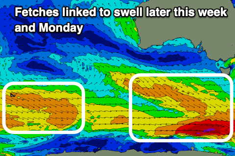
Looking at the outlook for the end of the week, and the current swell energy will continue to ease, but a reinforcing pulse of mid-period swell is due later tomorrow afternoon and Friday morning, produced by a healthy fetch of W/NW winds trailing the strong low linked to yesterday's size.
The Surf Coast should still be 3ft most of tomorrow, 4-5ft to the east but with light to moderate S/SW winds. A local, light W-W/SW breeze is likely again on the Surf Coast creating lumpy though workable waves.

Fresher afternoon sea breezes from the S/SW will spoil the late arriving swell, with Friday morning unfortunately seeing moderate to fresh S/SW breezes lingering. This will be with the peak in mid-period swell to 3ft+ on the Surf Coast and 4-6ft to the east in the morning.
As touched on in Monday's update, a small trough lingering to our east will interact with a strong high to the west (in the Bight), bringing fresh to strong S'ly winds Saturday morning, possibly easing as the trough shifts west, then strong E/SE tending SE on Sunday.
Swell wise small levels of background, mid-period SW energy are due into Saturday afternoon and Sunday, but localised SE windswell looks to become more dominant on Sunday and Monday.
Junky 2-3ft surf is due on the Surf Coast, 3ft+ to the east with the background energy, while Monday looks to be more 3-4ft to the east as winds ease and tend more E/NE. This looks to be a day worth targeting with peaky options to the east with the mix of swells.
The rest of the week looks favourable for the beaches to the east with slowly improving E/NE-NE winds as the high to our west moves slowly under us and swell wise there should be enough background energy to provide fun options. Wednesday looks to be a low point ahead of a small, inconsistent pulse on Thursday. We'll have a closer look at this on Friday.


Comments
Lift ya game Huey !
Party on the surfcoast is over ladies and gentlemen