Steady drop in swell ahead of the next sizey, windy event
Victorian Surf Forecast by Craig Brokensha (issued Monday 23rd October)
Best Days: This morning Surf Coast, Friday mid-late morning to the east for the keen, Saturday morning exposed beaches
Features of the Forecast (tl;dr)
- Steady drop in S/SW swell today, nearly gone tomorrow
- Strong N/NE tending N/NW winds tomorrow AM, W into the PM
- Mod-large W/SW swell for Wed AM, easing
- Gusty W/NW winds Wed AM, strong SW into the PM
- Moderate sized + mix of S/SW swells Thu with strong but easing S/SW-S winds
- Moderate sized mid-period S/SW swell Fri with light SE tending E/NE winds, ahead of fresh S/SE sea breezes
- Small, easing swell Sat with local offshore winds (N/NW to the west, N/NE to the east), tending variable
Recap
Small, clean waves for the keen across the Surf Coast on Saturday and a mix of swells, smaller yesterday morning as the swell came in at a temporary low point before building after lunch as winds held strong from the W.
The lack of SW change and window of clean conditions this morning were thanks to the low stalling a little longer to the west than forecast.
The swell is lumpy and mid-period but large on the Surf Coast to the 5-6ft range on the sets, 6ft+ to the east thanks to the southerly direction but now easing.
Winds are due to shift SW late morning and S/SW into the afternoon though without any major strength (still fresh), weakening into the evening.
This week and weekend (Oct 24 - 29)
With the low linked to today's swell shifting east, the swell generating S/SW winds have been cut off quite abruptly and this will result in a steady drop in swell with nothing of size or power due to be left into tomorrow.
We'll amazingly be looking at leftover 1-2ft sets on the Surf Coast, 2ft to possibly 3ft to the east but mostly 2ft+. Winds will become strong quickly from the N/NE, knocking back the size further, with a shift to the N/NW due late morning and then W due through the afternoon.

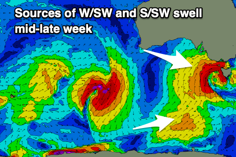
This will be as the next mid-latitude storms moves in from the west, that being a deepening surface trough which will form into a mid-latitude low on approach to us.
We've also got the strengthening polar front that will merge onto the tail of the low as it pushes east across us, but looking at the low first and a fetch of strong to gale-force W'ly winds tomorrow will be followed by similar strength S/SW winds early Wednesday, resulting in a moderate-large W/SW swell for Wednesday morning followed by a S/SW energy later in the day, easing Thursday.
The Surf Coast looks to come at 4-6ft across the magnets Wednesday morning, easing through the day with 8ft surf to the east. Winds will be favourable for the Surf Coast in the morning with a gusty W/NW breeze, shifting SW into the afternoon and with strength, while Thursday looks poor with strong S/SW-S winds, easing gradually through the day.
Now, the polar front will project a fetch of strong S/SW winds up through our southern swell window during Wednesday, producing a moderate sized mid-period S/SW swell for Friday that looks to come in at 4ft or so across the Surf Coast and 5-6ft to the east.
Winds look to improve, with dawn SE breezes due to tend variable and even E/NE to the east before S/SE sea breezes kick in. The size will be tricky for the exposed beaches though with Saturday still looking to be the pick with local offshore N'ly winds but smaller, easing 2ft waves on the Surf Coast, 3ft or so to the east.
Moving into next week and some sizey swell is on the cards for early-mid next week but winds look to possibly be an issue again, being out of the south-western quadrant. More on this Wednesday though.


Comments
Many crew from Vic still hitting the Tulla Tub very often? What’s the crowds like these days?
Water temp?
Here's the incoming system.
https://twitter.com/andrewmiskelly/status/1716649271234023790
Thoughts on if it’s moving too quickly east to produce any swell for the protected areas to the west and is there enough strength in the southerly component. Also when these systems travel east do you think there is much SE radial spread that will make its way up the west side of Tasmania.
For example, how much of the center of this low would Victoria get or are we only getting the lighter winds to the side.
Latest thoughts here Dbut.. https://www.swellnet.com/reports/forecaster-notes/victoria/2023/10/25/pl...