Easing surf with improving winds ahead of a good swell late week
Victorian Surf Forecast by Craig Brokensha (issued Monday 16th October)
Best Days: Tomorrow for the keen from mid-morning, Wednesday exposed beaches, Thursday, Friday morning exposed beaches
Features of the Forecast (tl;dr)
- Easing mix of swells tomorrow with early moderate S/SE winds, tending light during the AM ahead of fresher winds later
- Smaller Wed with N/NE tending variable E/NE winds
- Moderate sized S/SW groundswell for Thu with local offshore N winds ahead of E/SE-SE sea breezes
- Easing surf Fri with local offshore N winds, strengthening from the S/SE into the PM
- Small Sat with strengthening NE winds
- Strong NW tending W/NW winds Sun with a late increase in size
- Peak in moderate sized, localised swell Mon with strong W/SW tending SW winds
Recap
Saturday offered a mix of swells with favourable winds for the Surf Coast in the morning, coming in at 3ft across the magnets before winds strengthened into the afternoon and shifted a little more west as a polar front clipped the state.
Yesterday the swell from the front filled in and peaked with great 4-5ft sets under all day offshore winds across the Surf Coast with a few options in protected spots to the east.
This morning it's all come to an end with a trough/low pushing in, bringing some additional local windswell but with strong onshore winds and no quality surf options.
This week and weekend (Oct 17 - 22)
In the wake of today's trough/low moving east, we'll see high pressure edge in and winds shift to the S/SE through tomorrow with a moderate sized mix of easing swells.
Winds are due to be moderate early, easing to light through the morning offering OK waves for the keen ahead of freshening S/SE sea breezes. The Surf Coast looks to ease back from 3-4ft with 4-6ft sets to the east, smaller into Wednesday morning and backing off from 2ft to the west and 3ft to possibly 4ft to the east.

Conditions will be much better for the beaches Wednesday with a N/NE offshore that only looks to shift variable E/NE across the peninsula, weak sea breezy on Phillip Island. Very late in the day we may see some new long-period SW groundswell arriving, but Thursday is a much better chance for this.
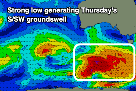
This groundswell which was identified early last week before the system downgraded into the end of the week, now looks quite healthy again. The source is a strengthening polar low developing to the south-southwest of Western Australia today, producing a fetch of gale-force NW winds followed by severe-gale W/NW winds in our southern swell window.
A moderate sized S/SW groundswell is now due, with it peaking Thursday morning to 4ft across the Surf Coast and 6ft+ to the east along with light, local offshore winds. GFS has the storm a little stronger than EC so expect a slight downgrade in the modelled sizes.
Sea breezes look generally weak but out of the E/SE-SE into the afternoon, with Friday morning again looking clean with light, local offshore winds ahead of a trough and more substantial S'ly breeze into the afternoon and evening. The Surf Coast should ease from 2-3ft with 4ft+ sets to the east.
The trough linked to Friday's change looks to deepen into a low while lingering in the region on the weekend, bringing funky winds and some poor, localised windswell mostly likely later Sunday and into Monday.
Saturday shuld see strengthening NE winds and smaller levels of surf ahead of a late SW change and then strengthening NW tending W/NW winds on Sunday, W/SW-SW into Monday. We'll have to have a closer look at this on Wednesday though as the models diverge on the intensity, location and timing of the deepening trough/low.

