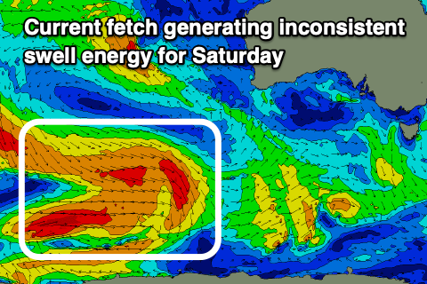
Trickier period of winds and swell
Victorian Surf Forecast by Craig Brokensha (issued Monday 27th August)
Best Days: Exposed beaches today, beaches tomorrow, Saturday on the beaches, Sunday on the beaches
Features of the Forecast (tl;dr)
- Low point in swell early tomorrow ahead of some inconsistent, small-mod sized SW groundswell for the PM, easing slowly Wed
- N/NW winds to the west tomorrow, N/NE to the east, strengthening through the PM
- Gusty SW change early Wed
- Temp low point in swell Thu AM, with some building mid-period W/SW swell into the PM
- Fresh W/NW tending strong SW winds into the PM Thu
- Moderate + sized mid-period W/SW swell Fri with fresh S winds
- Inconsistent W/SW swell Sat, easing Sun
- E/NE-NE tending SE winds Sat, stronger N/NE tending N/NW Sun
Recap
Saturday's peak in SW swell came in bang on expectations with workable winds for the keen on the Surf Coast which saw surf in the 4-5ft range. To the east the swell was too big for the beaches and options were limited.
Yesterday was average to poor with freshening SE winds and a drop in swell.
This morning we've got a further drop in size with light E'ly winds. The exposed beaches to the east are the pick with peaky 4ft sets, smaller, lumpy and 2-3ft to the west. The surf should continue to clean up to the east as winds shift NE ahead of weak afternoon sea breezes.

Lumpy, improving surf today
This week and weekend (Aug 28 – Sep 3)
As touched on last week, the coming period is a bit of breather following the excellent surf seen through the past autumn and most of this winter.
Troughy weather, varying winds and smaller swells will make up the majority of the week, with a temporary low point in energy due tomorrow ahead of some new, inconsistent SW groundswell into the afternoon and Wednesday morning.
The source was a flurry of severe-gale to gale W/NW winds on the polar shelf, to the south-west of Western Australia.
A lift back to an inconsistent 2-3ft is due on the Surf Coast magnets tomorrow afternoon, holding Wednesday morning and then easing.
Winds tomorrow look locally offshore and N/NW to the west, N/NE to the east, strengthening through the day to the east while remaining lighter to the west.

Come Wednesday, a cold front will bring a fresh SW change just after dawn, with a very short-lived period of W/NW winds an outside chance to the west. All in all it looks to be a lay day.
Winds are due to swing back to the W/NW on Thursday with another low point in swell, but into the afternoon, along with a strong SW change, some new mid-period W/SW swell is due to build.
Friday is a much better chance to see this swell, with it starting to be generated by a strong polar frontal system that's currently around the Heard Island region.
The frontal system will weaken while moving slowly east, directing strong W-W/SW winds through our western swell window producing a moderate sized, prolonged mid-period W/SW swell from Friday through Saturday, easing Sunday.
Size wise the Surf Coast should come in 3-5ft on Friday with 6ft+ sets to the east, easing a touch Saturday back to the 3-4ft and 5-6ft range, then easing more noticeably on Sunday.

Unfortunately winds look poor Friday, with fresh S'ly winds due in the wake of Thursday afternoon's front and change, improving Saturday and tending E/NE-NE which will favour the beaches. Sunday as the swell eases looks to see stronger N/NE tending N/NW winds, which will again favour the beaches with easing 2ft waves on the Surf Coast and 3ft to occasionally 4ft to the east.
Looking at next week, and a strong mid-latitude low firing up and into Western Australia later this week and into the weekend looks to generate a strong but fairly westerly aligned W/SW groundswell for early-mid next week. We'll have a closer look at this on Wednesday though.


Comments
Hey just a heads up the forecaster notes link from the Torquay report is broken but if I clicked from Phillip island it works.
Then links to report or forecast return errors or take you to random article list rather than named link. Just an fyi.
The link to the Forecaster Notes generally depends on which report location you looked at last. Not the forecast page, but the report page. That might be the issue?
Yeah this is different I can’t upload a pic here but it goes to a ‘search temporarily unavailable’ error? Seems to not be an exact science which is unusual so thought I’d flag.
Search is temporarily unavailable. If the problem persists, please contact the site administrator.
• The page you requested does not exist. For vour convenience, a search was performed using the query node forecast.
X
Sorry, we could not find that page. Below is a list of pages that might be close.
Enter terms node forecast
Search
• Check if your spelling is correct, or try removing filters.
• Remove quotes around phrases to match each word individually: "blue drop" will match less than blue drop.
• You can require or exclude terms using + and -: big +blue drop will require a match on blue while big blue -drop will exclude results that contain drop.
Then from that error if I want to go back to forecast here is the link it’s going to
https://www.swellnet.com/node