Winds look to spoil the coming swells
Victorian Surf Forecast by Craig Brokensha (issued Friday 11th August)
Best Days: Today keen surfers, Surf Coast tomorrow ahead of the change, keen surfers Sunday through Tuesday, Wednesday
Features of the Forecast (tl;dr)
- Small-moderate sized, inconsistent mid-period W/SW swell arriving later Fri, peaking Sat with fresh NW winds, tending W/NW early PM, then SW mid-late PM
- Moderate sized, mid-period SW swell arriving late Sat, peaking Sun, easing slowly Mon
- Light-mod S tending S/SE winds Sun
- Light-mod S/SE-SE winds Mon
- Light-mod S/SW-S winds Tue
- Small-moderate sized SW groundswell for Tue PM, easing Wed with fresh N/NW winds on the Surf Coast and N/NE to the east
- Inconsistent W/SW groundswell Thu with strong N/NW tending SW winds
Recap
Average surf yesterday with a low point in swell through the morning, full and to 1-2ft max on the Surf Coast but building into the afternoon with a shift in winds to the W/SW.
This morning the swell has cleaned up on the Surf Coast with sets to 2ft+ on the magnets with clean conditions, though it's low in period. This swell will ease through the day ahead of some new mid-period W/SW swell later in the day as winds hold from the NW.
This weekend and next week (Aug 12 - 18)
The coming weekend will consist of building levels of mid-period SW energy, in size, power and consistency but at the peak, winds and conditions look average.

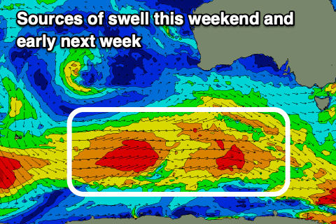
A broad but generally weak polar frontal progression firing up south-southwest of Western Australia mid-week, has generated fetches of strong W/SW winds, with a couple of gale-force bursts, with the progression moving under the country today.
Later today and more so tomorrow the first pulse of weaker energy is due, coming in at 3ft on the Surf Coast magnets, 4-5ft to the east.
The strongest pulse of swell, generated by the burst of gales is due later in the day, peaking Sunday to the 4ft range on the Surf Coast and 6ft to the east (there's the chance for the rare bigger one), easing slowly Monday from 3-4ft and 5-6ft respectively.
Now, winds tomorrow will be favourable for the Surf Coast most of the day, gusty from the NW, shifting W/NW early afternoon ahead of a mid-late afternoon SW change thanks to a trough moving through. This looks to be right when the stronger swell might be showing, with Sunday looking dicey.
Light to moderate S tending S/SE winds are due across most locations during the peak of the swell Sunday, with possible variable winds on the Surf Coast early. Don't count on it and expect bumpy, workable surf all day.
Monday and Tuesday now look dicey as well as the trough lingers across our region, bringing light to moderate S/SE-SE winds on the former. Tuesday looks similar with light to moderate S/SW-S winds spoiling the easing swell energy.
All in all the peak of the swell looks to be spoilt but there'll be surfable waves for those with lower expectations.

Wednesday looks the pick for a clean wave with local offshore winds (N/NW Surf Coast and N/NE to the east), holding most of the day.
Swell wise, an inconsistent groundswell generated in our medium-range swell window, along the polar shelf, east of the Heard Island region, is due to arrive Tuesday afternoon and then ease Wednesday.
A good fetch of pre-frontal NW gales should maintain 2-3ft sets on the Surf Coast Tuesday afternoon, with 4-5ft sets to the east, easing Wednesday from 2ft and 4ft respectively.
A very long-range W/SW groundswell generated by a stronger frontal progression that formed south of South Africa and pushed east along the polar shelf is due to fill in Thursday, though it'll have no major size attached. Inconsistent 2-3ft sets are due on the Surf Coast and with 3-5ft waves to the east along with strong N/NW winds ahead of a front and afternoon SW change.
This front looks to be attached to a mixed frontal progression moving in from the west mid-late next week, bringing moderate sized levels of W/SW swell Friday through next weekend. The models are still a bit divergent regarding this though so check back Monday for an update. Have a great weekend!

