Easing surf over the coming days with favourable winds
Victorian Surf Forecast by Craig Brokensha (issued Monday 7th August)
Best Days: Today, tomorrow morning, Wednesday exposed spots, Sunday morning, Monday
Features of the Forecast (tl;dr)
- Easing SW groundswell today with winds tending light S/SW-S
- Smaller tomorrow with light, local offshore winds and weak S/SE-SE sea breezes
- Inconsistent, small mid-period W/SW swell arriving late tomorrow, peaking Wed AM, then easing
- Strengthening N winds on Wed (N/NE at times to the east and N/NW early Surf Coast)
- Low point in swell Thu AM with strong W/NW tending W/SW winds
- Building small close-range W/SW swell Thu PM, easing Fri with W/NW winds
- Small-moderate sized mid-period W/SW swell building slowly Sat PM with W/NW winds, tending SW later
- Moderate sized mid-period SW swell for Sun and Mon with variable NE tending fresh S/SE-SE winds Sun, NE tending NW on Mon
Recap
Mixed swells and conditions with building surf through Saturday, clean on the faces but a little lumpy to the west, average to the east.
Saturday's close-range increase in swell eased through yesterday with clean 3ft waves across the Surf Coast, bumpier and bigger to the east.
Overnight, a new pulse of SW groundswell arrived with peak periods hitting 20s on the Point Nepean wave buoy, followed by the size early morning. Today we've got strong but easing sets from the 4ft range on the Surf Coast (rare 5ft bomb), 6ft to the east which is bang on forecast. Winds will shift light S/SW-S through this afternoon as the swell slowly drops, creating workable conditions all day.

Inconsistent bombs this AM
This week and weekend (Aug 8 - 13)
The current SW groundswell will ease through this afternoon and drop further tomorrow ahead of a small, inconsistent mid-period W/SW swell arriving later in the day, peaking Wednesday morning and then easing through the day.
Light, local offshore winds are due tomorrow with easing 2-3ft sets on the Surf Coast magnets, 3-5ft to the east ahead of weak S/SE-SE sea breezes.
The inconsistent, small W/SW swell was generated by a strong but distant frontal system pushing up behind the polar low linked to this morning's swell, through the southern Indian Ocean.
Wind strengths failed to really hit the gale-force range and with the distance and west direction, we can expect inconsistent surf to a slow 2ft+ on the Surf Coast magnets Wednesday morning, easing through the day with 4ft+ sets t the east though a long wait for them.
Strengthening N'ly winds will favour the exposed beaches on Wednesday (N/NW early Surf Coast and N/NE at periods to the east), strong W/NW tending W/SW on Thursday as a small, weak front clips us. This will be with small, leftover waves Thursday morning, with a weak increase in small windswell possible following the front later in the day, easing Friday.
Fading 2ft waves are due on the Surf Coast Friday morning, 3-4ft to the east along with persistent W/NW winds.

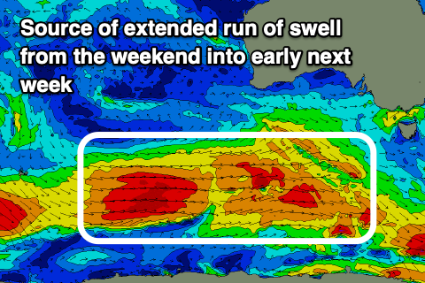
Now, as touched on in Friday's update, we should see the Southern Ocean frontal activity start to fire up again into the end of the week and weekend, with a flurry of healthy polar fronts due to strengthen while pushing east from the Heard Island region, under the country.
This should produce building levels of mid-period W/SW-SW swell through Saturday, peaking Sunday in the moderate size range from the SW, easing very slowly into early next week thanks to the drawn out nature of the progression.
At it's peak we're looking at surf in the 4ft+ range across the Surf Coast, 6ft+ to the east and with favourable winds.
Offshore W/NW winds are due Saturday, shifting SW later with a weak trough, with variable NE winds likely into Sunday, possibly shifting NE to NW on Monday. We'll have a closer look at these winds on Wednesday though when we'll have more confidence.


Comments
Preying those winds stay favourable for the weekend..Sunday now looking a touch dicey
How can you tell if the morning is going to be glassy or more of an offshore northerly flow. Some patterns are obvious but are there some factors that might not be so obvious. For example referring to the peninsula tommorow what would be your prediction of when the wind will pick up more and why. Usually it’s once land warms up a bit but is there some more specifica people would like to share