Fun swells continue for the Surf Coast
Victorian Surf Forecast by Craig Brokensha (issued Friday 28th July)
Best Days: Later today Surf Coast, tomorrow, later Sunday Surf Coast, Monday and Tuesday Surf Coast, Wednesday
Features of the Forecast (tl;dr)
- Moderate sized mid-period SW-S/SW swell arriving later today, peaking tomorrow AM, easing
- Strong N tending NW winds to the east tomorrow, N/NW tending NW to the west
- Small-moderate sized W/SW swell Sun AM, with a late increase in better mid-period W/SW swell
- Strong N/NW tending NW and then W/NW later Sun
- Mod-large W/SW swells building Mon, holding Tue AM and then easing
- Strengthening NW tending later W/NW winds Mon
- W/NW tending variable winds Tue
- N winds Wed with easing surf
Recap
The surf eased back through yesterday across all locations with more options opening up to the east, but becoming windy into the afternoon. The Surf Coast eased slowly from 3ft+ with 4-5ft sets hanging in most of the day to the east, while this morning is much smaller and back to 1-2ft and 3ft respectively.
Into this afternoon a new pulse of mid-period SW-S/SW swell should build back to 2-3ft by dark on the Surf Coast and 4-5ft to the east as winds hold from the NW.

Windy sets yesterday PM
This weekend and next week (Jul 29 – Aug 4)
Later today's fun pulse of mid-period swell is due to peak tomorrow morning, generated by a strong, healthy polar frontal system moving through our swell window earlier this week.
Sets to 3-4ft are due on the Surf Coast magnets tomorrow morning with 5-6ft waves to the east, easing into the afternoon, smaller Sunday morning.

Winds will favour selected regions to the east but be quite strong, N'ly in the morning and N/NW to the west, shifting NW across all locations after lunch.
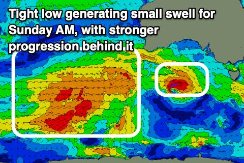
A small pulse of reinforcing mid-period W/SW swell is due through early Sunday generated by a tight low moving through the Bight today, but this only looks to maintain 2-3ft waves on the Surf Coast and 4-5ft sets to the east.
Winds will be strong out of the N/NW favouring the Surf Coast, shifting NW into the afternoon and then W/NW later.
Later in the day we should start to see building levels of mid-period W/SW swell, generated by a strong Southern Ocean frontal progression pushing up and under Western Australia.

Strong W tending W/NW winds moving through from this evening and tomorrow should generate later Sunday's pulse, with an increase to 3ft+ due on the Surf Coast by late, but come Monday, stronger gale-force W-W/SW winds forming directly west-southwest of us should produce a moderate to large sized pulse of mid-period energy through Monday and Tuesday.
Overall size wise for the Surf Coast is looks to be in the moderate + range with Monday building to 4-5ft into the afternoon with 6-8ft sets to the east, easing from a similar size Tuesday morning.
Conditions should be favourable through this period for the Surf Coast with a strengthening NW breeze on Monday, tending W/NW later and then W/NW tending variable winds on Tuesday.
Wednesday looks good for more exposed beaches with the swell due to continue easing with N'ly winds. Longer term a significant Southern Ocean storm is expected to fire up to the south-west of Western Australia, but it's structure and alignment don't look ideal, with the swell focussed more north into the Indian Ocean. We'll have a closer look at this on Monday, have a great weekend!


Comments
What’s your take on this Craigoss
The wind dropped right out at SC but still howling in the city. How does a 30 knot North not make it over the bay. Reckon it’s just SC being shitehouse?
Or can you get pockets where wind drops right out?
Same thing happened at Fawkner Beacon at 3am when winds briefly went SW, then eased to become light and variable.
I haven't been watching the synoptics but could have been a local t'storm cell in both instances.
I guess that’d be it. I just thought it was odd how Melb is still blowing hard yet the wind dropped right out round here then picked up right back up. Storm cell sounds right to me (don’t know how they work though).
What you've done is - as it's known in the industry - cherry pick the data. Winds were generally gusty at SCI through the evening, just a small period where it eased back.
Just saw your second post above!
Picked cherries up Red Hill way for some coin when a grom. Prick of a job, with some seriously strange types for company.
Fun swells have continued, as Craig said they would. Would recommend.
https://www.unimelb.edu.au/newsroom/news/2023/july/ocean-waves-and-the-i...
Don’t know what to think of this research, anyone wanna weigh in on it?
Talk about bizarre winds check the aireys inlet wind obs on bom for the last few hours???