Strong mix of groundswells for the coming days
Victorian Surf Forecast by Craig Brokensha (issued Monday 24th July)
Best Days: Tuesday, Wednesday, Thursday, Saturday, Sunday exposed beaches, early next week
Features of the Forecast (tl;dr)
- Moderate-large W/SW groundswell for tomorrow, peaking through the day
- Large SW groundswell arriving late tomorrow, peaking overnight, easing Wed and further Thu
- Light-moderate W/NW tending variable winds tomorrow, N/NW tending variable Wed
- Fresh to strong N tending N/NE winds Thu
- Strong W/NW winds Fri
- Moderate sized mid-period SW swell for Sat with NW tending variable winds, easing Sun with N/NW tending NW winds
- Mod-large W/SW groundswell for early next week
Recap
Friday afternoon's slow increase in W/SW groundswell and mid-period energy seemed to come in much better Saturday morning with clean conditions and 3-4ft sets on the Surf Coast magnets, bigger and bumpier to the east.
Yesterday was poor as the swell reached a temp low point and a trough brought onshore winds from dawn to the west, with a slight window to the east (more so Phillip Island).
Today we've got slow levels of background mid-period W/SW swell to 2-3ft on the Surf Coast, choppy and to 4-5ft to the east.
This week and weekend (Jul 25 - 30)
All eyes are on the coming days when a strong mix of large W/SW and SW groundswells are due to fill in, with the two possibly destructively interfering at times providing funky double ups more so into tomorrow afternoon if anything.

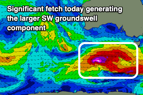
This is the only possible downside to the coming days, with a broad, complex low generating a mixed fetch of pre-frontal, severe-gale W/NW winds, with tighter storm-force W'ly winds around a small low pressure centre on the weekend.
This was east of the Heard Island region (more aligned with our western rather than south-western swell window) and the remnants of the complex low are now re-strengthening south of the country, with an additional fetch of severe-gale to storm-force W'ly winds now moving through our south-western swell window.
What this will result in is a moderate to large, inconsistent W/SW groundswell for tomorrow, with a larger, more consistent SW groundswell due later in the day, peaking overnight and easing Wednesday.

The Surf Coast should be around 4-5ft through tomorrow, with the large swell kicking later to 6ft+, easing from the 5-6ft range Wednesday morning. (8ft sets are very likely on dark and into the evening tomorrow), unlikely Wednesday morning.
To the east 6-8ft sets are due tomorrow morning with larger bombs showing later in the day, easing from the 8ft range on Wednesday morning.
Local winds will be favourable tomorrow morning for the Surf Coast and light to moderate W/NW, tending variable into the afternoon, with Wednesday seeing great, light to moderate N/NW tending variable winds.
Thursday will be smaller with easing 3-4ft sets on the Surf Coast, 5-6ft to the east, smaller and back to 2-3ft and 4ft+ through the afternoon. Options should open up to the east on Thursday with fresh to strong N tending N/NE winds, holding from the N to at times N/NW to the west most of the day.
A temporary low point in swell is due on Friday morning with strengthening W/NW winds as a weakening front/come trough slides in from the west.

A fun sized mid-period SW swell is due on Saturday, generated by a good but fairly short-lived fetch of strong to gale-force W/NW-W winds on the polar shelf tomorrow afternoon through Wednesday morning.
A bump back to 3ft is due on the Surf Coast Saturday, 4-5ft to the east under NW tending variable winds, smaller Sunday with N/NW tending NW winds.
Longer term, as touched on in last week's notes, a significant Southern Ocean frontal progression forming east of the Heard Island region later this week looks to produce a moderate to more likely large W/SW groundswell for early next week but we'll have a closer look at this on Wednesday.


Comments
Impressive numbers from CS.
Hard to fault today really, warm (relatively), zero wind and just pumping waves.
How big was the west coast before dark?
Definitely were double ups in the swell mix as Craig alluded to in Mondays notes..
Only 1 or 2 waves in each set seemed to hit the reef right where I was surfing.
Thanks Kirwoods, heard the same from a reef in South Australia, mucked up a few sets during the day,
Everyone has a different opinion on size but by 3-4pm I’d say 6ft sets at winki. Bigger at bells. Lots of water moving. Not huge but plenty of power.