Slow swells for today and tomorrow, large surf next week
Victorian Surf Forecast by Craig Brokensha (issued Friday 21st July)
Best Days: Today, tomorrow Surf Coast, early Sunday to the east for the keen, Surf Coast Monday morning, Tuesday, Wednesday, Thursday
Features of the Forecast (tl;dr)
- Mix of inconsistent mid-period and W/SW groundswell building today, peaking into the PM, easing slowly tomorrow
- W/NW tending variable winds today, fresh NW but easing tomorrow
- Moderate sized, mid-period W/SW swell building later Sun, peaking Mon
- Fresh S'ly winds kicking in around dawn Sun, light N/NW early to the east
- Lingering SW winds Mon AM to the east, light W/NW to the west
- Large mix of W/SW and SW groundswells filling in Tue, peaking through the day with W/NW-NW tending variable winds
- Slow easing swell Wed with NW tending variable winds, smaller Thu with strong N winds
Recap
Wednesday's swell dropped significantly overnight with windy, leftover 2-3ft waves to the east with workable conditions through the morning, tiny on the Surf Coast.
Today we've got a morning increase in mid-period W/SW swell to a weak 2-3ft on the Surf Coast and a bumpy, raw 4-5ft to the east.
Some stronger but inconsistent W/SW groundswell is due into the afternoon, reaching 4ft on the sets across the Surf Coast magnets (a couple of bigger ones have pushed through aleady but very slow) as winds hold from the W/NW. The only issue will be the big mid-afternoon high tide, swallowing up a lot of breaks.

Slow but sneaky sets starting to show this morning
This weekend and next week (Jul 22 - 28)
Looking at the slow swell today, we're expected to see this afternoon's increase in inconsistent W/SW groundswell along with the mid-period energy easing into tomorrow, though likely not dropping below 3ft on the Surf Coast magnets and 4-5ft to the east.
There should be the rare bigger one at times in the morning, while Sunday morning looks to hold that slower 3ft and 4-5ft range respectively west and east of Melbourne.
Into Sunday afternoon some new mid-period W/SW swell is due, peaking through Monday, generated by a healthy pre-frontal fetch of W/NW winds swinging in from the south-east Indian Ocean.
A little boost to 3ft+ is due on the Surf Coast with 4-5ft+ sets to the east later Sunday and Monday morning but local winds will be an issue.
Tomorrow should be clean all day with a fresh NW'ly, easing through the afternoon while a trough is still due to move in Sunday, with the window of lighter winds due to be shortened.
Dawn on the Surf Coast may see W/NW breezes but S'ly winds are due to be in shortly after, if not by day break, with it arriving mid-morning to the east. Ahead of this N/NW winds will create less than ideal conditions east of Melbourne.
Lingering SW winds are due to the ease on Monday, light W/NW on the Surf Coast, shifting SW into the afternoon and strengthening later.
We then look at the strong W/SW groundswell due into Tuesday.

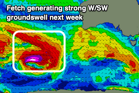
A broad, complex low has formed around the Heard Island region, with a great pre-frontal fetch of severe-gale W/NW winds sitting just above a tight fetch of core, storm-force W'ly winds while tracking slowly east-southeast.
We'll see the fetches and low breaking down while pushing closer to us, south of Western Australia, though the backside of the progression is expected to produce an additional fetch of severe-gale to possibly storm-force W'ly winds south of the country Sunday evening.
What this will result in is a strong, moderate to large W/SW groundswell for Tuesday morning, with a reinforcing SW groundswell pulse for the afternoon.
Size wise, we're looking at the Surf Coast magnets building to a strong 6ft through the day Tuesday with 8ft+ sets to the east and with W/NW-NW tending variable winds.

The easing trend will be slow through Wednesday with easing 5-6ft and 6-8ft sets respectively with NW tending variable winds again.
Stronger N winds look to kick in Thursday as the swell continues to ease, opening up more options but we'll have a closer look at this on Monday.
Longer term we've got some funky mid-latitude activity due late next week ahead of a more significant Southern Ocean frontal progression, but more on this Monday. Have a great weekend!


Comments
Relentless!
What system powers the models on SN?
GFS.
Which is from the NOAA? Just wondering how SN models and the big Willy, which gets it’s data from NOAA, differentiate?
Or is there some trade secrets Craigoracle…
Yep same source, they might run a different resolution or do some after market tweaks (special sauce) like we do.