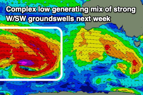
Plenty of swell with slightly trickier winds
Victorian Surf Forecast by Craig Brokensha (issued Wednesday 19th July)
Best Days: Early tomorrow exposed beaches, Friday, Saturday, Sunday early Surf Coast, until the mid-afternoon to the east, Monday morning Surf Coast, Tuesday, Wednesday
Features of the Forecast (tl;dr)
- Small, easing surf tomorrow with strong N/NE tending N/NW winds
- Mix of mid-period W/SW swell Fri AM with stronger W/SW groundswells into the PM, easing slowly Sat
- Moderate W/NW tending lighter W/SW winds Fri, mod-fresh N/NW winds Sat
- Moderate sized reinforcing mid-period W/SW swell for Sun PM and Mon AM
- Strengthening S winds through Sun, though variable early on the Surf Coast and light N/NE to the east until mid-PM
- W/NW tending S/SW winds Mon (SW to the east)
- Moderate + sized mix of W/SW groundswells filling in Tue, peaking into the PM
- Local offshore tending N/NE winds Tue, mod-fresh N-N/NW Wed
Recap
Another great morning of conditions across the Surf Coast yesterday with easing 3ft to occasionally 4ft sets with a bit of north in the wind early, cleaning up quickly ahead of a strong afternoon change.
Some localised mid-period swell was kicked up by this change and winds are improving but conditions are very lumpy and below par across the Surf Coast today and to 4ft, bumpy and 6ft to the east.
We'll see conditions slowly improve across the Surf Coast through the morning as the swell eases, while to the east variable winds are due after lunch but the swell will still likely be quite raw and sizey.
This week and next (Jul 20 - 28)
Looking at tomorrow and it'll be a tricky with a strong N/NE breeze early, shifting N/NW later morning and then holding into the afternoon before possibly weakening a touch.
Swell wise, today's energy will be on the way out with fading 2ft to possibly 3ft sets on the Surf Coast magnets, 3-4ft to the east. With this there should be some options early for the keen to the east.

As touched on in Friday's update, we've got a mix of inconsistent, long-range W/SW groundswell and closer-range, weaker mid-period W/SW swell due Friday, both generated by the same storm.
The groundswell was generated by the initial stages of the storm, that being a strong low in the southern Indian Ocean on Monday. This low generated a fetch of gale to severe-gale W'ly winds in our distant swell window, weakening while pushing east across Western Australia and splitting in two.
This is now seeing a fetch of strong to gale-force W/SW winds to the south of Western Australia, from the southern developments, while the northern split is expected to dip south-east through the Bight today, clipping us tomorrow evening.
What this all will result in is a mix of swells building through Friday and peaking into the afternoon/evening.
The Surf Coast looks to be around 3ft or so in the morning, 4-6ft to the east, building to 4ft and 6ft+ respectively by late in the day.
Saturday should still be 3-4ft on the Surf Coast and 6ft to the east, while some reinforcing mid-period W/SW swell should keep the size up around this size range into Sunday afternoon and Monday morning, easing into the afternoon.
The low point in size at this stage looks to be into Saturday afternoon/early Sunday.
The source of the reinforcing swell will be a healthy frontal system moving in from the southern Indian Ocean over the coming days, producing a fetch of strong to near gale-force, persistent W/NW winds.
Coming back to the local winds and a moderate W/NW breeze is due Friday morning, shifting W/SW into the afternoon as the swell builds, with Saturday seeing great, moderate to fresh N/NW winds.
A trough is expected to bring a strengthening S'ly change on Sunday which will migrate slowly east through the day.
With this early favourable winds may be seen on the Surf Coast, deteriorating through the morning while to the east we should see light N/NE winds deteriorating mid-afternoon.
Monday looks a touch dicey with lingering S/SW-SW winds but the Surf Coast should see a morning W/NW breeze though with a bit of lump from Sunday's winds.

Now, moving into Tuesday we've got our strong, inconsistent W/SW groundswell that was mentioned on Monday due to fill in, peaking later in the day.
The source will be a broad, complex low moving across the Heard Island region tomorrow and Friday.
A great pre-frontal fetch of gale to severe-gale W/NW winds will be closely followed by similar strength W/SW winds, weakening while pushing east towards a line drawn south of Western Australia.
A moderate sized + inconsistent mix of W/SW groundswells are due Tuesday, building to 4-5ft on the Surf Coast and 6-8ft to the east along with what looks to be local offshore winds and afternoon N/NE breezes. The swell will still be solid and slowly easing Wednesday with N-N/NW winds, smaller Thursday with great N/NW breezes.
Longer term there's plenty more on the cards as the good times keep on keeping on.


Comments
best season in years
Isn't it!
Oh joy!
Craig, are those local winds now looking a little more sketchy tomorrow morning?
Apologies Craig, I should have had more faith.
Winds were as predicted