Plenty of swell for the weekend but with average winds
Victorian Surf Forecast by Craig Brokensha (issued Friday 30th June)
Best Days: Today, keen surfers Sunday morning Surf Coast, exposed spots Monday and Tuesday
Features of the Forecast (tl;dr)
- Moderate sized +, mid-period SW swell filling in tomorrow, peaking in the PM with strong SW-S/SW winds (possibly W-W/SW early Surf Coast)
- Easing swell Sun with moderate S/SW winds (likely W/NW early Surf Coast)
- Smaller Mon with variable N tending E/NE winds
- Small-moderate sized SW groundswell arriving late Mon, peaking overnight, easing Tue
- Fresh N/NE tending N winds Tue
- Low point in swell Wed with stronger N winds
- Moderate sized W/SW groundswell likely Thu/Fri
Recap
Wednesday's good kick in swell and sized eased back a touch through yesterday with clean conditions in protected spots and surf mostly to 4ft on the Surf Coast with the rare bigger one in the mix, average and 5-6ft to the east.
Today we've got the next pulse of bigger mid-period swell thanks to a strong frontal system moving through last night and this has boosted wave heights to 4-6ft on the Surf Coast and 6ft+ to the east. Protected spots are the best and should remain clean all day as the swell backs off a touch.
This weekend and next week (Jul 1-7)
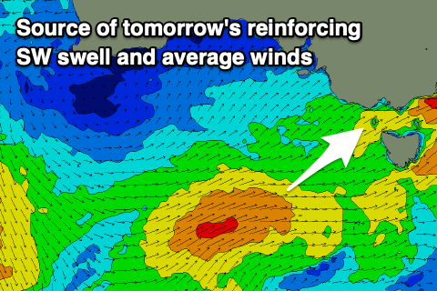
Following last night's front and today's moderate to large spike in mid-period SW swell, we've got one final strong burst of winds swinging in through our swell window that should generate a good pulse of reinforcing SW swell for tomorrow, peaking into the afternoon.

Wind speeds are just below gale-force but with the front moving on top an active sea state, we should see a good kick in size back to 4-5ft through the day on the Surf Coast (likely undersized early).
This swell is then due to ease back steadily from 3-4ft early Sunday morning on the Surf Coast, 4-6ft to the east.
The only issue with the weekend are the local winds, thanks to us falling on the backside of the progression seen through this week. This will see a general SW-S/SW flow, strong tomorrow, weaker but still moderate Sunday.
There's a small chance for early W'ly winds across the Surf Coast tomorrow morning, but they'll likely be more W/SW and conditions fairly raw and lumpy, deteriorating through the morning.
Sunday looks like a better chance for early W/NW winds but lower your expectations.
Come Monday variable N'ly winds are due across most locations, N/NE to the east and tending more E/NE through the afternoon. The swell looks to be smaller, weaker and fading, dropping from 2ft on the Surf Coast and 3ft to possibly 4ft to the east.
Later in the day a new pulse of SW groundswell might be seen, with it due to peak overnight and ease Tuesday.

This funky swell is due to spread out radially from a great fetch of gale to severe-gale NW winds being projected towards the polar shelf this afternoon through early tomorrow, to the south-west of Western Australia.
The swell is likely to hit 2-3ft overnight Monday on the Surf Coast and 4-5ft to the east, though easing Tuesday and just under this size.
Fresh N/NE tending N winds will favour exposed breaks as the swell eases on Tuesday, bottoming out Wednesday with strong N winds.
The longer term outlook consists of W/SW swell energy, building later in the week thanks to a strong mid-latitude frontal progression firing up towards Western Australia, then dipping south-east while weakening and passing under the country.
At this stage we may see moderate sized + levels of swell but we'll have to look at this in closer detail Monday. Have a great weekend!


Comments
50 year storm next wkend??
Fair bit of west in it which might shave some size off
Size has halved on the MP forecast in latest run