Poor surf in general
Victorian Surf Forecast by Craig Brokensha (issued Wednesday 14th November)
Best Days: Saturday morning, Tuesday morning next week exposed beaches, Wednesday next week exposed beaches
Features of the Forecast (tl;dr)
- Moderate sized, mid-period S/SW swell Wed and Thu with strong S winds tomorrow
- Easing surf Fri with moderate S/SE winds, freshening through the day
- Moderate sized SW groundswell for later Fri, peaking Sat AM with light-mod S/SE winds on the Surf Coast, E/NE-NE to the east ahead of fresh sea breezes
- Easing swell Sun with mod-fresh SE winds, strengthening
- Poor mix of swells Mon with strong E/SE tending SE winds
- Small mid-period S/SW swell for Tue PM, easing Wed
- E/NE winds developing Tue AM ahead of sea breezes, NE Wed AM
Recap
Monday's blow kicked up a mid-period swell that packed a little more energy than expected into yesterday morning. It was a bit better than windswell and came in at 3ft on the Surf Coast with offshore winds. A strong change created poor conditions into the afternoon, while today it's a write-off with strong S/SW winds and a moderate sized mix of swells.
This week and next (Dec 15 - 23)
Now that the onshore winds have kicked in proper, we're set to see poor conditions play out over the coming days, with a slight reprieve expected on Saturday before deteriorating again into Sunday.
This run of cold weather and S'ly winds will be linked to a surface trough that moved through yesterday, strengthening into a low in the southern Tasman Sea and stalling to our east through the weekend. The low will be strongest over the coming days, squeezing a strong high sitting under the country, bringing strong S'ly winds tomorrow, a touch weaker and moderate out of the S/SE Friday morning, freshening through the day.
The low will weaken and push a little east on the weekend, allowing winds to ease further and shift E/NE-NE east of Melbourne Saturday morning. The Surf Coast will likely see lingering S/SE winds, creating bumpy through workable conditions.

Looking at the swell due across the state over the coming days, and today's mix of mid-period S/SW swell energy will ease through tomorrow, though some background energy from the Southern Ocean, generated by a polar low should maintain 3ft+ sets on the Surf Coast and 4-5ft sets to the east, easing Friday.
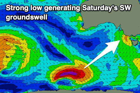
Later in the day Friday we should see a new SW groundswell, with it due to peak Saturday when winds improve. This is being generated by a strong polar low that's formed to the south-southwest of Western Australia, with a fetch of gale to severe-gale W'ly winds being produced.
The groundswell should peak Saturday morning to a 3-4ft on the Surf Coast magnets and 5-6ft to the east, easing into the afternoon and then smaller Sunday. Conditions will be best through the morning ahead of sea breezes, poor Sunday with strengthening SE winds.

Moving into next week, we'll see winds slowly swinging more easterly as an inland low deepens across Western Australia, pushing the strong blocking high slowly to the east and under us.
Swell wise, there's nothing major due thanks to the blocking influence of the high, but we may see a small mid-period S/SW swell for Tuesday afternoon/Wednesday.
The Surf Coast will see a SE windswell be more dominant, with strong E/SE tending SE winds on Monday, shifting lighter E/NE into Tuesday morning and NE Wednesday. We'll have a closer look at this on Friday though.


Comments
Winds are swinging cross-shore and are trying to clean things up.