Fun options for the beaches
Victorian Surf Forecast by Craig Brokensha (issued Monday 17th October)
Best Days: Today until mid-afternoon, tomorrow on the beaches, similar Wednesday morning for the keen, Friday on the beaches, Saturday morning
Features of the Forecast (tl;dr)
- Easing surf over the coming days with E/NE-N/NE tending SE winds mid-late PM tomorrow
- N/NE tending S/SE midday Wed
- Small new SW swell Thu with fresh S/SE winds, strengthening later
- Better SW swell for Fri AM, easing with variable E/NE-NE winds ahead of S/SE sea breezes
- Easing surf Sat with N/NW tending S/SW winds
- New inconsistent W/SW swell for later Sun, peaking Mon with winds unsure. Possibly stronger S/SE
Recap
Poor surf on Saturday with a tiny, weak swell and clean conditions on the Surf Coast, onshore into the afternoon with a little more size. Yesterday was better with a mid-period SW swell and clean conditions on the Surf Coast again, less than ideal to the east.
Today our mix of new S/SW groundswell and stronger SW groundswell have filled in with 3-4ft sets on the Surf Coast and 5ft sets to the east under more favourable winds. Conditions should remain favourable across both regions until early afternoon when a weak S'ly breeze starts to develop.
This week and weekend (Oct 18 - 23)
With today's swell and local winds generally favouring the Surf Coast breaks, we'll see easing size and winds out of the north-eastern quadrant favouring the beaches over the coming two days.
The Surf Coast should still offer 3-4ft sets tomorrow morning, with 4ft+ waves to the east, easing with a variable wind on the Surf Coast and E/NE-N/NE winds to the east ahead of SE sea breezes mid-late afternoon.
Wednesday will be smaller with easing 1-2ft sets on the Surf Coast, 2-3ft max to the east along with N/NE offshore breezes ahead of a weak but strengthening S/SE change around midday thanks to a trough shifting in from the west.
 This trough will linger through Thursday keeping S/SE winds blowing throughout the day, fresh in the morning and stronger later in the day. Swell wise a small new pulse of mid-period SW swell is due, generated by a small low firing up late in our swell window, to our south-west this evening and tomorrow morning.
A fresh pulse of size back to 2-3ft is expected on the Surf Coast, 4-5ft to the east but with those poor winds.
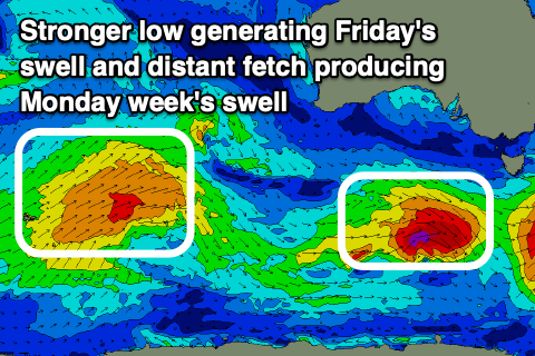
A secondary, slightly stronger and broader low will generate an additional pulse of SW groundswell on Friday with a bit more size and energy due across the state.
A fetch of pre-frontal W/NW gales will be followed by very tight and slim fetch of severe-gale W/SW winds.
 We should see stronger 3-4ft sets on the Surf Coast and 5-6ft waves to the east along with improving winds, shifting E/NE and then NE through the morning ahead of mid-late afternoon sea breezes. Hunt the beaches on the Surf Coast, while the exposed beaches will be chunky, maybe worth a look early afternoon as the size starts to ease.
The swell will ease into the weekend and winds look to shift N/NW, favouring the Surf Coast in the morning ahead of a trough and S/SW change late morning.
The models diverge at this stage regarding the movement and deepening of the trough into Sunday/Monday, with it possibly strengthening leading to poor S/SE-SE winds. This would spoil a moderate sized, inconsistent swell for later Sunday and Monday but we'll have a closer look at this Wednesday.


Comments
A big ring of odd/dirty looking water at Portsea. Water from the bay going out with the heads with the low tide?
It could be washing from Barwon Heads? Mouth of Barwon River to Pt Lonsdale is looking like a chocolate milkshake
Yeah check the OG cam..
Doesn’t smell great either, will be giving OG a wide berth for a while.
Just looking at the low linked to today's SW groundswell, it was a bit stronger than forecast on Friday and more prolonged and it looks to peak this afternoon to 4-5ft+ across the Surf Coast and 6ft+ to the east.
Tomorrow will likely see easing 3-4ft sets on the Surf Coast, 4-5ft to the east.
This morning was heaps of fun, 3 hour dawny to start the week will take that any time!
Hell yeah!