Limited windows of swell and offshore winds to the east
Victorian Surf Forecast by Craig Brokensha (issued Monday 3rd October)
Best Days: Today exposed beaches ahead of sea beezes, selected breaks to the east Wednesday, Thursday morning exposed beaches
Features of the Forecast (tl;dr)
- Easing SW swell tomorrow with moderate to fresh SE winds
- Moderate sized, mid-period SW swell for late tomorrow, peaking Wed AM with strong E/SE-E winds
- Moderate sized SE windswell Wed, easing Thu
- Fading SW swell Thu with fresh E/NE tending NE, then N/NE winds into the PM
- Tiny to flat Fri with N/NW winds
- Incosnstent mix of W/SW swells building Sat, peaking into the PM and Sun
- Gusty W/NW tending strong S/SW winds Sat, S/SE Sun
Recap
A drop in swell across all locations on Saturday with peaky options to to the east for the keen, poor on the Surf Coast.
Yesterday was much better with a new pulse of SW groundswell to 4-5ft on the exposed beaches to the east but with a slightly funky NW breeze. The Surf Coast was clean and to 3ft on the exposed beaches and reefs.
Today there's still 2-3ft of swell across the Surf Coast and 3-5ft to the east with excellent conditions on the beaches. Conditions should remain favourable on the exposed beaches to the east until mid-afternoon as the swell starts easing so get a surf or two in before then.

Great conditions and a good size this AM
This week and weekend (Oct 4 - 9)
Our current SW groundswell energy was generated by an elongated fetch of severe-gale NW winds tracking south-east towards the polar shelf last week. We'll see it easing in size this afternoon with those sea breezes kicking in early afternoon on the Surf Coast, delayed and more mid-afternoon onwards to the east.
Tomorrow will be smaller and a surface trough attached to a broader polar low will move in bringing moderate SE winds for dawn, freshening through the day a little, creating poor conditions.
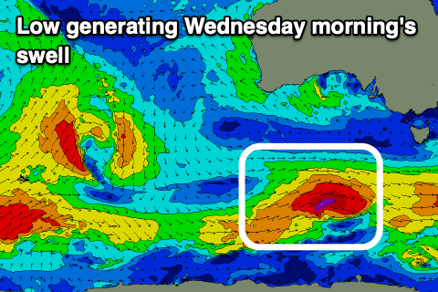
The low will strengthen in the Bight and drift slowly south-east through the middle of the week, squeezing a high to our south-east which will setup up strong E-E/SE winds on Wednesday and a stormy, solid SE windswell for the Surf Coast.
 We're looking at 4-5ft chunky sets on the Surf Coast, while to the east a new mid-period SW swell is due in the 4-5ft range in the morning. This is being generated by a healthy polar front that's currently south-west of us, generating a tight fetch of W/SW gales, with the expected size being upgraded from Friday.
Those strong winds will create tricky conditions though, with Thursday morning looking to be the pick as the low pushes east, swinging winds from a fresh E/NE'ly at dawn to the NE through the mid-late morning. Winds look to go more N/NE into the afternoon and evening, maintaining favourable conditions and size wise. Easing 2-3ft sets are due on the exposed beaches to the east in the morning, small into the afternoon, with fading SE windswell from 2-3ft on the Surf Coast.
Now, the blocking effects of the broad, slow moving low will be seen into Thursday afternoon and Friday as the swell bottoms out.
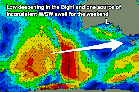
The low won't have any swell generating fetch behind it, with it weakening while moving across us and this leaves us to rely on some very inconsistent, long-range and small W/SW swell energy.
 This is being generated today and tomorrow by a distant fetch of strong to sub-gale-force W/SW winds to the south-west of Western Australia, while some additional small looks to be generated by a very slim fetch of W/SW-SW gales, to our south-west on Thursday.
We should see both swells building Saturday and reaching an inconsistent 2-3ft on the Surf Coast and 4-5ft to the east, holding a similar size Sunday. Winds are unfortunately an issue and only offshore from the W/NW on Saturday morning ahead of any size, with a trough due to bring strong S/SW winds later morning Saturday, with gusty S/SE winds on Sunday.
Longer term there's nothing too obvious swell wise with funky winds and mid-latitude lows/troughs due to persist. Therefore make the most of today.


Comments
If today is ‘7/10’ then my grandpa is King Charles, wouldn’t be more than 10 people in the water along the MP today. Rippa day though
MP banks are putrid rn
Should do the ring round and get a collective report for bank status to add the other variables of the report. There was great conditions today.
The bank-less coast
Beautiful coastline. But remains great on its Day. But it's the Hoax Coast.
I thought Saturday on the SC at 2/10 was overs. This morning at 4/10 was unders. Beautiful morning of waves. Glad the school holidays are over.
Yeah fun surf on SC this am :)
30km of coast and not one decent bank?
Not from what I’ve seen, banks for a swell this size are pretty rare. Frustrating coastline but I wouldn’t want it any other way
you sound surprised Craigos
Haha.
That's right Craig. Absolutely nothing to see down here.
PI - was nice
Agree - great morning on the island!
The MP has banks, and reefs. Just they all can't hold waves over 5ft, due to the ruler edge sandbar which sits 100m out and stretches the whole coast, causing those close outs we all see.
Oh, and when its above 3ft expect arm burning/session ruining rips to appear.
Create something like a large, underwater snow groomer to groom banks on coasts like these on low swell days.
Or fuck the marram grass off and Parks Victoria's dune restorations that are now heavily vegetated but should be sand dunes.
With you on that one!
Been seeing it everywhere here in WA
Parks lol. Can’t fix a single pothole let alone a public toilet block let alone a dune system. They just wanna catch you not parked in between the lines properly with a dog in the car.
Watch out for the undercover rangers bone. They have a flip wallet and I.D. F.B.I style.
I'm getting sick of the post and wire fences, fencing off marram grass infestations, and the signs saying keep out revegetation area.
Ha.
Bang on man!!