Poor surf, improving from Sunday
Victorian Surf Forecast by Craig Brokensha (issued Wednesday 28th September)
Best Days: Sunday morning exposed beaches, Monday, Tuesday and Wednesday mornings on the beaches
Features of the Forecast (tl;dr)
- Slightly smaller surf tomorrow with moderate S/SE winds, easing through the late AM to early PM, then stronger S/SE later
- Mix of mid-period SW swell and SE windswell Fri with strong E/SE winds
- Easing mix of swells Sat with fresh E/SE-E winds tending SE
- New SW groundswell arriving Sat PM, peaking Sun with E/NE tending fresh SE winds
- Easing surf Mon with E/NE-NE tending SE winds
- Fun, small reinforcing SW swell Tue/Wed with NE tending SE winds both days
Recap
It was slow but our inconsistent W/SW groundswell built into Monday afternoon and evening, offering infrequent 3-4ft sets on the Surf Coast magnets with glassy conditions, solid and too big for the beaches to the east and 5-6ft.
Yesterday morning was similar with variable winds and infrequent 3-4ft sets on the Surf Coast magnets, 4-6ft to the east but a strengthening S/SE breeze deteriorated conditions into the afternoon.
This morning, fresh to strong S/SE winds are persisting, creating poor conditions across all locations along with moderate levels of W/SW swell energy.
This week and next (Sep 29 – Oct 7)
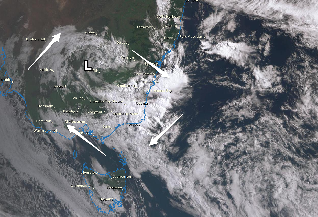
Looking at the current satellite imagery for the country, you can see the broad inland low that's bringing our poor S/SE winds, with it due to strengthen while moving offshore on the NSW South Coast during tomorrow.

Broad, inland low centred around Griffith
The low will dominate our local winds until Sunday, with it broadening while moving slowly east through the Tasman Sea as a high pressure system slides slowly eastward, under us.
The interaction between the low and the high will see poor, persistent winds from the south-eastern quadrant, swinging more easterly through the weekend.
Looking at tomorrow and winds should ease and be moderate in strength from the south, easing across the Phillip Island region later morning and on the Mornington Peninsula early afternoon as a small embedded trough moves west. This will be followed by strengthening S/SE winds later but there might be a window of lumpy waves for the desperate on the beaches.
Swell wise, background levels of W/SW-SW swell are due tomorrow with 2-3ft sets on the Surf Coast and waves either side of 4ft to the east, ahead of a new mid-period SW swell on Friday.
Friday's swell was generated at the start of the week by a low that fired up to the south-west of Western Australia but any surf will be ruined by strong E/SE winds as well as a building SE windswell.
The Surf Coast looks to come in around a stormy 3ft+ with 4-5ft sets to the east, easing Saturday from 2-3ft and 3-4ft respectively. Winds will remain an issue on Saturday and be fresh from the E/SE-E, though selected breaks to the east should offer a surfable wave for the keen.
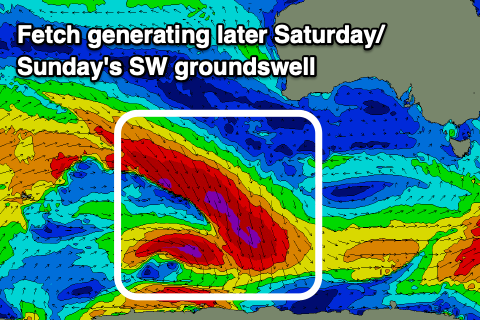
 We should finally see conditions start to improve Sunday as the high moves further east, swinging winds to the E/NE during the morning ahead of fresh SE sea breezes. Swell wise, we've still got our good new SW groundswell, generated by a funky but significant fetch of severe-gale NW winds projecting south-east towards the polar shelf. The fetch will be quite elongated with multiple phases, helping to produce a moderate sized groundswell event, arriving Saturday afternoon but peaking through Sunday.
Good sets to 3ft are due on the Surf Coast with 4-5ft+ sets to the east with that favourable morning for the beaches.
Easing surf is expected on Monday with favourable winds for the beaches again, light out of the E/NE-NE ahead of SE sea breezes.
Looking at the rest of the week and background levels of mid-period SW swell energy is due from persistent but weak polar frontal activity through the weekend and early next week.
Winds look to remain favourable for the beaches Tuesday and Wednesday ahead of a mid-latitude low and shift in winds to the W/NW on Thursday but we'll have a closer look at this Friday.


Comments
summers started early this year, FUCK
You can say that again tubbabird
summers started early this year, FUCK
well played, hehe
To be fair it's actually been reasonably good of late. Monday and Tuesday morning were sublime.
Springtime in Vicco is not exactly dry season Indo.
Typically even worse up north but who knows with Nina she seems a bit loose.
September has been fairly good on the SC actually. A few good reef/point days and some good beaches sessions. The East Coast and PI looked great numerous times. The shit seems to have hit the fan now though, with La Nina fanned South Easterlies. Tubba summed it up well.
September has been better than what all of winter combined was on the SC. Many surfable days with fun swells and good winds.
6.20pm currently 13.1 deg wind chill of 10deg. summer??? yea na mate not yet. far from it.
Can't please some people.
SUMMER STARTS AT EXACTLY 12:00am DECEMBER 1st.
Bit of weather around mid next week.
The Four Seasons. Bout time they updated them. Haven't had a summer in years down South.