Make the most of today
Victorian Surf Forecast by Craig Brokensha (issued Monday 26th September)
Best Days: Today, early tomorrow, selected beaches Sunday morning and next Monday morning
Features of the Forecast (tl;dr)
- Inconsistent, moderate sized W/SW groundswell building Mon PM, holding Tue with N/NE-NE winds this afternoon, variable tending mod-fresh E/SE-SE from mid-late morning tomorrow
- Easing surf Wed with strong S winds
- Slightly smaller Thu with strong S winds, easing and tending E/SE-SE into the PM, strengthening again late
- Mix of mid-period SW swell and SE windswell Fri with strong E/SE winds
- Easing mix of swells Sat with gusty E/SE-E tending SE winds
- New SW groundswell Sun AM with E/SE-E tending SE winds
- Easing surf Mon with N/NE tending SE winds
Recap
Terrible surf on Saturday with a mix of localised windswell and hard to distinguish, inconsistent W/SW groundswell. Conditions cleaned up into yesterday as the trough linked to the change cleared east, bringing improving conditions on the beaches as the day progressed.
Easing sets from 2-3ft were seen on the Surf Coast magnets with 4-5ft sets to the east.
This morning we've got a low point in swell and clean conditions across all spots, but our new W/SW groundswell that's due to arrive into this afternoon has just been picked up by the Cape Sorell wave buoy and we should see sets reaching an inconsistent 3-4ft on the Surf Coast by late with 6ft sets to the east as winds hold from the N/NE-NE.
This week and weekend (Sep 27 – Oct 2)
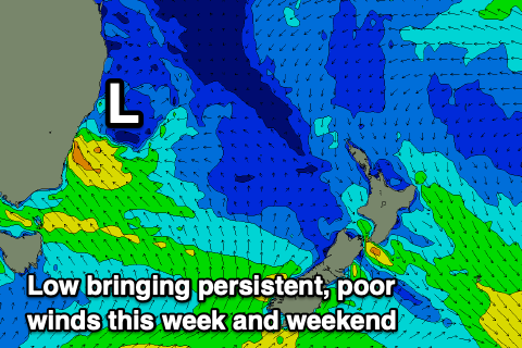
The coming week revolves mostly around the local winds, which are due to deteriorate mid-late tomorrow morning and remain poor until late in the weekend.
 The reason for the deteriorating winds will be a broad, deepening inland low moving east tomorrow with variable winds at dawn due to freshen from E/SE mid-late morning, stronger S/SE into the afternoon.
As the low moves further east and stalls off the East Coast we'll see persistent onshore winds, strong from the S'th on Wednesday and then S tending SE on Thursday, possibly becoming variable while tending more east in direction.
The low is expected to strengthen further into the end of the week, bringing strong E/SE winds and poor conditions while kicking up some localised SE windswell, persisting into Saturday as winds shift a touch more E'ly through the morning
Swell wise, this afternoon's increase in inconsistent W/SW groundswell is due to hold into tomorrow morning with similar 3-4ft waves on the Surf Coast magnets and 6ft sets to the east, easing further Wednesday as those poor winds set in. Smaller levels of background swell are due Thursday ahead of a small-moderate sized mid-period SW swell Friday. This is being generated by a relatively weak polar low to the south-west of Western Australia but the localised SE windswell looks to be more dominant with 3-4ft sets on the Surf Coast and 4-5ft waves to the east.
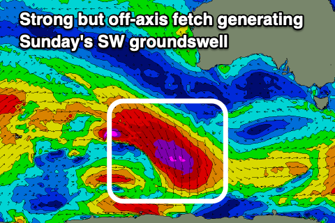
 Moving into the weekend, the windswell will slowly back off in size along with the mid-period swell energy on Saturday, but we should see a good new SW groundswell arriving later in the day, peaking Sunday.
This will be produced by a strong but slightly poorly aligned fetch of gale to severe-gale NW winds projecting south-east towards the polar shelf mid-late week. Due to the great circle paths and radial spread we should see some fun waves showing across the region with Sunday morning seeing 3ft sets on the Surf Coast, 4-5ft on the Mornington Peninsula.
Winds are still a little dicey for Sunday and may be lingering out of the east, swinging more north-east on Monday. This revolved around the movement of the low in the Tasman Sea so we'll have to have a closer look at this Wednesday.


Comments
It's inconsistent but there are some great 3-4ft sets on the Surf Coast cams this morning.