Lots of swell inbound with some great days to work around
Victorian Surf Forecast by Craig Brokensha (issued Monday 22nd August)
Best Days: Early tomorrow for the keen (low expectations), Wednesday protected spots, Friday, Saturday, Sunday
Features of the Forecast (tl;dr)
- Moderate sized mix of mid-period and SW groundswell tomorrow with strong SW winds (W/NW early Surf Coast)
- Moderate sized + SW swell Wed with strong W/NW winds
- Slight drop in size Thu but steadying with a reinforcing mid-period SW swell, holding Fri
- Fresh SW winds Thu, variable Fri (tending S PM)
- N/NE tending SE winds Sat with a slightly smaller, reinforcing SW swell
- Easing swell Sun with stronger N/NE-N winds
- Inconsistent, moderate sized W/SW groundswell building Mon, peaking later/overnight, easing Tue
- N/NW tending S/SW winds Mon, possibly lingering S Tue
Recap
Poor surf on Saturday with an onshore change and an average mix of swells, cleaner and better yesterday along with an inconsistent mid-period W/SW swell to 2-3ft on the Surf Coast, bigger to the east but bumpy.
The swell eased through the day and this morning we've reached a low point in between swells with strong offshore winds ahead of an afternoon SW change.
This week and weekend (Aug 23 - 28)
From tomorrow onwards we've got plenty of swell inbound, with this afternoon's change linked to the first of a progression of cold fronts pushing up towards us through the Southern Ocean.
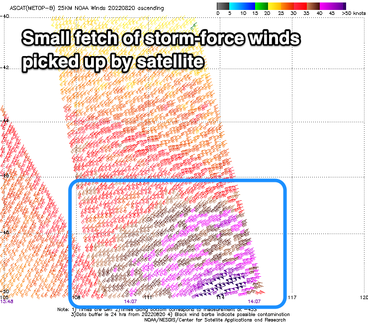
A good pulse of SW groundswell is due to peak tomorrow, generated by an initial polar low that was moving through our swell window last week, though strongest through Friday before weakening on the weekend as moving east and expanding.
 The core winds speeds in this fetch were actually fairly impressive and reached storm-force at its core, a little stronger than the models were forecasting.
This will result in a mix of mid-period and groundswell energy tomorrow, peaking through the day with surf to 4ft across most Surf Coast locations, with the odd bigger bomb likely on the magnets (afternoon) owing to that storm-force fetch. The peninsula looks to be in the 6ft range mostly with the rare bigger one.
Unfortunately conditions won't be the best as a cold front pushes up and into us, bringing strong SW winds that will likely be W/NW early for a period in the morning on the Surf Coast. Expect raw conditions and surf that will likely be a little undersized at dawn.
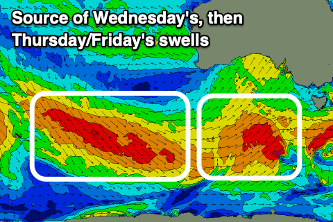
Wednesday still looks the pick with strong, persistent W/NW winds and a mix of new mid-period SW swell. This will be generated by a polar fetch of strong to gale-force SW winds projecting north-east today, easing tomorrow once pushing across us, bringing those poor conditions.
 Size wise the Surf Coast should be a good 4-5ft with 6ft to possibly 8ft sets to the east and those favourable winds for protected locations.
The swell should drop a touch into Thursday but a reinforcing mid-period SW swell generated by a great fetch of strong to gale-force W/NW tending W winds swinging in under the country will steady wave heights through the day, holding Friday.
Good, fun 4ft surf should persist on the Surf Coast magnets both Thursday and Friday with 6ft sets to the east. Winds will unfortunately swing back to the SW on Thursday as a front clips us, though only fresh in nature. The likelihood of early W'ly winds look low but we'll review this Wednesday.
Friday will become cleaner across both regions with a variable breeze due (light W/NW on the Surf Coast and slack to the east). This will favour the Surf Coast with lumpy options east of Melbourne.
As touched on in Friday's update, winds will be great into the weekend but our reinforcing pulse of S/SW swells look to be smaller and not as pronounced. This will favour the beaches though and not be too overpowering.
 We're probably looking at 3ft surf on the Surf Coast Saturday with 4-5ft sets to the east under N/NE tending light SE winds, smaller and easing Sunday with fresh N/NE-N breezes.
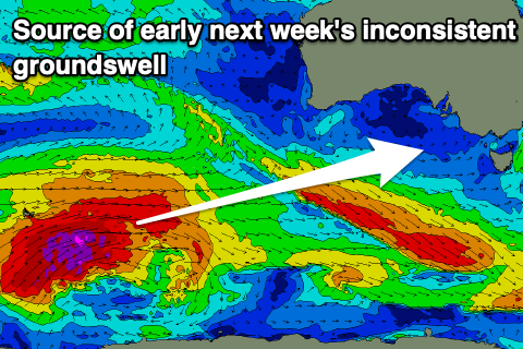
Looking longer term and a long-period, inconsistent W/SW groundswell is due into the start of next week, generated by a very strong low developing south of the Heard Island region mid-late week. Size wise it looks moderate, with it building Monday and peaking later in the day/overnight.
The Surf Coast should reach 4ft at the peak with 6ft sets to the east though a trough looks to bring an onshore afternoon change Monday, possibly lingering Tuesday. More on this in Wednesday's update.


Comments
Something for everyone
Recon on the Mp you might be able to tackle Harry Potter and the piglet's papilloma that's about it.
Schools fucked. Though maybe around 2/5ths of the square root of 9