Increasing activity from late week
Victorian Surf Forecast by Craig Brokensha (issued Wednesday 17th August)
Best Days: Exposed beaches today, Surf Coast Friday afternoon, Sunday Surf Coast, Wednesday and Thursday Surf Coast
Features of the Forecast (tl;dr)
- Low point in swell tomorrow with strengthening N tending N/NW and then NW winds
- Building mid-period W/SW-SW swell Fri PM (small in AM) with fresh W/NW winds
- Easing SW swell Sat with strong but abating SW-S/SW winds
- Inconsistent mid-period W/SW swell Sun with NW winds
- Small Mon with strengthenging N/NW winds
- Moderate sized SW groundswell Tue with strong SW winds, easing through the day
- Mix of moderate sized + swells Wed with fresh NW tending W/NW winds
- Easing surf Thu with NW winds, tending SW later
Recap
Terrible surf and developing stormy conditions across both coasts yesterday as the broad low that's dominated our local weather and surf since the weekend started to move off to the east.
Today we've seen winds quickly abate and swing back to the N'th but with a weak, easing windswell from 2ft on the sets on the Surf Coast and a lumpy 3ft to the east. Conditions will become cleaner into the afternoon on the exposed beaches as winds hold from the N-N/NE and strengthen. The swell will fade though but there should be a window of cleaner conditions and fun sized sets.

Improving conditions on the beaches today
This week and weekend (Aug 18 - 21)
Tomorrow will be a lay day as the current windswell eases in size today, bottoming out tomorrow under a strengthening N'ly tending N/NW and the NW breeze.
This shift in winds will be associated with an approaching frontal system and low, with Friday now looking more favourable as it tracks south-east, leaving W/NW winds that should persist all day.
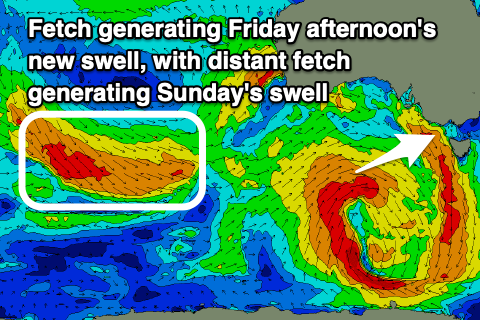
 During today we'll see the low generating a healthy fetch of strong to gale-force W-W/SW winds through our western and south-western swell windows, generating a mid-period swell for Friday afternoon. Don't expect much in the way of size in the morning with slow 2ft sets possible on the Surf Coast with 3-4ft waves to the east. The new swell should build into the mid-late afternoon, reaching 3ft on the Surf Coast and 4-5ft to the east, possibly a smidge bigger on the sets near dark. With those W/NW winds, protected spots will be best.
A drop in swell is expected Saturday morning from 2-3ft on the Surf Coast and 4-5ft to the east, but winds will be poor as we fall under the backside of another front/trough moving in from the west. This will bring strong SW-S/SW winds that will abate through the day and poor conditions.
The next approaching frontal progression will swing winds back to the NW on Sunday and a reinforcing pulse of mid-period W/SW swell is due, generated by a fetch of distant, strong to gale-force W/NW winds swinging in from the Indian Ocean tomorrow, then through the Bight while weakening Friday.
This swell will be inconsistent and only looks to come in around 2-3ft across the Surf Coast on Sunday with 4-5ft sets to the east.
We'll see a temporary low point in swell Monday morning under strengthening N/NW winds ahead of an evening SW change, linked to a strong but weakening Southern Ocean frontal progression moving in from the south-west.
 This progression will actually develop south of South Africa today, moving east while slowly strengthening and consolidating. This initial polar low looks strongest south-west of Western Australia on on Friday afternoon and evening, with a fetch of broad W/SW gales expected, with the low due to expand but weaken while projecting towards us through Sunday and Monday.
This will produce a moderate sized SW groundswell for Tuesday coming in around 3-5ft on the Surf Coast and 6ft+ to east but with gusty, lingering SW winds in the wake of Monday evening's change.
Some additional mid-period SW swell will be generated by this change, with Wednesday looking better under fresh NW tending W/NW winds and surf to 4-5ft on the Surf Coast, 6ft to occasionally 8ft to the east.
There's still a bit of room for movement regarding each swell pulse and the local winds so check back here on Friday and Monday for a bit more confidence.
It looks like we'll see plenty of follow up frontal activity through early-mid next week generating some reinforcing pulses of SW swell through the end of the week along with W/NW tending SW winds. More on this Friday.


Comments
Peak period at 2.9sec, buoy break off with this wind and it bobbing around in the bay or something?
have to have a pretty small board to fit into that period
4 am period 2.7sec @ 312 degrees
Ha, mental.
Probably won't bother surfing until I can travel again. Been out of the water for 6 months. It's just not worth it
Total shit. Utterly uninteresting or inspiring.