Possible light sighted at the end of the tunnel
Victorian Surf Forecast by Craig Brokensha (issued Friday 12th August)
Best Days: Today exposed beaches, Surf Coast Monday morning for the keen
Features of the Forecast (tl;dr)
- Fading W'ly swell tomorrow with a new, small S'ly swell for the Surf Coast
- Dawn E/NE-E tending freshening SE winds mid-late AM
- Strengthening W/SW tending SW winds Sun
- Easing weak S/SW-SW windswell Mon with gusty W/NW winds
- Fading surf through the rest of next week with W/NW tending SW winds Tue, N/NW tending N on Wed
Recap
A drop in swell through yesterday with slow 1-2ft sets on the Mornington Peninsula and Phillip Island, near flat on the Surf Coast. Today a flukey and tricky W'ly swell that started to show yesterday afternoon is offering fun 3ft waves on the exposed beaches east of Melbourne, while the Surf Coast is still mostly tiny.
The swell will ease into this afternoon as winds remain favourable from the E/NE-NE for the exposed beaches.

Good sets on the peninsula this morning
This weekend and next week (Aug 13 - 19)
Looking at the weekend ahead and unfortunately there's not much to work with swell and wind wise. A broad low will move across us, bringing deteriorating conditions and no real quality swell from the onshore winds it brings.
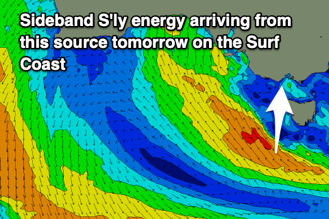
Our tricky pulse of S'ly swell is still on the cards, generated by a fetch of strong to gale-force S/SE winds just south-west of Tasmania today, aimed mostly into the Bight.
We should see some side-band energy coming in at 2-3ft on the Surf Coast, with easing 1-1-2ft sets on the Mornington Peninsula.
Winds will favour the exposed beaches and be out of the E/NE-E early, shifting SE and freshening through the mid-late morning.
Sunday will be poor with a low point in swell and strengthening W/SW tending SW winds as the low moves east and we fall under the influence of it's back end. There might be a period of early light W/NW winds on the Surf Coast but with no size.
Any windswell generated on Sunday will start easing through Monday and with the current outlook, this looks to be worth targeting on the Surf Coast. Winds should be good and fresh out of the W/NW with easing levels of weak S/SW-SW swell from 2-3ft. Nothing great at all but a wave for a grovel.
We then look at easing, fading surf through the rest of the week under W/NW tending gusty SW winds Tuesday, cleaner Wednesday but tiny with a N/NW tending N'ly breeze.
Unfortunately there's nothing significant due into the end of the week, but next weekend onwards is finally looking a bit more optimistic.
A polar frontal system is due to join a mid-latitude front moving in from the west late week bringing some new W/SW energy into next weekend. The American model looks more favourable than the European solution so lets keep a cap on expectations right now, but the developments into the following week look a bit better again.
Let's take another look at next weekend and beyond on Monday. Have a great weekend!


Comments
Prayed to the surf gods last week for some swell for my birthday on the 21st so you can all thank me later...
wacky winds. wacky weather
cross shore, offshore, onshore, no wind, sunny and humid with hail, south swell with west swell and some se swell in the mix, lots of sand on the beach not much in the water, should be good surf but no surf.