Small beachy waves worth capitalising on
Victorian Surf Forecast by Craig Brokensha (issued Wednesday 10th August)
Best Days: Today on the beaches, tomorrow afternoon and Friday exposed beaches
Features of the Forecast (tl;dr)
- Easing W/SW swell tomorrow
- New, inconsistent W'ly swell for the PM, easing Fri
- Strong N/NE tending N winds tomorrow, fresh but easing N/NE tending NE winds Fri
- Small-mod S swell Sat on the Surf Coast with E/NE tending fresh S winds
- Poor building S windswell Sun with strengthening SW winds
- S/SW windswell with S/SW winds early-mid next week
Recap
A tiny start to the day on the Surf Coast with light winds and clean conditions. A small pulse of inconsistent W/SW swell pulsed to a fun 2ft through the afternoon with variable winds, while the Mornington Peninsula was a little lumpy and to 2-3ft in the morning, a better and cleaner 3ft in the afternoon.
Today it looks like the swell is holding an inconsistent 3ft on the Mornington Peninsula and 2ft on the Surf Coast magnets but conditions are a little mixed with some funky S'ly windswell mixed in with the lined up sets.

Fun surf yesterday PM
This week and weekend (Aug 11 - 16)
 The end of the week isn't too exciting surf wise but the exposed beaches should offer a couple of waves into tomorrow afternoon and Friday morning.
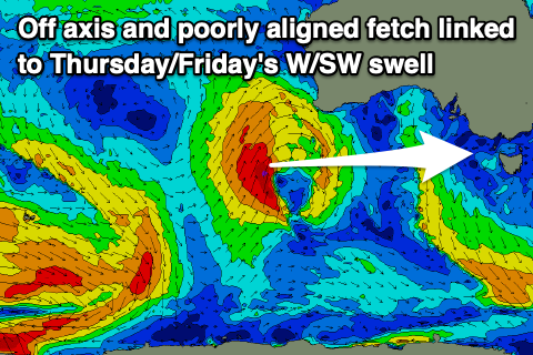
Today's swell will ease through the day, bottoming out tomorrow morning ahead of a tricky pulse of W'ly swell into tomorrow afternoon and Friday morning. This was generated by a poorly aligned fetch of strong to gale-force S/SW winds on the western flank of a mid-latitude low firing up towards Western Australia earlier this week.
The Surf Coast isn't due to see any size with tiny 1-1.5ft sets due across the magnets, a bit better and to 3ft on the sets on the exposed beaches like the Mornington Peninsula.
Winds will strengthen from the N/NE tomorrow, tending more N'ly into the afternoon on the peninsula and Phillip Island, and N/NW on the Surf Coast. This won't be ideal but there'll be fun options for a paddle.
Friday looks better with gusty N/NE winds, easing into the afternoon and tending NE as the swell eases.
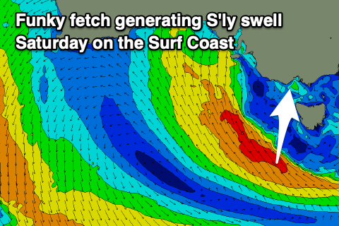
 Moving into the weekend and we've got another funky S'ly swell due across the Surf Coast, generated by a fetch of S/SE winds around the south-western flank of a broad low moving in from the west later week.
This should generate a S'ly swell to 3ft on the Surf Coast but winds will be light out of the E/NE ahead of a S'ly change into the afternoon. Not ideal.
The change will be linked to the low moving east across us, with poor, strengthening SW winds due into Sunday as it deepens off Tasmania's East Coast.
There's the possibility of variable winds early Sunday but the S'ly swell for Saturday will be fading from 1-2ft, with some building S'ly windswell into the afternoon.
Early next week will be dominated by poor, strong S/SW winds as the low sits east of Tasmania, kicking up some poor quality windswell.
Once the low starts to clear and winds swing back to the west later week, there'll be no size to surf, let alone power.
We then look at more mid-latitude lows firing up towards Western Australia bringing small W'ly swells from next weekend with a period of N'ly winds. There are hints of some stronger mid-latitude low activity firing up right over us the end of the following week but any swell will be accompanied by wind. More on this in the coming updates.


Comments
I like how you've given up finishing with 'still nothing showing long term', as it's now a given.
Haha :(
Trying to remember but a typical winter forecast previously would read something like... Perfect 3-4' today, bigger with a Westerly tmrw then large unruly swells, strong onshores to follow, try protected coves. Flat day, then a day for the beaches. Repeat
Right! These forecasts are trickier due to the fluky sources and local winds.
Give me onshore, large building surf, cleaner as it eases and beaches on the back end any day.
“It does matter if it’s 12 second period or a 14 second period. Perioid’s period” - Not Dominic Torreto
It’s been a winter for the beaches that’s for sure. 16 day forey takes us to the 25th and nothing much of interest showing for the surf coast at this stage. That’ll be the end of one of our weirdest / flattest winters of all time surely?
Again you’d be laughing if you lived on the east coast
Me surfing 30 years on Surf Coast. Never seen anything like this.
Extremely hard to stay interested and unfortunately timed with a whole bunch of other shit circumstances for many.
A turd cannot be buffed.
I said to myself earlier "Can't buy a wave at the moment", but that's not true anymore. This forey has me thinking about the tub.
Has anyone kept a journal or record on this? Perhaps a simple review of the daily score ?/10. (Torquay)
Holey damn next week is looking epic!! Wax your boards gents it's Gunna pump!!