A few options on the beaches
Victorian Surf Forecast by Craig Brokensha (issued Monday 8th August)
Best Days: Tomorrow exposed beaches from mid-late morning, exposed beaches Wednesday and early Thursday, exposed beaches Friday
Features of the Forecast (tl;dr)
- Inconsistent, small W/SW groundswell building this afternoon, peaking tomorrow with light NW tending variable then SE winds on the Surf Coast, S/SE to the east
- Inconsistent, small mid-period W/SW swell Wed AM, easing through the day with strengthening NE tending N/NE winds
- Easing W/SW swell Thu with strong N/NE winds
- Inconsistent, small W/SW swell Thu PM and Fri AM with fresh but easing N/NE winds Fri
- Low point in swell Sat with NE winds
- Strong SW winds Sun
Recap
A generally poor weekend of surf with tiny, clean waves across the Surf Coast on Saturday, bumpy to the east, while yesterday a small pulse of weak S'ly swell provided 2ft sets with OK winds for protected spots on the Surf Coast.
The swell faded through the day and this morning we've got clean conditions but tiny surf.
This week and weekend (Aug 9 - 14)
The coming week will remain slow but there should be more options opening up across the exposed beaches over the coming days along with some inconsistent new W/SW swells.
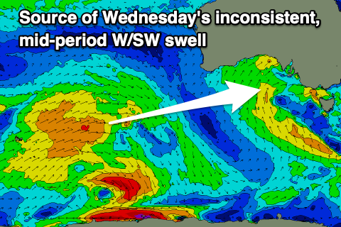
Later today an inconsistent W/SW groundswell is expected, peaking tomorrow ahead of a slightly better mid-period swell on Wednesday morning.
These were generated by the same system, that being an initial fetch of W'ly gales as a polar low formed, followed by strong W/SW winds.
 The groundswell will be very inconsistent and likely only come in at 2ft on the sets across the Surf Coast magnets tomorrow, 3-4ft to the east and with a light NW tending variable SE breeze. The beaches to the east look to clean up through the morning, best from mid-late morning ahead of a weak S/SE sea breeze.
The mid-period swell should offer a touch more size with infrequent 2ft+ sets on Wednesday morning (easing through the day), 4ft to the east and with strengthening NE tending N/NE breeze, favouring the exposed beaches.
This looks to be the pick of the week.
Thursday will become much smaller with easing W/SW energy and stronger N/NE winds will create trickier conditions.
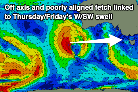
 A new mid-period W/SW swell is due into Thursday afternoon and Friday morning, generated by a strengthening low to the south-west of Western Australia today but the fetch will be poorly aimed in our swell window resulting in no significant size for our coasts.
The Surf Coast may see 1-1.5ft waves with 3ft sets to the east and Friday looks best with a weaker, fresh but easing N/NE breeze.
Saturday unfortunately looks to be a lay day with a low point in swell while Sunday doesn't look much better as a trough moves across us bringing a strengthening SW breeze and no decent swell.
When will this current run of small swells and mid-latitude systems break down?
Unfortunately not into next week, with inconsistent W/SW swells due to persist from the west of Western Australia with varying winds owing to troughy activity in our region. More on this Wednesday.


Comments
Yew!