Fun waves over the coming days
Victorian Surf Forecast by Craig Brokensha (issued Monday 27th June)
Best Days: Tomorrow, Wednesday exposed beaches (afternoon Surf Coast), Thursday morning Surf Coast for the keen, Sunday (check back Wednesday)
Features of the Forecast (tl;dr)
- Easing mix of swells tomorrow with N/NW winds on the Surf Coast (tending N'ly to the east)
- Inconsistent W/SW groundswell building Wed with strong N'ly winds
- Easing W/SW swell Thu with W/NW tending fresh S/SE winds
- Moderate sized pulses of SW-S/SW swell Fri through Sun with fresh S'ly winds Fri, moderate S/SW Sat and variable Sun
Recap
A great weekend of waves across the Surf Coast with all day offshore winds Saturday and our first pulse of mid-period W/SW swell and long-range groundswell coming in between 3-5ft across the magnets. A bit of north in the wind also offered up plenty of options not just on the Surf Coast but also to the east of Melbourne.
Yesterday was similar in size but mostly mid-period energy as winds shifted more W/NW ahead of a shallow W/SW change, favouring protected spots.
This morning we've got a mix of easing, weaker swells from 3-4ft on the Surf Coast along with offshore winds ahead of another shallow SW change.
This week and weekend (Jun 28 – Jul 3)
The shallow nature of today's change will be realised into tomorrow as winds quickly revery back to the N/NW for the morning, shifting more N'ly east of Melbourne and likely holding most of the day.
This will be as our current mix of W/SW-SW swell energy eases further in size, dropping back from 2ft on the Surf Coast and 3-4ft to the east. This should be a fun day of waves with options across all regions.
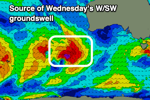
 Wednesday will see winds strengthen from the N'th ahead of a mid-latitude frontal progression pushing in from the west and while starting from a small base, some new W/SW groundswell energy is due to build through the day, peaking into the afternoon.
This swell has been generated by a less than favourably aligned by healthy fetch of strong to gale-force W/NW-NW winds that developed south-west of Western Australia on the weekend, dipping south-east through our swell window.
Size and consistency wise it won't be great for the Surf Coast with building sets to an very infrequent 2ft to possibly 3ft due on the swell magnets into the afternoon, better to the east and reaching 4-5ft.
The swell will ease into Thursday from a small, slow 2ft+ on the Surf Coast with 4ft sets to the east and winds will shift W/NW ahead of a S/SE change during the middle of the day as a trough pushes through.
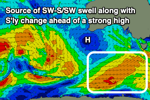
 Now the movement of this trough is still under speculation with it due to feed into a deepening coastal trough off the East Coast, resulting in the formation of a low pressure system. Where and when is still undecided but either way a strong high sitting to our west will support the deepening trough, resulting in a run of poor winds from the S'th from Friday through Saturday, likely weakening on Sunday and becoming more variable.
Swell wise, we've got a mix of SW-S/SW energy due do fill in from Friday, with a mix of periods owing to the varies strength of a progression of polar fronts. The whole progression looks weaker than forecast late last week but we're still expecting moderate sized levels of swell, likely building to 3-4ft on the Surf Coast Friday and 6ft to the east but with fresh S'ly winds, holding a similar size through Saturday and Sunday with reinforcing pulses.
With the local winds, Sunday looks the pick at this stage but we'll have a closer look at this on Wednesday and Friday.


Comments
That was a most excellent weekend. There were really decent chunks at times, and some great shape on the right tide. Anything unusual about the swell: direction/period? More fun than some of the bigger swells that were forecast and sent everyone frothing.
Also, fewer numbers: snow resorts must be packed. Winter wonderland.
100% agree. I got lucky right time right place Saturday; wrong time wrong place Sunday...but still enjoyed that session too.
VJ. Totally concur with you fella. Me and my mate, first in the water at our chosen spot, paddled out and sat in the dark for 20 mins and it was not 3-4ft , definitely some bigger ones rolled through under us as the ocean gracefully lifted us. Spot on about those two peak periods of surge and i agree totally. WHERE was all the doomsday crowd numbers, considering it was the start of school holidays ? The conversation amongst all in the line up was how surprised we were regarding size of swell and lack of size with numbers. Good vibe in the water and a sizeable pod of dolphins cruising through to boot. Only had a two hour break between sessions, clocked up 6 hours of surfing. T’was a fine Saturday of surfing. May it happen again soon.
Nice, 6 hours! We slept in as young one had been up at 4:30 all week going over Melbourne metro area for work, 9-1pmish surf then we went of 4x4ing and managed to get out of a gully that got pretty steep and muddy on its track - fun!
I hear you on the size - in the pulses it was over 4ft, maybe a bit over 5 on a couple by my reckoning. Seemed to be a bit of 'wave lotto' going on out there with which ones would allow easy paddle in, glad I had some foam.
Awesome, sounds on forecast..
"Size wise we should see fairly consistent surf in the 4ft range across the Surf Coast, 6ft+ to the east, while the long-range energy may provide the rare bigger set on the Surf Coast magnets."
ooh yes my first wave was one of those! Felt unreal, it's been a while, lots of space for turns, turns in slow motion.
Went for a similarly big one and got held up in the lip, it got steeper, steeper, my feet placement went wrong as the inside rail slipped - I pin dropped, the board apparently tombstoned then when I did get back out the back my son said "You madman."
Haha, nice!
VJ. My assessment, 4-5ft all day with an odd 6ft set, sneaker wave with approximately 2-3 of them about every 30-40 minutes
I say spot on with the good SwNt forecast Craig.
Yes, VJ mate. Many a time the whole pack just all looked at each other when nobody caught a wave from a 4-5 wave set. There were definitely plenty of waves that were not letting you in or roll into, tide tinkered with it all day, despite there only being a difference of around 1m between high and low. We all know the ocean is the boss who controls us !!!!!!
This as well re: crowd numbers
https://www.willyweather.com.au/news/66076/alpine+businesses+bounce+back...
Yeah that was a cracker of a weekend. Saturday was on all day. Yesterday morning pretty good but there seemed to be a bit of a wobble in it.
Yeah, it was a really good swell. It had a LOT of push and it was also very consistent, at least early Saturday.
Yep agree folks, the Saturday was the one. There seemed to be two surges in my session, the morning around 9ish, and then again coming into 12 - had a check of the swell buoys to roughly confirm this afterward. A handful of waves that went through were absolutely magic, just perfection at size. Got onto a few bombs which felt so good.
After riding 1.5ft through the week as well!
Would say those better pulses would have been the long-range groundswell.
Damn it... was moving all weekend dem the breaks.
Sounds like the universe aligning and you all scored plenty yip yip
Talking about good swells does anyone have any recollection of the 1st of May swell in 2020? I've been running over some old swell charts and graphs for a reference point for when a certain location may break - surprisingly it was more often than I thought :)
That May swell was very sizey across the board and almost straight out of the south but I don't have too much recollection of it, however I don't have my burner phone on me which has a lot of old photos on it
Great to hear of any stories recollections
could check the diary later on & see
No pics of the surf in my camera roll but some screenshots of the snow cams, absolutely puked. Got a pic of sizey but onshore crunchie point from the 2nd May
Here ya go Ruckus..
https://www.swellnet.com/reports/forecaster-notes/victoria/2020/05/01/co...
That's really interesting, that was a very cold, early start to winter in 2020 and we've had similar this year with 'best year since 2000', 'earliest heavy snow since records kept' kind of thing for the ski resorts
Thanks Craig ya legend!
Burner phone empty and with one reason for that… DHDA… crazy times
Have some charting graphs that would blow some peoples minds (actually from Jan 2020 to August 2020 was a very period run)
By experience that extreme southerly angle can have a detrimental effect on some locations and absolutely pump at others (those detrimental locations blocked to a degree by the west coast of tassy and someislands of bass straight)
Always learning
What would you say is the ideal location for the upper echelons of swell generation for vicco waters Craigos? So many variables I guess but somewhere 1/2 to 3/4 ways between the Oz and Antarctic from a sw/ssw angle?