Slow surf tomorrow, better from late week
Victorian Surf Forecast by Craig Brokensha (issued Monday June 20th)
Best Days: This afternoon exposed beaches, tomorrow Surf Coast, Wednesday at times east of Melbourne, Friday through Sunday morning Surf Coast
Features of the Forecast (tl;dr)
- Inconsistent, mid-period W/SW swell building later this afternoon, peaking tomorrow, easing Wed
- Strengthening N/NE winds today, fresh NW tending W/NW tomorrow and N/NW-N Wed
- Low point in swell Thu with strengthening N/NW winds
- Moderate sized + mix of building W/SW swells Fri PM with fresh NW tending W winds
- Early peak in W/SW swells Sat with strengthening NW winds
- Reinforcing W/SW swell Sun with strong NW tending SW winds
Recap
Nothing major to report surf wise on the weekend with tiny levels of weak, W’ly swell with improving winds for the beaches. The Surf Coast was tiny while the Mornington Peninsula was a slow 2ft.
More fascinating was a long-period SE groundswell signal picked up across a few select breaks on the Surf Coast Friday afternoon and to a lesser extent Saturday morning. This filtered through the Bass Strait islands which usually block such swells, with it originating from south-southeast of New Zealand. Sets to 2ft or so were seen and I’ll have an article on this crazy swell source during the week.
This week and weekend (Jun 21 - 26)
Looking at the coming week ahead, we’ve got our inconsistent pulse of mid-period W’ly swell due to arrive through this afternoon, peaking tomorrow and then easing slowly on Wednesday.
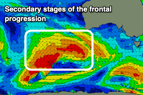
The source of this swell was a distant (west-southwest of WA) and originally less than favourably aligned mid-latitude frontal progression, but on Friday it slipped slightly further south, aiming a better fetch of strong to sub-gale-force W/SW-W winds through our western swell window.
 The swell should arrive later this afternoon and build to 2ft on the sets across the Surf Coast magnets, 3-4ft to the east. Winds will strengthen from the N/NE creating tricky though clean conditions on the exposed beaches.
A peak in swell is due tomorrow with inconsistent 2 to occasionally 3ft sets on the Surf Coast, 4-5ft to the east but with winds shifting NW to W/NW through the morning, holding into the afternoon, spots to the west will be cleanest and best. With the inconsistency of the swell keep your expectations lowered.
The swell will ease through Wednesday and there’s a small window of early N’ly winds for the exposed beaches, shifting N/NW through the day and then likely back to the N later. Size wise the Surf Coast looks to ease from the 2ft range, 3-4ft to the east.
 Thursday will be a lay day as the swell bottoms out under strengthening N/NW winds with Friday seeing NW offshore breezes ahead of a W’ly change and the arrival of a strong, new mix of W/SW swells.
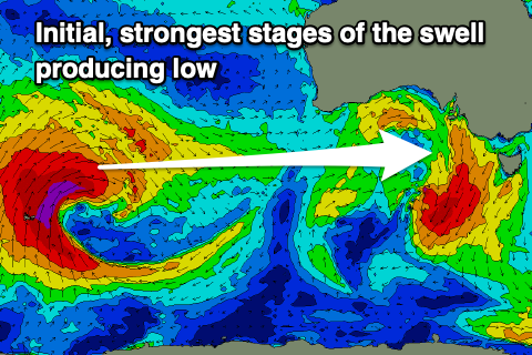
We’re looking at an inconsistent W/SW groundswell mixed in with mid-period energy, all generated by the same system. This is a strong low that’s formed north of the Heard Island region, generating a fetch of gale to severe-gale W’ly winds in our far swell window, with it due to move slowly east over the coming days. This will see a continuous fetch of gale-force W/NW winds projected towards us, with broad, strong W/SW winds then moving under the country later week.
 A wide variety of periods and sizes are expected from Friday afternoon when the swells arrive, building to a peak on Saturday morning to 4ft mostly on the Surf Coast and 6ft+ to the east. There’s a high chance of the odd bigger bomb near 5ft on the Surf Coast at the peak and winds look great, strengthening from the NW as the frontal progression continues east.
We’ve got some reinforcing swell on the cards for Sunday but a low looks to move through bringing a SW change through the afternoon and then swingin winds from SE to E next week as a high moves in. We’ll have a closer look at this Wednesday though.


Comments
Some really fun 1-2ft wedgey runners on the MP Saturday morning with that SE swell in the water
How good!
Hopefully just a little bit more swell while it’s light.
Couple of options..
Nice photos Craig, but by any chance could you edit one of my posts in the Predator thread?
Like a lake on the other side of Melbourne though....2-3ft by tomorrow seems a bit unlikey :(
2ft tomorrow surf Coast??? Hmmmm don't see it.
The buoys are climbing slightly.
Soo west
:(