Cold, windy week
Victorian Surf Forecast by Craig Brokensha (issued Monday 30th May)
Best Days: Wednesday morning protected spots, Thursday Surf Coast, Saturday/Sunday for the keen Surf Coast
Features of the Forecast (tl;dr)
- Small mid-period W/SW swell tomorrow with strong W/NW tending SW winds
- Moderate-large S/SW swell filling in Wed with strong W/NW winds, shifting SW mid-morning
- Easing S/SW swell Thu with W/NW winds
- Small leftovers Fri with strong N winds
- Inconsistent, small mid-period W/SW swell Sat with NW winds
- Similar sized swell Sun AM with strong NW tending W/SW winds
Recap
Small surf to kick off Saturday with slow 2ft sets on the Surf Coast magnets, more size to the east but with poor onshore winds. Some better swell showed into the afternoon creating better waves on the Surf Coast, fun and easing from a clean 2-3ft yesterday. The Mornington Peninsula and Phillip Island were fun yesterday with easing 4-5ft sets and light winds, clean again today with easing 3ft to occasionally 4ft sets.
The Surf Coast was a bit wind affected and easing from a slow 2ft max.


Fun options this AM
This week and weekend (May 31 - Jun 5)
Tomorrow will be a lay day with only a small pulse of mid-period W/SW swell due across the state in the morning and strengthening W/NW tending SW winds as a cold, broad low moves across us (currently bringing heaving snow to the Alpine regions).
 The Surf Coast looks to be only around the 2ft range, building a little into the afternoon but with those onshore winds.
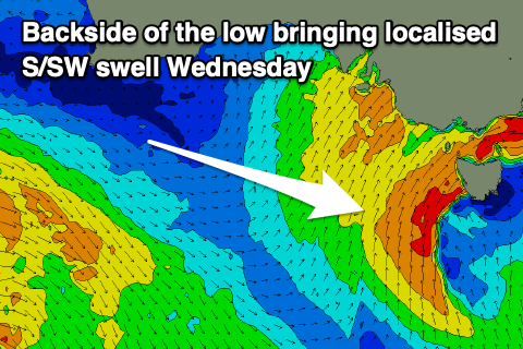
Moving into Wednesday we'll see the backside of the low moving across us, bringing strong SW winds (W/NW early for a period on the Surf Cast) and a moderate to large sized increase in localised S/SW swell.
This swell will be generated by a fetch of strong to gale-force S/SW winds projecting up and into us tomorrow afternoon and evening, with the Surf Coast due to build to 5-6ft with 6-8ft storm surf to the east.
With the period of early W/NW winds there'll be some OK low quality, building waves for the keen and experienced ahead of the shift back to SW.
Thursday is still looking the cleanest with a moderate to fresh W/NW offshore and easing S/SW swell from 3ft to possibly 4ft on the Surf Coast, 4-6ft to the east.
Friday will become smaller as we fall in between mid-latitude storms, with strong N winds and limited options for a quality wave. The Surf Coast looks to be only 1-2ft, with choppy 2-3ft sets to the east.
 A secondary weak mid-latitude low moving in from the west will bring small pulses of mid-period W/SW swell for the weekend, with patchy fetches of below gale-force W/SW winds only likely to produce 2ft to occasionally 3ft sets on the Surf Coast Saturday and Sunday with 3-5ft waves to the east.
Winds will shift back to the NW on Saturday, favouring the Surf Coast, with stronger NW tending W/SW winds on Sunday as the mid-latitude activity pushes across us.
Unfortunately longer term there's still nothing of significance as mid-latitude systems linked to the lingering Nina signal and negative Indian Ocean Dipole make for uninteresting swell generators. More on this in the coming updates.


Comments
There's a bit more size building on the coast today than expected with the low projecting a more favourably aligned fetch of strong SW winds into Bass Strait.
Hey Craigos, It’s defo a J curve sorta arvo. Any expected improvement in periods based on the changes? Cheers in advanced legend
Looks to peak at 12-13s. Mid-period stuff.
Tomorrow morning should also be around the 6ft range across the Surf Coast magnets.
Is this a sign that the swell event will be over earlier than expected, or bigger than expected?
Nah Thursday's size is still on track, just an earlier than expected building trend with the low being a touch further east today. It'll drop quickly but from 3ft+. And be quite weak.
Thanks! It already feels like too long since the last significant swell....keen to get something
Apt title Craigoss.
Chur Bone.
Solid in the bass this arvo. Easy 4-5metres bashing us around
Inzider has the inside word. Cars loaded. Westernport here I come