Fun weekend, localised poor quality swell next week
Victorian Surf Forecast by Craig Brokensha (issued Friday 27th May)
Best Days: Surf Coast tomorrow afternoon, Sunday (beaches into the PM), Monday morning on the exposed beaches, Thursday Surf Coast
Features of the Forecast (tl;dr)
- Small, inconsistent mid-period SW swell later today (with light-mod S/SW winds), with a secondary better pulse for tomorrow PM, easing Sun
- W/NW tending variable winds Sat, N/NW tending variable N/NE winds Sun
- Easing mid-period SW swell Mon AM with strengthening N/NE tending E winds
- Small, mid-period W/SW swell for Tue AM
- Strong SW winds Tue with a moderate + sized increase in local SW swell later in the day (possibly W/NW winds early on the Surf Coast)
- Easing moderate + sized localised swell Wed with strong W/SW tending SW winds (possibly W'lly early)
- Easing mid-period swell Thu with W/NW tending N/NW winds
Recap
Very slow but just surfable waves to the east with infrequent 1-2ft sets and clean conditions, tiny to flat on the Surf Coast.
Today there's been a slight increase in new swell but winds are favouring the Surf Coast which is still tiny. Later this afternoon some new inconsistent SW swell should be seen but with a weak S/SW breeze.

Small runners yesterday PM
This weekend and next week (May 28 - Jun 3)
The weekend and Monday are looking better for a surf across the state as we see some more reliable, though mid-period SW swell energy filling in with favourable winds.
Later today's initial pulse of mid-period SW swell is due to be reinforced by a slightly better increase tomorrow afternoon, easing through Sunday.
These swells were generated by a distant and patchy polar low that formed in the Heard Island region on the weekend and should provide 2-3ft sets across the Surf Coast (most consistent and convincing into the afternoon tomorrow) with 3-5ft to the east. Winds will favour the Surf Coast with a moderate W/NW breeze, tending variable into the afternoon with N/NW tending variable N/NE winds due on Sunday as the swell eases from a similar size.
This will favour the exposed beaches into the afternoon so pencil some time around that.
Monday will also be clean across the beaches but smaller and easing from 3-4ft (2ft Surf Coast) with strengthening N/NE tending E winds.
 The pulse of new, mid-period W/SW swell due into the afternoon from the early stages of the polar front projecting up towards Western and South Australia now looks to arrive later and not hold as much size. In regards to later, after dark on Monday evening.
This is due to the evolution of the front and low being a little slower initially but in regards for swell generation for us it still looks poor.
The majority of the fetch will be projected up into the Bight, angled too far north to be in our swell window and also tracking high across South Australia.
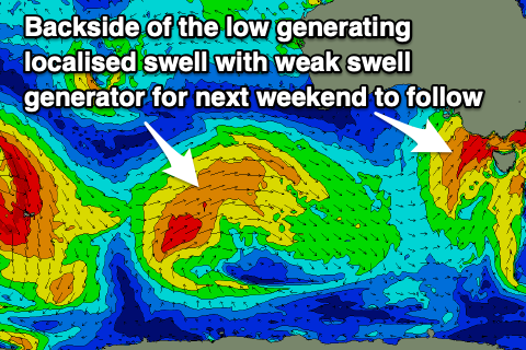
The low is still due to move in across us on Tuesday bringing a strong SW change, though there's likely to be a period of W/NW winds early to mid-morning on the Surf Coast. Swell wise the mid-period W/SW swell looks to be around 2-3ft on the Surf Coast, with a rapid increase in localised SW swell into the late afternoon to a weak 4-5ft or so, 6ft+ to the east.
 Wednesday looks to be a similar size but with no real quality to the swell as a secondary front projects strong to gale-force SW winds into us. Conditions will be generally poor with strong W/SW tending SW winds (likely W'ly for a period west of Melbourne) but not worth chasing.
Thursday looks the cleanest as winds tip back to the W/NW in the morning and NW into the afternoon ahead of another approaching front. This will create improving, cleaner conditions but with weak, easing mid-period swell from 3ft+ on the Surf Coast and 4-5ft+ to the east.
Unfortunately this approaching frontal system has been downgraded in strength with no major swell due into the end of the week/next weekend, with another episode of mid-latitude frontal activity and weaker, localised swell due. More on this Monday, have a great weekend!


Comments
Back to La Niña crap. Hopefully those 2 footers can convince us SCers they’re actually 3 footers..
Nothing wrong with La Nina down east bring it on!