Funky weekend, better options on the beaches next week
Victorian Surf Forecast by Craig Brokensha (issued Friday May 6th)
Best Days: Protected spots tomorrow, Surf Coast Sunday morning, Monday, Tuesday morning exposed beaches, Wednesday morning exposed beaches, Thursday morning, Friday
Features of the Forecast (tl;dr)
- Moderate sized, weak S/SW swell building tomorrow with strong W/NW winds
- Easing S/SW windswell Sun
- Moderate sized, mid-period SW swell for Sun with moderate W/NW-W tending fresh SW winds
- Easing SW swell Mon with variable winds (NW on the Surf Coast in the AM)
- Fading surf Tue with E/NE tending SE winds
- Building mix of inconsistent W/SW and SW swells Wed with N/NE tending SE winds, easing from a similar size Thu with similar winds
Recap
The moderate to large mix of mid-period W/SW energy and very inconsistent groundswell energy for yesterday came in a little smaller than expected across the state. The Surf Coast was a slow 3-4ft with better surf seen earlier in the week, while locations to the east were marginal size wise out of the wind.
Today looks better with the swell coming in at a cleaner and more consistent 3-4ft on the Surf Coast, bumpy and 5-6ft to the east.
This weekend and next week (May 7 - 13)
As touched on earlier in the week, this cold, wet weather is thanks to the remnants of the frontal progression linked to the current swell, pushing up and across the south-east of the country in the form of a broad, multi-centred low.
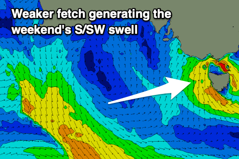
 The low is expected to strengthen through today while stalling across Tasmania, directing a fetch of strong S/SW-S winds through our southern swell window most of today and tomorrow.
The strength of the fetch has been downgraded a touch from Wednesday so the quality of the swell will be low, with periods around the 9-10s range but we should see 4ft+ sets developing on the Surf Coast through the day, 5-6ft to the east.
With the low stalling tomorrow, we’ll see strong W/NW winds blowing all day, favouring protected spots, with Sunday seeing morning W/NW-W winds, shifting gusty SW into the afternoon as the low starts moving east.
The weak S/SW swell will ease into Sunday, dropping from 3ft+ on the Surf Coast and 4-6ft to the east. The surf should be stronger overall though as a new, mid-period SW swell fills in, generated by a broad and healthy fetch of strong to gale-force NW tending W/NW winds swinging in along the polar shelf the last two days.
This swell should maintain 3ft+ waves across the Surf Coast all day, 4-5ft+ to the east before easing from 3ft and 4-5ft respectively Monday morning.
As the low clears Monday winds should become lighter and more variable, NW on the Surf Coast and possibly N’ly to the east, with variable sea breezes due into the afternoon with an easterly bias. This should provide fun options east of Melbourne though likely not quite perfect.
The surf will fade through Tuesday and a morning E/NE breeze will favour the exposed beaches to the east with easing 2ft waves on the Surf Coast, 3ft+ on the peninsula.
 Also mentioned in Wednesday’s notes was the blocking effects of a slow moving high pushing in behind the slow moving low currently sitting across Tasmania. This will put a block across our main swell windows this weekend while also being squeezed by inland instability, resulting in a period of NE winds Wednesday to Friday (more N/NE on the latter).
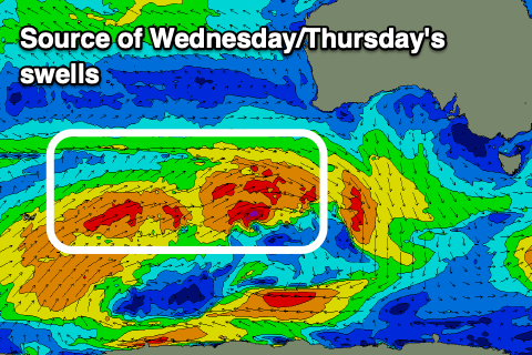
This will favour locations to the east, and we should see an inconsistent mix of W/SW mid-period and SW groundswell energy filling in Wednesday afternoon and Thursday as a frontal progression tries to push the high off to the east. The mid-period energy will be generated by a distant frontal progression, south-west of Western Australia, with this dipping on approach to us while strengthening. This will generate the additional SW groundswell energy with both arriving Wednesday, building to a peak later in the day, easing Thursday.
There’s still some fluidity to the sizes but we should see the Surf Coast reaching 3ft+ into Wednesday afternoon, 5-6ft to the east, easing from a similar size Thursday morning. More on this Monday. Have a great weekend!


Comments
I like how you have the forecast for sat as sw winds, haha!! Keep all those that don't know out of the waves! Nice!
Premium Subscribers get the truth :-)
I'm not premium subscriber :-). Just not a doosch! Haha
Telling people that the forecast is wrong the day before is an A-grade doosch thing to do, though.
Hey Craig the forecast graph for tomorrow is showing swell as 8ft in arvo with and WSW winds. Is that not the case? For MP/Island