Improving weekend of surf with tons of swell
Victorian Surf Forecast by Craig Brokensha (issued Friday 25th March)
Best Days: Selected spots east of Melbourne tomorrow morning, Sunday, Monday morning
Features of the Forecast (tl;dr)
- Moderate sized mid-period SW swell arriving this afternoon with light-mod S winds
- Moderate sized S/SW swell tomorrow, with a reinforcing pulse to a similar size arriving late AM Sun
- Light-mod E/SE tending fresh SE winds tomorrow (tending light E/NE for a period mid-late AM east of Melbourne)
- Light, local offshore winds Sun AM, tending variable to the east into the PM and light E/NE-E on the Surf Coast
- Easing surf Mon with N/NW winds ahead of a late morning S/SW change, freshening
- Weak S/SW swell Tue AM with S/SE winds
- Mod-large SW groundswell for Thu with strong S/SE winds, easing Fri with E/SE tending S/SE winds
Recap
Good surf across the Surf Coast and Phillip Island the last two mornings with an initial pulse of mid-period SW swell yesterday coming in at 3ft to occasionally 4ft to the west and 4-5ft+ to the east. Today the swell has steadied, continuing to offer straighter 3-4ft sets on the Surf Coast with 4-5ft sets continuing to the east.
Conditions should be fun most of the day with weak S'ly sea breezes.

Good size holding this morning
This weekend and next week (Mar 26 – Apr 1)
With the current mid-period energy in the water and a further pulse of SW swell due this afternoon (maintaining 3-4ft sets on the Surf Coast and 5ft surf to the east), we've got our slightly stronger (in period) S/SW swell tomorrow, with a good reinforcing pulse for Sunday.
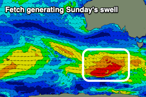
All this swell activity has been generated by a great progression of relatively weak but persistent polar fronts, generating fetches of strong to sometimes gale-force winds through our south-western and southern swell windows.
 The final front in this progression is currently generating a broad fetch of W/NW gales south-west of Tasmania and will pass under their state today.
So tomorrow we'll see a fresh pulse of S/SW swell across all locations generated by polar W/SW winds mid-this week with 3-4ft waves on the Surf Coast and 4-6ft sets to the east. Seeing the size the last two days we can likely expect the odd bigger one on the Surf Coast magnets tomorrow and Sunday.
Sunday's reinforcing SW swell, generated by the W/NW fetch looks to arrive late morning, with a temporary dip in size early in the day, rebounding back to 3-4ft+ on the Surf Coast and 4-6ft on the Mornington Peninsula.
Looking at the local winds and tomorrow is dicey with a light to moderate E/SE breeze due across all locations in the morning, fresher SE into the afternoon. There's a good chance winds will tend light E/NE mid-morning east of Melbourne but options will be limited with the swell size.
Sunday looks the pick with light, local offshore winds (N/NW Surf Coast and N/NE east of Melbourne), tending variable to the east into the afternoon and light E/NE-E on the Surf Coast.
Monday morning will offer a fun window of clean conditions on the Surf Coast with a N/NW offshore ahead of a trough and shallow S/SW change late morning, freshening into the afternoon.
The swell will be on the ease but still in the 3ft range, 4ft+ to the east.
 The trough itself will be fast moving but generate a short-lived fetch of S/SW winds through our swell window Monday, generating a small pulse of S/SW swell for Tuesday morning, easing from 2-3ft on the Surf Coast and 4ft to the east. Winds will linger from the S/SE on Tuesday though, creating bumpy conditions with fresher SW winds expected on Wednesday as a cold front clips the state.
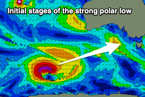
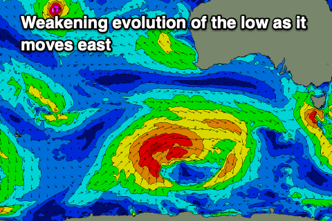
Now, this SW change will spawn off a broad, weakening polar low that's due to develop south-east of the Heard Island region on the weekend.
The low will be initially strong with a fetch of severe-gales generated through our long-range swell window, with it weakening while pushing east and under the country early next week.
 A moderate-large SW groundswell is due from this low, arriving overnight Wednesday and peaking Thursday to 4-6ft on the Surf Coast and 6-8ft to the east but with strong S/SE winds as a strong high moves in behind the front on Wednesday.
Winds are to to slowly improve on the backside of the swell event Friday but more so next week, swinging slowly SE then E/NE which will favour the beaches. More on this Monday. Have a great weekend!


Comments
Thanks for the swell Craig!
Hope you west coasters are getting some action, the MP has only been for the humans who have no commitments and can persuade the tidal rips, or the Chuck Norris's who can battle the special ops for a two-wave hold down.
Shit rock
Yeah or shit rock,
Spotted a few leg burners from Die Hairs corner all the way through to the Smiley Shore Banger, only for the non-after-work salt-off. Too much of a show bag after 4.
Was pretty surreal paddling out in that fog in the dark this morning ...