Persistent north-east winds and a solid swell
Victorian Surf Forecast by Craig Brokensha (issued Monday 14th March)
Best Days: Beaches tomorrow, and Wednesday, selected spots Saturday morning, Sunday morning, Monday through Wednesday on the beaches next week
Features of the Forecast (tl;dr)
- Mid-period reinforcing SW swell tomorrow with light NE winds ahead of S/SE sea breezes, easing Wed with mod-fresh NE winds
- Stronger N/NE winds Thu with a low point in swell
- Tiny Fri with gusty S/SW winds
- Moderate-large W/SW groundswell for Saturday with light E-E/NE tending SE winds
- Smaller Sun with a reinforcing W/SW groundswell under NE tending SE winds
- Smaller Mon through Wed with NE winds
Recap
A drop in swell and light winds across most regions and 2-3ft sets on the Surf Coast, a fun 3-4ft to the east.
Our strong pulse of new SW groundswell for yesterday morning came in nicely with solid, clean 4ft sets across the Surf Coast magnets and 6ft to the east, but a tad inconsistent which wasn't ideal with the holiday crowds.
This morning the swell is back to a smaller 2ft with light winds, best on the beaches to the east but also fun on the Surf Coast magnets.
This week and weekend (Mar 15 – 20)
The fun run of surf for the beaches across both regions will continue over the coming days, but for the most size hit up tomorrow.
We should see a fun, new mid-period SW swell filling in tomorrow across the state, generated by a weak fetch of W/SW winds trailing the strong polar low linked to yesterday morning's SW groundswell.
Sets to 2-3ft are due on the Surf Coast, 4ft+ to the east and with light, morning NE winds ahead of S/SE sea breezes.
The swell will start easing into Wednesday from 2ft max on the sets across the Surf Coast and the 3ft range to the east with a moderate to fresh NE breeze that looks to hold most of the day.
Come Thursday no size is expected to be left and winds will strengthen from the N/NE ahead of an evening SW change which will freshen from the S/SW into Friday. Therefore make the most of tomorrow and Wednesday morning.
Now, as stated last week, we've got some healthier frontal activity due through the middle to end of the week and winds will improve quickly as a high quickly moves in behind Friday's onshore winds, swinging winds to the E-E/NE on Saturday morning and then NE Sunday morning.
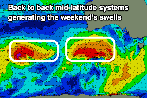
 Swell wise, a moderate to large sized W/SW groundswell is due to fill in late Friday evening, peaking early Saturday morning, generated by a strengthening mid-latitude frontal system projecting towards Western Australia tomorrow and Wednesday. A great fetch of W/SW gales will be generated, possibly reaching severe-gale as the front dips south-east on approach to us while forming into a polar low.
The swell looks solid and consistent with sets to 3-5ft due on the Surf Coast swell magnets, 6-8ft to the east and with that morning easterly breeze.
Sunday morning looks a bit smaller but a reinforcing W/SW groundswell is due into the afternoon, generated by a trailing frontal system producing a fetch of W/NW gales. This should maintain 3ft to occasionally 4ft sets on the Surf Coast all day with 6ft surf to the east with the morning NE breeze. The swell will then start to east Monday and winds are tricky as a trough pushes through, bringing morning NE winds, possibly giving into SE sea breezes, followed by fresher N/NE winds on Tuesday ahead of a change Wednesday morning.
Some small, reinforcing mid-period swell is possible Tuesday but we'll look this closer on Wednesday.


Comments
Didn't take long for the Woolies locals to rub vas on the lenses.
Think it’s just condensation as it seems to clear up as the day progresses. And I don’t think they’re easily accessible. They look to be mounted on a mast on top of club roof.
Lol - like it would make a difference!
Might be virga.
Thanks for the addition to my vocabulary Craig.
Great word eh!