Another week of tiny surf, improving into next week
Victorian Surf Forecast by Craig Brokensha (issued Monday 24th January)
Best Days: Wednesday morning desperate surfers exposed beaches, Monday morning and Tuesday morning on the beaches next week
Features of the Forecast (tl;dr)
- Small-tiny, inconsistent W/SW swell building Tue PM, easing Wed with light E/NE tending S/SE winds tomorrow and mod-fresh E-E/NE tending SE winds Wed
- Easing tiny swells Thu with strong but easing N/NE winds
- Tiny Fri with N tending S/SW winds
- Inconsistent W/SW groundswell for Sun, peaking through the day with fresh E/SE tending strong SE winds
- Easing W/SW groundswell Mon with N/NE tending S/SE winds, smaller Tue with similar winds
Recap
Nice conditions on the beaches with an inconsistent, background W/SW swell providing 2ft to occasionally 3ft sets on the Mornington Peninsula through Saturday, tiny on the Surf Coast. Yesterday morning was similar and OK for the keen on the exposed beaches with the swell easing back a touch in size today.
This week and weekend (Jan 25 – 30)
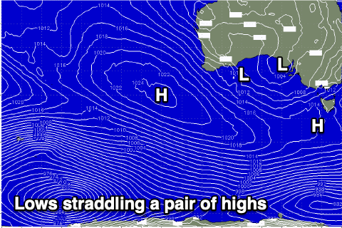
Humid weather is feeding in from the west as a broad, slow moving mid-latitude low drifts very slowly eastward. The low will continue to slowly edge towards us over the coming days, bringing increasing rain/storms into Wednesday evening.
 As it does so it'll be squeezing a broad area of high pressure sitting south-east and west of us, putting a block across our main swell windows.
This will keep the exposed beaches small to tiny through the coming week, with only a very inconsistent W/SW swell possibly providing infrequent 2ft sets on the Mornington Peninsula later tomorrow and Wednesday morning.
Winds look light out of the E/NE tomorrow morning ahead of S/SE sea breezes, a little fresher E-E/NE on Wednesday morning ahead of sea breezes and with some building SE windswell.
As the low starts to move across us into the evening winds may tend variable with Thursday seeing strong N/NE offshore winds, easing into the afternoon and evening ahead of a shallow S/SW change pushing through Friday. The timing of this looks to be more so into the middle of the day but alas no major swell will be in the mix at all.
Moving into the weekend, Saturday will be another lay day as a new ridge of high pressure slides in behind the low and trough on Friday, bringing strengthening S/SW winds that will then shift E/SE into Sunday morning as the high continues east (strong SE into the afternoon).
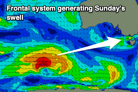
 Swell wise, we should see a fun new W/SW groundswell arriving overnight Saturday and filling in Sunday, generated by a strong polar frontal system firing up around the Heard Island region tomorrow afternoon. A great though distant fetch of gale to severe-gale W/SW winds will be projected through our swell window, with the storm weakening south of Western Australia Thursday evening.
The swell will be inconsistent but should come in at 3-4ft on the Surf Coast and 5-6ft to the east though with those poor winds.
Winds and conditions will improve through early next week as the swell eases, opening up the beaches to good surf Monday morning and Tuesday morning.
Longer term a similar but weaker polar front looks to generate a weaker W/SW swell for Tuesday afternoon/Wednesday next week, though another trough will bring a SW change as it arrives, creating poor conditions. We'll have a closer look at this Wednesday.


Comments
https://regionalroads.vic.gov.au/map/barwon/new-retaining-wall-on-the-gr...
I spotted that today, but only just read it properly. Just noticed it's on the beach side. I hope these guys know what they're doing.