Poor run of winds, spoiling a good swell
Victorian Surf Forecast by Craig Brokensha (issued Friday 14th January)
Best Days: The Mornington Peninsula and Phillip Island this afternoon/evening, Friday morning next week on the beaches
Features of the Forecast (tl;dr)
- Small, weak mid-period SW swell building this afternoon as winds hold from the NE
- Fading, tiny mid-period SW swell tomorrow with W/NW tending SW winds (W/SW-SW east of Melbourne)
- Tiny swell Sun with variable tending S/SE winds
- S/SW winds Mon with a possible late increase in new swell
- Mod-large W/SW groundswell Tue with strong S winds, easing Wed with strong SE winds
- Mod sized SE windswell Wed PM and Thu with strong E/SE tending SE winds, easing Fri with morning E/NE winds
Recap
Cleaner conditions across the beaches yesterday morning but with a drop in swell and weak waves for the keen. The Surf Coast was 2-3ft with 2ft to occasionally 3ft waves on the Mornington Peninsula.
Today the swell is even weaker and conditions favourable though lumpy with a variable offshore wind. A small, weak increase in mid-period SW swell is due this afternoon across the state, reaching 1-2ft tops on the Surf Coast and 2ft to possibly 3ft to the east as winds hold from the NE, so a late afternoon session is worth a look.
This weekend and next week (Jan 15 – 21)
Any small increase in new swell seen this afternoon with that NE wind will fade into tomorrow with tiny 1-1.5ft waves due on the Surf Coast, small to the east.
Winds will shift westerly as a surface trough pushes in from the west this evening, with lingering W/SW-SW winds due on the Mornington Peninsula, clean on the Surf Coast with a W/NW offshore but this is a moot point. Variable winds are due on Sunday morning ahead of S/SE-SE sea breezes but with no new swell.
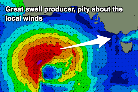
 Moving into next week we've got our moderate to large sized W/SW groundswell due, generated by a strong low developing south-west of Western Australia this evening.
The low will strengthen over the weekend, generating a great fetch of gale to severe-gale W/SW winds through our western swell window, slowing on approach through Sunday before weakening and moving slowly across Tasmania on Monday.
We may see some new swell building on dark Monday but the bulk of the energy is due on Tuesday with 4-5ft+ sets on the Surf Coast magnets, 8ft to the east as it peaks.
Unfortunately as touched on in the previous notes this week, a high pressure ridge will move in behind the low, bringing S/SW winds on Monday that will then be stronger from the S'th on Tuesday, leaving nowhere to really hide.
Winds will then shift SE on Wednesday and strengthen as the swell eases and some new SE windswell takes its place. This will be thanks to a deepening trough on the southern NSW coast, squeezing the high as it pushes east, with moderate levels of SE windswell due to persist into Thursday with strong E/SE-SE winds.
Friday looks to offer cleaner conditions as winds tip back to the E/NE but again there'll be no groundswell left in the mix with easing levels of weak, SE windswell.
More on this Monday though, have a great weekend!


Comments
Cmon Huey get your shit together, ffs.
We need offshores and swell at the same time..
Hey Craig, if we increase our subscription can you get us a better forecast?
That's the end game.. ;) muwhahaha.
We get one good swell and it’s onshore Hahahah fark me
Would even a tiny uptick in size this arvo be too much to ask. Fucken oath it would be.
Relentless!!!!!
Kinda funny the south coast of NSW is gonna cop that swell as it passed us aswell
Cheers craigos, great forey as per. Shame about the conditions. When do you recon this La Niña will end?
Cheers craigos, great forey as per. Shame about the conditions. When do you recon this La Niña will end?
Summer usually ends in march
OK Dr Surf is Entering the Swellnet Discourse. To start things off I’m Coining a New Phrase. TOMO. You got it. “Trauma Of Missing Out” Surfing will adopt Crypto coz they know what TOMO is all about. The Horror of Waves Pumping and you’re Not There.