Fun beachy options from Thursday
Victorian Surf Forecast by Craig Brokensha (issued Monday 3rd January)
Best Days: Keen surfers mid-late morning east of Melbourne tomorrow, Thursday morning, Friday morning exposed breaks, possibly Sunday/Monday mornings
Features of the Forecast (tl;dr)
- Small, weak W/SW tomorrow with pre-dawn fresh S/SE winds, easing and tending E/SE before strengthening from the S/SE again late morning
- Mix of building SW and SE swells Wed with strong SE winds, E/SE at periods to the east
- Easing mix of SW and SE swells Thu with easing E/NE winds, shifting E-E/SE into the PM
- Small, fading SW swell Fri with local N'ly offshore winds ahead of sea breezes
- Fresh SW change Sat with a low point in swell
- Building, inconsistent mid-period SW swell Sun, easing Mon with S/SW winds (possibly variable each morning)
Recap
A small reinforcing pulse of swell maintained fun 2ft waves on the Surf Coast Saturday with 3ft sets to the east under offshore winds, but the window was small with an onshore change moving in mid-morning to the west, more so just before midday to the east.
Yesterday was poor with onshore winds and a low point in swell. Today conditions are still poor but with a slight lift in average W'ly swell.
This week and weekend (Jan 4 - 9)
The next few days are looking average but we should see improving surf into Thursday.
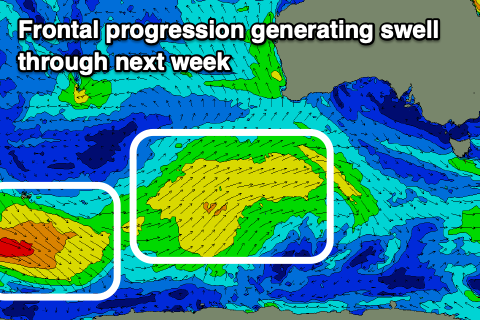
Swell wise a weak, mid-period W/SW swell from a front passing under Western Australia through Friday and Saturday morning should provide 2ft sets on the Surf Coast magnets with 3-4ft sets to the east today and tomorrow.
We'll likely see a window of workable conditions as a fresh, pre-dawn S/SE breeze eases and shifts E/SE before strengthening from the S/SE again late morning. It's not worth driving for but if in the region check mid-late morning for a wave.
 As we move into Wednesday winds will strengthen from the SE (tending E/SE through the morning across locations east of Melbourne) kicking up a poor SE windswell as some slightly better, mid-period SW swell fills in.
The source of the mid-period energy was a slightly stronger, small low forming on the back of the frontal progression pushing under WA though further south in latitude.
Wind strengths weren't overly impressive and it's likely the local SE windswell will be much more noticeable across the Surf Coast but we should see sets to 3ft on the Surf Coast magnets from the mid-period swell later Wednesday, easing from a similar size Thursday, 3-5ft to the east.
Thursday is the pick as winds ease through the morning and tend E/NE, with a peaky mix of swells on the Mornington Peninsula, a bit all over the place on the Surf Coast but best on the beaches.
Winds will improve further Friday and tend more N'ly, locally offshore across both regions but the swell will be small and fading from 1-2ft and 3ft respectively on the Surf Coast and Mornington Peninsula.
 Make the most of this window of cleaner conditions as a trough will bring a fresh cycle of onshore SW, tending S winds from Saturday.
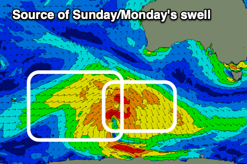
Swell wise, a new, inconsistent mid-period SW swell is due to fill in Sunday, generated by a broad but generally weak polar low firing up south-west of Western Australia on Wednesday. We'll see a pre-frontal fetch of strong to near gale-force W/NW winds giving way to similar strengthen post-frontal W/SW winds, with an increase Sunday, easing slowly Monday.
The Surf Coast should see 3ft sets developing into Sunday afternoon with 4-5ft+ waves to the east, easing from a similar size Monday but with those onshore winds mentioned above. There's a chance for more variable breezes developing both Sunday and Monday mornings but we'll have to keep an eye on this with the local instability.


Comments
Forey online before 8am on a public holiday. Really appreciate you blokes consistently putting in the yards year in, year out.
Thanks Tim, just getting them out of the way early so I could target a local rip bowl on the right tide.
x2 Craigos. Heading back to Vic tonight and good to see there’s a bit to work with after copping a fair run of SE’ly winds on south coast SA. got a tiny wave on the mid on the way back to town over lunch which was a bonus.
Lol what ok. Keep talking up Friday, hope you guys like 2-3 foot broken up wind swell mixed with 1 foot ground swell. And epic job talking down them two sneaky swells that hit over new years. Was small but extremely fun
Well you were spot on mr poo, absolute rubbish
Yesterday looked fun.